
Skip to content
DAMWeather DAMWeather DAMWeather

The weather can get scary. Reporting on it doesn't have to be.

DAMWeather DAMWeather DAMWeather

The weather can get scary. Reporting on it doesn't have to be.

  • About Me
  • All Bylines
    • Books, Bylines, and Press
    • The Skies Above (Book)
    • Extreme Weather (Book)
    • The Weather Network
    • The Vane
    • Forbes
    • Capital Weather Gang
    • Mental Floss
  • Maps
    • Hurricane Maps
    • Hurricane Names
    • Monthly Tornadoes
    • Tornado Tracks
    • F5/EF-5 Tornadoes
    • SPC High Risk Days
  • GIS Resources
  • Contact Me
    • Bluesky
    • Facebook
    • Instagram
  • wxdam.com
  • About Me
  • All Bylines
    • Books, Bylines, and Press
    • The Skies Above (Book)
    • Extreme Weather (Book)
    • The Weather Network
    • The Vane
    • Forbes
    • Capital Weather Gang
    • Mental Floss
  • Maps
    • Hurricane Maps
    • Hurricane Names
    • Monthly Tornadoes
    • Tornado Tracks
    • F5/EF-5 Tornadoes
    • SPC High Risk Days
  • GIS Resources
  • Contact Me
    • Bluesky
    • Facebook
    • Instagram
  • wxdam.com
Close

Search

A Wildfire Likely Spawned a Severe Thunderstorm in Texas

By Dennis Mersereau
May 12, 2018 3 Min Read

The ground can influence the weather in ways we don’t always realize are happening. Cities warm up the atmosphere around them. Air lifting over the sides of mountains can create rain and snow. Wildfires can cause billowing cumulonimbus clouds. And some of those fires can even trigger thunderstorms like the supercell that popped up over the Texas Panhandle on Friday afternoon.

Satellite and radar imagery showed smoke rising from a large wildfire southeast of Amarillo, Texas, on Friday afternoon. The fire grew in size through the afternoon and the heat generated by the fire spawned a rather hefty pyrocumulonimbus cloud.

There was enough instability over Texas and Oklahoma on Friday to support the development of thunderstorms, but only if the cap broke. A “cap” is a nickname for an inversion layer, or a layer of warmer air sitting atop a layer of colder air. An inversion layer can prevent air from freely rising through the atmosphere, stifling the development of showers and thunderstorms. Stronger caps are harder to erode.

Something needs to break the cap in order for a storm to form. Strong surface heating during the day can raise low-level temperatures enough that rising air can reach a speed at which it breaks through the cap like cheap aluminum foil. Sometimes it takes forcing from a feature like a cold front or a sea breeze to give rising air the extra oomph it needs to break through the inversion.

Today, the force that helped break the cap was the heat from the fire.
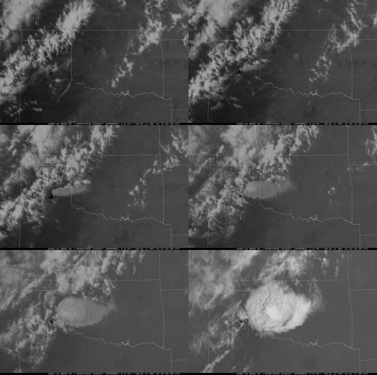
You can follow the progress of the wildfire using GOES-East’s shortwave infrared product. The heat generated by the fire makes the affected area southeast of Amarillo show up as a black splotch on satellite imagery. Smoke billowing northeast of the fire starts off a darker shade of gray at first, but the smoke eventually becomes obscured by the pyrocumulonimbus clouds as the afternoon wears on.

The thunderstorm developed in the late afternoon. The storm was able to tap into the instability already present and organize into a supercell, complete with at least one report of quarter-size hail and a beautiful overshooting top and expansive anvil that shows up well on visible satellite imagery.

You can even track the smoke and thunderstorm on radar imagery out of Amarillo. The smoke appears on radar as the steady stream of returns flowing northeast on the eastern side of the radar. The thunderstorm develops around 5:00 PM CDT and continues to grow as it approaches the Oklahoma border as it feeds off of instability in the atmosphere.

While fire-induced thunderstorms are rare, it’s not out of the question when there’s a large fire in the right environment. The devastating fires in and around Fort McMurray, Alberta, back in May 2016 were strong enough to spawn pyrocumulonimbus clouds that caused lightning, which, in turn, started even more fires.


[Vis/IR Combo: Dennis Mersereau (data via AllisonHouse) | Radar/Sat.: College of DuPage | Model Image: PivotalWeather]

Please consider subscribing to my writing on Patreon. Reader-funded journalism is more important than ever and your support helps fund engaging, hype-free weather coverage.
Author

Dennis Mersereau

I have 15+ of experience providing hype-free weather information for folks across the United States and around the world. In addition to DAMWeather, I also contribute to The Weather Network as a digital writer and weather specialist.

Follow Me
Other Articles
Previous

A Wildfire Likely Spawned a Severe Thunderstorm in Texas

Next

Severe Thunderstorms Likely in the D.C. Area This Evening


Local ◈ UTC
Facebook | Bluesky
Instagram | Threads | Email
DAMWeather is now ad-free! Everyone benefits from engaging, hype-free weather coverage. Please consider supporting my efforts through Patreon:


Order The Skies Above today!

Bookshop.org || Barnes & Noble
Mountaineers Books || Amazon

My latest book, The Skies Above, is now available!

Did you know a puffy cloud can weigh millions of pounds? Or that every rainbow you see is unique to you?

Our atmosphere is full of spectacular sights that are always within your reach. Glistening layers of fog, gorgeous sunsets, and brilliant meteors flashing through the sky can light up even the calmest day.

The Skies Above, published by Mountaineers Books, is a celebration of what we overlook when we look up. I was thrilled to work with the editors and illustrators at Indelible Editions to share with you the quotidian beauty of our sky.

Order your copy now and learn about the wonders we take for granted every day.

I teamed up with the editors of Outdoor Life magazine to write The Extreme Weather Survival Manual, your guide to surviving and thriving in almost any weather condition. Whether you're an avid outdoorsperson or you enjoy watching the radar from the comfort of your home, you're sure to find helpful tips, advice, and new bits of knowledge in this fascinating book.

You can buy my book today through Amazon.
  • 2026 (34)
  • 2025 (49)
  • 2024 (59)
  • 2023 (43)
  • 2022 (57)
  • 2021 (71)
  • 2020 (83)
  • 2019 (88)
  • 2018 (92)
  • 2017 (1)
  • 2016 (4)
  • 2015 (10)

Copyright 2026 — DAMWeather. All rights reserved. Blogsy WordPress Theme