How the June 2018 Heat Wave Triggered Three Derechos in One Day

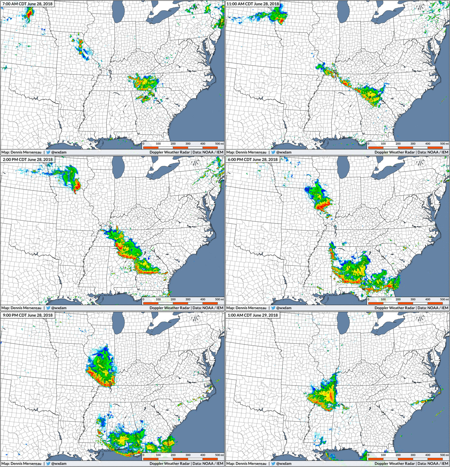
The word “derecho” is usually not allowed on this wholesome website. I try not to use the word unless we’re talking about an event that’s already happened or the SPC outright uses it in one of their forecasts. That being said, yesterday we saw three derechos in one evening as a result of the growing heat wave. The storms resulted in more than 500 reports of wind damage across a dozen states, claiming one life in Alabama and knocking out power to hundreds of thousands of people. All three storm complexes were strong “mesoscale convective systems,” a common type of thunderstorm event during the summer and one you can almost expect to see during a heat wave.
A derecho is a strong, long-lived squall line that produces lots of wind damage along a path stretching hundreds of miles long. The derechos that formed on Thursday were fraternal twins. They were separated by more than a thousand miles, but they all came into existence because of the same ridge producing the heat wave.

The first destructive line of storms moved southwest through Georgia and Alabama on Thursday afternoon. (Another distinct line formed to its southeast in Georgia, but it only produced scattered wind damage reports.) The second derecho began life as a single supercell over Nebraska on Thursday morning that eventually grew into a squall line that raced south into Mississippi before fizzling out after midnight on Friday. A third derecho over the northern Plains produced a wind gust as high as 96 MPH in North Dakota and flipped a small airplane at an airport in Minnesota.
A mesoscale convective system, or MCS for short, is an organized line of thunderstorms that can produce damaging winds across hundreds of miles. The strongest MCSs can last for 12 hours or longer, traversing half the length of the United States before finally petering out.
Most MCSs are easy to spot on radar imagery because they’re thick squall lines with a well-defined shield of rain trailing them. The storm comes on suddenly. The hurricane-like winds and rain can last up to 15 minutes before finally subsiding and giving way to a couple of hours of light to moderate rain. The winds can be so violent that people who go through an intense MCS swear they were hit by a hurricane or tornado instead.
What makes an MCS different from other types of thunderstorms?
Thunderstorms “breathe” in the sense that they inhale warm, unstable air in an updraft and exhale cool, stable air with the rain in a downdraft. The vast majority of thunderstorms end up choking on their own downdrafts as the rush of cool air, known as a cold pool, cuts off the updraft and robs the storm of the instability it needs to survive.
When upper-level winds are favorable, though, thunderstorms can merge and share one large cold pool. The storms attach themselves to the leading edge of the cold pool as it races downwind, allowing the storms to thrive as they move into more unstable air. The line of storms doesn’t die until they either run out of unstable air or the cold pool “escapes” ahead of the storms, robbing them of the lift they need and causing them to choke on cool, stable air.
The intense winds that can accompany an MCS comes from the “rear inflow jet.” Friction and pressure differences within an MCS cause the air to begin circulating within the complex of storms. This circulation leads to the development of a sharp jet of winds that moves from the back of the storms to the front. This rear inflow jet gets shoved to the ground by the downdraft at the leading edge of the thunderstorms, causing the sudden, intense burst of winds that gives a severe MCS its bite.
You can see a mesoscale convective system any time of the year, but they’re pretty common around June and July as the intense summer heat starts building over the United States.
I mentioned the possibility when I had a conversation with the little voice in my head on Tuesday:
Q: What kind of severe weather is favored during heat waves?
A: Mesoscale convective systems are a nasty habit of heat waves,
especially along the outer edge of the ridge where the dynamics for such
thunderstorm events are best. An MCS is commonly known as a squall line
or sometimes even a d******.Q: What’s a d******?
A: I’m sorry. That word is censored on this good, moral blog.
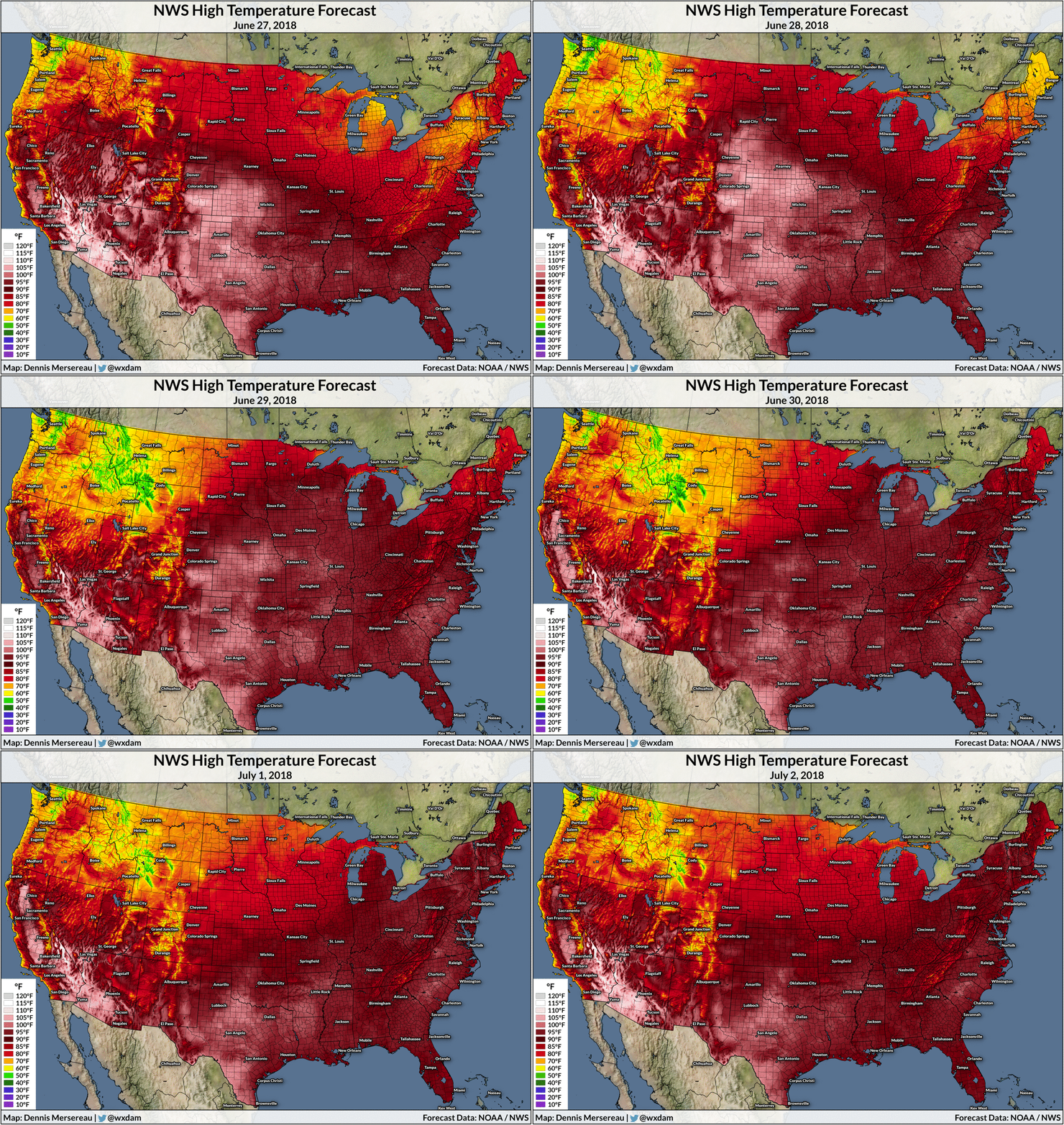
Even without ever looking at the Storm Prediction Center’s forecast, it’s a decent bet to say that severe squall lines are possible when there’s a heat wave like this. All of the storm complexes we saw on Thursday formed along the outer periphery of the ridge of high pressure that’s allowing it to get so darn hot this week.
Heat waves are a breeding ground for this type of severe weather because of the dynamics involved in their creation. There’s usually a sharp temperature and moisture gradient along the edge of a heat-producing ridge. This gradient, a stationary front, serves as the focus along which thunderstorms can develop and organize. Strong instability allows thunderstorms to grow and thrive, and upper-level winds along and north of the ridge of high pressure allows the storms to merge and organize into a single line.

If you overlay Thursday afternoon’s radar over surface temperatures at the same time, you can actually see how the thunderstorms are riding the ridge around the heat.
It’s not too common to see three separate lines of storms on the same day meet the definition of a derecho, the “d-word” that meteorologists hesitate to use in public for fear of whipping their audience into a panic.
A derecho produces lots of wind damage over a path that’s at least 250 miles long. 200 miles? Not a derecho. 250? Ring the alarm. The, uh, specificity of that definition is about as arbitrary as anything else in meteorology; a squall line that only lasts for 50 miles could level a town’s power grid and rip the roof off the high school, but it wouldn’t technically be a derecho. The term came into the national hype vocabulary after an intense derecho trashed the Washington D.C. and Baltimore metro areas on this date in 2012.
Derechos are serious business. A study conducted in 2005 found that some derechos resulted more costly damage than some of the worst hurricanes to hit the United States. While some meteorologists find endless joy in debating whether or not a squall line really meets the definition, or whether we should use the term at all due to its hypetastic reputation these days, all three of the squall lines that formed yesterday seem to fit the definition for a derecho based on the sheer number and spatial coverage of damage reports each one generated. (If you want to be a stickler and include the requirement of several 75+ MPH wind gusts, as some academic studies do, the one in North Dakota definitely passes muster.)
The Storm Prediction Center is calling for a slight risk of severe weather around the edge of the heat wave over the next couple of days. While the dynamics should be less favorable than Thursday, any threat for severe weather is worthy of attention.
[Maps: Dennis Mersereau]