Skip to content
DAMWeather DAMWeather DAMWeather

The weather can get scary. Reporting on it doesn't have to be.

DAMWeather DAMWeather DAMWeather

The weather can get scary. Reporting on it doesn't have to be.

  • About Me
  • All Bylines
    • Books, Bylines, and Press
    • The Skies Above (Book)
    • Extreme Weather (Book)
    • The Weather Network
    • The Vane
    • Forbes
    • Capital Weather Gang
    • Mental Floss
  • Maps
    • Hurricane Maps
    • Hurricane Names
    • Monthly Tornadoes
    • Tornado Tracks
    • F5/EF-5 Tornadoes
    • SPC High Risk Days
  • GIS Resources
  • Contact Me
    • Bluesky
    • Facebook
    • Instagram
  • wxdam.com
  • About Me
  • All Bylines
    • Books, Bylines, and Press
    • The Skies Above (Book)
    • Extreme Weather (Book)
    • The Weather Network
    • The Vane
    • Forbes
    • Capital Weather Gang
    • Mental Floss
  • Maps
    • Hurricane Maps
    • Hurricane Names
    • Monthly Tornadoes
    • Tornado Tracks
    • F5/EF-5 Tornadoes
    • SPC High Risk Days
  • GIS Resources
  • Contact Me
    • Bluesky
    • Facebook
    • Instagram
  • wxdam.com
Close

Search

Hurricane Bud Expected to Rapidly Intensify Off Mexico’s West Coast This Week

By Dennis Mersereau
June 11, 2018 3 Min Read

The Eastern Pacific Hurricane Season woke up last week and it’s off to a formidable start. Hurricane Bud is the season’s second hurricane—and the second storm to form in the past week—and it could affect Mexico’s west coast over the next couple of days. The storm could make landfall as a tropical storm on the Baja California Peninsula toward the end of the week.

Hurricane Bud is a rapidly strengthening storm. Sea surface temperatures
in the eastern Pacific off the coast of Mexico are extremely
warm—approaching 90°F in areas to the southeast of the hurricane. This
balmy water is miserable for swimmers but it can act like rocket fuel
for hurricanes in the right environment. The combination of warm water,
low wind shear, and ample moisture will allow Hurricane Bud to
strengthen into what is likely to be a major hurricane over the next few
days.

The hurricane will move into cooler waters and a less favorable environment later this week, allowing the storm to weaken as it approaches the Baja California Peninsula. The storm will likely bring foul weather to Cabo San Lucas whether or not the center makes landfall. Rough waves, rip currents, gusty winds, and heavy rain are all likely as the storm passes over or near the popular resort town at the southern tip of the peninsula.

Bud is the second hurricane to form in this part of the world in the past week. Hurricane Aletta was the first named storm of the basin’s hurricane season and it was quite the looker. The storm unexpectedly strengthened into a category four hurricane with maximum winds of 140 MPH before hitting cooler waters and slowly weakening.
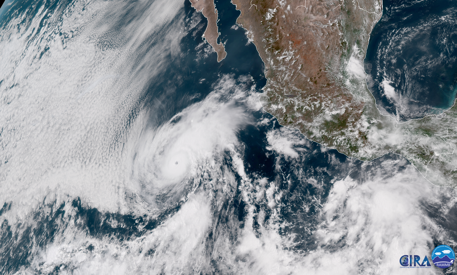
Hurricane Aletta was the perfect hurricane to admire on satellite imagery without a pang of guilt. Most of the storms that form in the eastern Pacific are great to gawk at because, for the most part, they form near Mexico and swirl west without ever affecting so much as shipping lanes let alone populated areas. A storm like Bud, on the other hand, is more problematic.

We routinely ignore the eastern Pacific’s tropical cyclones in the United States because they rarely affect us, but the basin can occasionally spin up devastating storms for western Mexico. 2015 saw the strongest hurricane ever recorded in Hurricane Patricia—the storm packed maximum sustained winds of 215 MPH (really!) before weakening to “only” a borderline category five storm at landfall. The worst of Hurricane Odile‘s category three winds devastated Cabo San Lucas when the storm came ashore in September 2014.

Hurricane season is fully underway in both oceans that surround the United States and Central America. I published a hurricane season primer last week to help you know what to expect this summer and how to keep track of all the forecasts and products issued when a storm forms.

[Satellite: CIRA/RAMMB | Maps: Dennis Mersereau]


Please consider subscribing to my writing on Patreon. Reader-funded journalism is more important than ever and your support helps fund engaging, hype-free weather coverage.

Author

Dennis Mersereau

I have 15+ of experience providing hype-free weather information for folks across the United States and around the world. In addition to DAMWeather, I also contribute to The Weather Network as a digital writer and weather specialist.

Follow Me
Other Articles
Previous

Here’s a Hype-Free Rundown to Help You Keep Track of Storms This Hurricane Season

Next

Bud Could Bring Rain to the Parched Desert Southwest This Weekend


Local ◈ UTC
Facebook | Bluesky
Instagram | Threads | Email
DAMWeather is now ad-free! Everyone benefits from engaging, hype-free weather coverage. Please consider supporting my efforts through Patreon:


Order The Skies Above today!

Bookshop.org || Barnes & Noble
Mountaineers Books || Amazon

My latest book, The Skies Above, is now available!

Did you know a puffy cloud can weigh millions of pounds? Or that every rainbow you see is unique to you?

Our atmosphere is full of spectacular sights that are always within your reach. Glistening layers of fog, gorgeous sunsets, and brilliant meteors flashing through the sky can light up even the calmest day.

The Skies Above, published by Mountaineers Books, is a celebration of what we overlook when we look up. I was thrilled to work with the editors and illustrators at Indelible Editions to share with you the quotidian beauty of our sky.

Order your copy now and learn about the wonders we take for granted every day.

I teamed up with the editors of Outdoor Life magazine to write The Extreme Weather Survival Manual, your guide to surviving and thriving in almost any weather condition. Whether you're an avid outdoorsperson or you enjoy watching the radar from the comfort of your home, you're sure to find helpful tips, advice, and new bits of knowledge in this fascinating book.

You can buy my book today through Amazon.
  • 2026 (34)
  • 2025 (49)
  • 2024 (59)
  • 2023 (43)
  • 2022 (57)
  • 2021 (71)
  • 2020 (83)
  • 2019 (88)
  • 2018 (92)
  • 2017 (1)
  • 2016 (4)
  • 2015 (10)

Copyright 2026 — DAMWeather. All rights reserved. Blogsy WordPress Theme