Skip to content
DAMWeather DAMWeather DAMWeather

The weather can get scary. Reporting on it doesn't have to be.

DAMWeather DAMWeather DAMWeather

The weather can get scary. Reporting on it doesn't have to be.

  • About Me
  • All Bylines
    • Books, Bylines, and Press
    • The Skies Above (Book)
    • Extreme Weather (Book)
    • The Weather Network
    • The Vane
    • Forbes
    • Capital Weather Gang
    • Mental Floss
  • Maps
    • Hurricane Maps
    • Hurricane Names
    • Monthly Tornadoes
    • Tornado Tracks
    • F5/EF-5 Tornadoes
    • SPC High Risk Days
  • GIS Resources
  • Contact Me
    • Bluesky
    • Facebook
    • Instagram
  • wxdam.com
  • About Me
  • All Bylines
    • Books, Bylines, and Press
    • The Skies Above (Book)
    • Extreme Weather (Book)
    • The Weather Network
    • The Vane
    • Forbes
    • Capital Weather Gang
    • Mental Floss
  • Maps
    • Hurricane Maps
    • Hurricane Names
    • Monthly Tornadoes
    • Tornado Tracks
    • F5/EF-5 Tornadoes
    • SPC High Risk Days
  • GIS Resources
  • Contact Me
    • Bluesky
    • Facebook
    • Instagram
  • wxdam.com
Close

Search

Damaging Winds and Isolated Tornadoes Possible on the East Coast on Wednesday

By Dennis Mersereau
August 1, 2018 2 Min Read

A threat for severe weather will accompany thunderstorms that pop up east of the Appalachians this afternoon. The Storm Prediction Center has issued a slight risk for severe weather—a 2 on a scale from 1 to 5—due to the threat for damaging winds and an isolated risk for tornadoes and large hail. The threat shouldn’t be widespread, but any storm that develops could get strong in a hurry.

The eastern United States is deep in a gross weather pattern that just doesn’t want to go away. A strong Bermuda High over the western Atlantic is funneling rich tropical moisture as far north as the Canadian Maritimes. This is why the East Coast has been so unusually muggy and wet for the past couple of weeks.
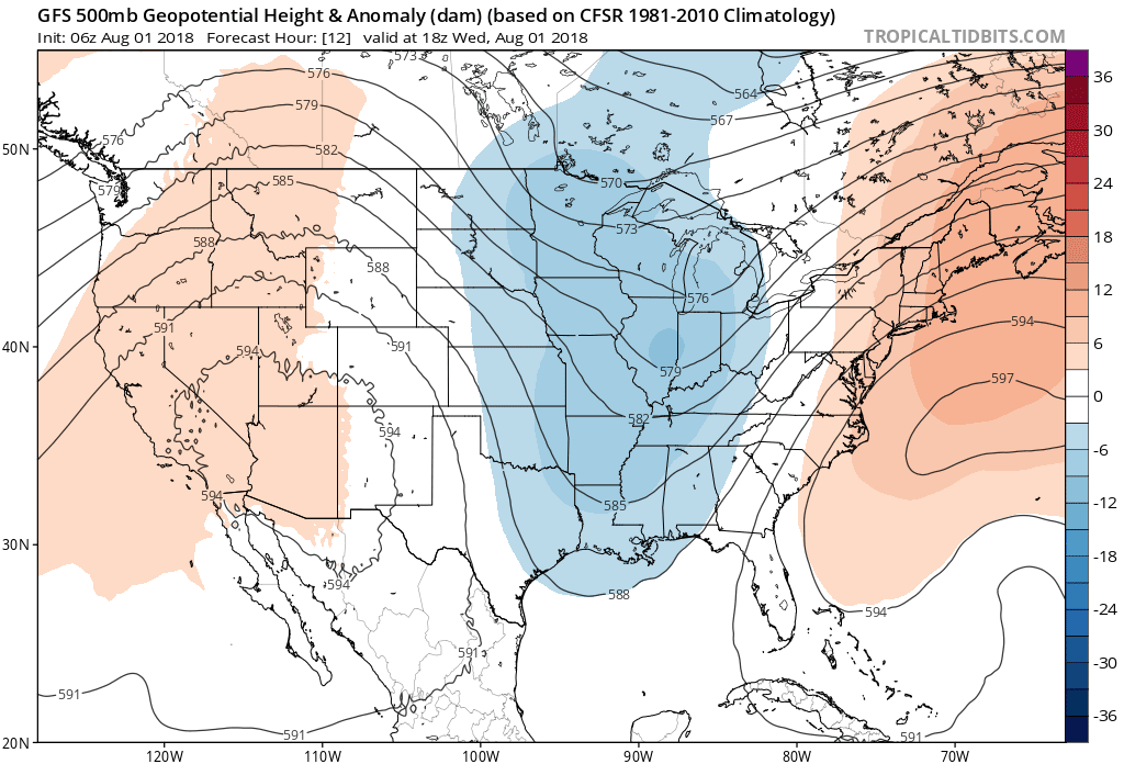
Source: Tropical Tidbits

A sharp trough stretching from the Great Lakes to the Gulf Coast on Wednesday will force thunderstorms to develop along and east of the Appalachian Mountains once daytime heating sufficiently destabilizes the atmosphere. There’s enough wind shear in the atmosphere that conditions are favorable for storms to organize into squall lines—where damaging winds would be the greatest threat—or even isolated supercells, where large hail and tornadoes could occur.

It’s not hard for thunderstorms in the middle of the summer to produce damaging wind gusts, especially in the southeastern United States where storms have ample moisture to work with. The severe weather threat today is exactly where you’d expect to see severe thunderstorms at the beginning of August.

Not only is there a risk for severe weather, but we can’t discount the threat for flash flooding where storms develop. Flash flood watches are in effect from the Alabama coast all the way up to northeastern Pennsylvania. This region has seen a lot of rain recently. Parts of Pennsylvania and Maryland saw more than a foot of rain last week. The combination of soggy ground and the potential for torrential rain in any storms that form will heighten the risk for flash flooding through the end of the week.

It’s a good idea to check your smartphone to make sure that emergency alerts are activated. People like to shut those off after one too many AMBER Alerts or flash flood warnings, but it’s really helpful when you’re out and about and a tornado warning is issued for your location.


You can follow me on Twitter or send me an email.

Please consider subscribing to my Patreon. Reader-funded news is more important than ever and your support helps fund engaging, hype-free weather coverage.
 

Author

Dennis Mersereau

I have 15+ of experience providing hype-free weather information for folks across the United States and around the world. In addition to DAMWeather, I also contribute to The Weather Network as a digital writer and weather specialist.

Follow Me
Other Articles
Previous

Oh, For Crying Out Loud, Please Not This Gross Weather Pattern Again

Next

Major Hurricane Hector Will Likely Pass South of Hawaii This Week


Local ◈ UTC
Facebook | Bluesky
Instagram | Threads | Email
DAMWeather is now ad-free! Everyone benefits from engaging, hype-free weather coverage. Please consider supporting my efforts through Patreon:


Order The Skies Above today!

Bookshop.org || Barnes & Noble
Mountaineers Books || Amazon

My latest book, The Skies Above, is now available!

Did you know a puffy cloud can weigh millions of pounds? Or that every rainbow you see is unique to you?

Our atmosphere is full of spectacular sights that are always within your reach. Glistening layers of fog, gorgeous sunsets, and brilliant meteors flashing through the sky can light up even the calmest day.

The Skies Above, published by Mountaineers Books, is a celebration of what we overlook when we look up. I was thrilled to work with the editors and illustrators at Indelible Editions to share with you the quotidian beauty of our sky.

Order your copy now and learn about the wonders we take for granted every day.

I teamed up with the editors of Outdoor Life magazine to write The Extreme Weather Survival Manual, your guide to surviving and thriving in almost any weather condition. Whether you're an avid outdoorsperson or you enjoy watching the radar from the comfort of your home, you're sure to find helpful tips, advice, and new bits of knowledge in this fascinating book.

You can buy my book today through Amazon.
  • 2026 (34)
  • 2025 (49)
  • 2024 (59)
  • 2023 (43)
  • 2022 (57)
  • 2021 (71)
  • 2020 (83)
  • 2019 (88)
  • 2018 (92)
  • 2017 (1)
  • 2016 (4)
  • 2015 (10)

Copyright 2026 — DAMWeather. All rights reserved. Blogsy WordPress Theme