Skip to content
DAMWeather DAMWeather DAMWeather

The weather can get scary. Reporting on it doesn't have to be.

DAMWeather DAMWeather DAMWeather

The weather can get scary. Reporting on it doesn't have to be.

  • About Me
  • All Bylines
    • Books, Bylines, and Press
    • The Skies Above (Book)
    • Extreme Weather (Book)
    • The Weather Network
    • The Vane
    • Forbes
    • Capital Weather Gang
    • Mental Floss
  • Maps
    • Hurricane Maps
    • Hurricane Names
    • Monthly Tornadoes
    • Tornado Tracks
    • F5/EF-5 Tornadoes
    • SPC High Risk Days
  • GIS Resources
  • Contact Me
    • Bluesky
    • Facebook
    • Instagram
  • wxdam.com
  • About Me
  • All Bylines
    • Books, Bylines, and Press
    • The Skies Above (Book)
    • Extreme Weather (Book)
    • The Weather Network
    • The Vane
    • Forbes
    • Capital Weather Gang
    • Mental Floss
  • Maps
    • Hurricane Maps
    • Hurricane Names
    • Monthly Tornadoes
    • Tornado Tracks
    • F5/EF-5 Tornadoes
    • SPC High Risk Days
  • GIS Resources
  • Contact Me
    • Bluesky
    • Facebook
    • Instagram
  • wxdam.com
Close

Search

An Early-Season Winter Storm Will Bring Snow and Ice to the Midwest and Eastern States

By Dennis Mersereau
November 14, 2018 3 Min Read

The raw chill that’s settled over the eastern half of the United States over the past couple of weeks set the stage for winter weather to follow closely behind. There’s a decent chance that many areas will see their first significant snow and ice storm between Wednesday and Friday, with the heaviest snow falling in the Midwest and Northeast, while freezing rain will coat much of the Appalachian Mountains in a crust of ice.

Our storm developing tonight comes fresh on the heels of a storm that brought heavy snow to the southern Plains and heavy rain to just about everyone else east of the Mississippi River. More than half a foot of snow fell in parts of Texas and Oklahoma as the system met cold air locked firmly in place over the region. Farther to the south on the warm side of the system, persistent heavy rains and thunderstorms led to flooding and even a couple of reported tornadoes in North Carolina.
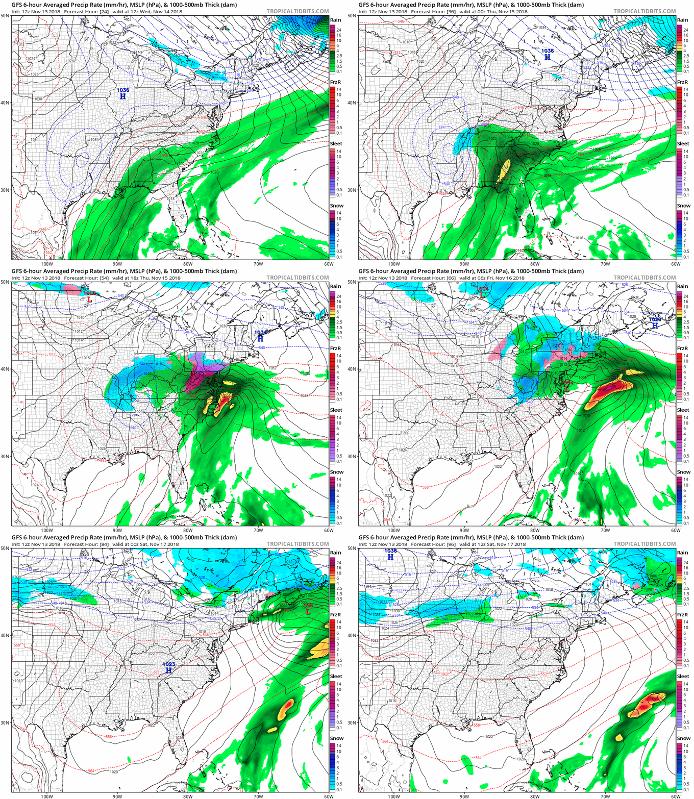
Source: Tropical Tidbits

That storm is out of here and the next one isn’t far behind. An upper-level low will develop over the Mississippi River valley on Wednesday and slowly make its way east over the following two days. The system will bulk up in a hurry as it moves east, producing yet another prolonged round of heavy precipitation along its path.

Snow

Cold air on the northern side of the system will allow precipitation to fall in the form of snow, sleet, and ice. The heavy snow will start falling in and around southern Illinois on Wednesday night and Thursday morning. Some areas could see more than half a foot of snow, though widespread shovelable totals will make it difficult to get around on Thursday.

Snow will be more widespread across the Ohio Valley, Great Lakes, and Northeast on Thursday and Friday. Many areas west of I-95 are on track to see several inches of snow, with much higher totals in higher elevations and where lake effect snow enhances snowfall totals. It won’t take much for the rain/snow/ice line to shift a dozen miles to the east or west, so if you live right on that line between nothing and something, it’s wise to watch the forecasts and make sure you’re ready with the ice scraper or snowbrush just in case.

Ice

Temperatures hovering right around freezing with above-freezing temperatures above the surface will allow for freezing rain and sleet to fall in the Appalachians and parts of the Mid-Atlantic. The most significant ice accretion will occur in the Appalachians, where one-quarter of an inch or more of ice is possible on exposed surfaces.

1/4″ of ice doesn’t seem like much, but that’s a lot of weight on power lines and tree limbs, and it could lead to downed trees and power outages in some areas. The ice will also make travel difficult or impossible for a time on Thursday until temperatures climb back above freezing.


You can follow me on Twitter or send me an email.

Please consider subscribing to my Patreon. Reader-funded news is more important than ever and your support helps fund engaging, hype-free weather coverage.
 

Author

Dennis Mersereau

I have 15+ of experience providing hype-free weather information for folks across the United States and around the world. In addition to DAMWeather, I also contribute to The Weather Network as a digital writer and weather specialist.

Follow Me
Other Articles
Previous

Nighttime Severe Thunderstorms and Tornadoes Are Likely Tonight in the South

Next

Florida Will Participate In Autumn If It’s The Last Thing The Other 47 States Do, So Help Us


Local ◈ UTC
Facebook | Bluesky
Instagram | Threads | Email
DAMWeather is now ad-free! Everyone benefits from engaging, hype-free weather coverage. Please consider supporting my efforts through Patreon:


Order The Skies Above today!

Bookshop.org || Barnes & Noble
Mountaineers Books || Amazon

My latest book, The Skies Above, is now available!

Did you know a puffy cloud can weigh millions of pounds? Or that every rainbow you see is unique to you?

Our atmosphere is full of spectacular sights that are always within your reach. Glistening layers of fog, gorgeous sunsets, and brilliant meteors flashing through the sky can light up even the calmest day.

The Skies Above, published by Mountaineers Books, is a celebration of what we overlook when we look up. I was thrilled to work with the editors and illustrators at Indelible Editions to share with you the quotidian beauty of our sky.

Order your copy now and learn about the wonders we take for granted every day.

I teamed up with the editors of Outdoor Life magazine to write The Extreme Weather Survival Manual, your guide to surviving and thriving in almost any weather condition. Whether you're an avid outdoorsperson or you enjoy watching the radar from the comfort of your home, you're sure to find helpful tips, advice, and new bits of knowledge in this fascinating book.

You can buy my book today through Amazon.
  • 2026 (34)
  • 2025 (49)
  • 2024 (59)
  • 2023 (43)
  • 2022 (57)
  • 2021 (71)
  • 2020 (83)
  • 2019 (88)
  • 2018 (92)
  • 2017 (1)
  • 2016 (4)
  • 2015 (10)

Copyright 2026 — DAMWeather. All rights reserved. Blogsy WordPress Theme