This Week’s Major Storm Will Plaster The Northern Plains With Up To Two Feet Of Snow

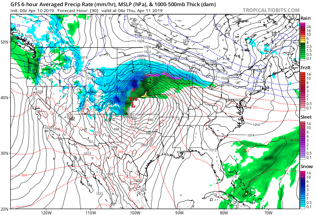
A wet, wind-driven snow will plaster the Plains and Upper Midwest this week as another memorable springtime winter storm rapidly spins-up over the center of the country. The storm—not too dissimilar from the major storm we saw this time last month—will produce everything from a historic -for-April blizzard up north to extreme fire conditions in the Southwest.
The storm will kick into gear on Wednesday as the lift from an upper-level trough crossing the Rockies coincides with the lift from strong winds in the jet stream over the southern Plains. Just like we saw last month, this storm should ramp up in a hurry, undergoing bombogenesis during the day on Wednesday as it crosses from eastern Colorado through central Kansas.
We could see another round of record-low air pressure readings for the month of April if the low’s minimum central pressure deepens as much as current forecasts suggest. The current all-time low air pressure readings for the month of April stand between 977-980 mb across the region where the low will grow its strongest, which is right around the predicted minimum pressure for this storm.
Snow
 |
| A map of storm total snowfall predicted by local NWS offices, issued Tuesday evening. |
This will be a significant and disruptive snowstorm for a large swath of land between Colorado and Ontario. Precipitation will fall in the form of snow across most of the northern expanse of the storm, likely producing more than a foot of snow from central Nebraska through to the western shores of Lake Superior. Communities looking at 12″+ of snow include Rapid City, Pierre, St. Cloud, and Duluth.
Timing: Snow is already falling across parts of the central Rockies tonight. Wintry precip will quickly pick up in coverage and intensity on Wednesday morning as the storm develops and strengthens. A blizzard warning is in effect for the Denver metro area from noon Wednesday until noon Thursday. The heavy snow will overspread the northern Plains and Upper Midwest on Wednesday night and continue through Friday morning, gradually ending from west to east.
Amounts: A sharp temperature gradient along the track of the storm, both at the surface and aloft, will mean there’s a sharp cutoff between significant snowfall totals and not much of anything at all. This is a particularly unnerving scenario because Sioux Falls, Minneapolis, and St. Paul are all straddling that line between a nuisance snowfall and a crippling blizzard. Any southward jog in the track of the storm will force the heavy, sustained snowfall farther to the south and into the heart of these cities.
Some communities will see monthly snowfall records from this system. The most snow ever recorded during the month of April in Pierre, South Dakota, was 13.4″ during the April of 1986. This storm could top that. The most snow recorded for the month of April in Duluth, Minnesota, was 12.7″ set back in…well, last year. The latest NWS forecast shows this storm easily topping that with close to a foot-and-a-half of snow.
Flooding

The big story with last month’s storm wound up being the immense flooding that engulfed entire towns in the days and weeks after the storm. Major flooding is likely after this storm, as well, though probably not on the scale we saw last time around.
The snow that falls this week will be heavy and wet. The latest precipitation forecast from the Weather Prediction Center shows 3-4″ of liquid-equivalent precipitation falling across the hardest-hit flood areas through the end of the week.
 |
| River flooding forecast from the NWS through the next week. (NWS) |
Once the snow starts to melt, many rivers will again begin to overflow their banks and lead to major flooding in the surrounding areas. Several rivers in the region are already at moderate or major flood stage.
The National Weather Service expects most gauges along the Red River in North Dakota, James River and Big Sioux River in South Dakota, the Mississippi River from Minnesota on down, and many other smaller waterways in the region to experience moderate or major flooding in the next week because of the impending surge of rain and snow.
The situation shouldn’t be quite as severe as we saw last month—only minor and moderate flooding is in the forecast in Nebraska—as the bulk of the precipitation will be farther north than it was in March and the ground isn’t frozen anymore. The frozen, impermeable ground, along with forced the vast majority of the water to run off into waterways, exacerbating the flooding.
Severe Weather

Not only will the impending satellite images tomorrow grab the attention of weather nerds, but it’s likely that a temperature map will also look pretty impressive during the day’s peak heating. Only a short drive will separate seeing your breath from sweating to death. (Okay, well maybe not sweating that much, but “kinda sweating” doesn’t rhyme.)

As you’d expect to see with any strong storm system and that kind of temperature gradient, there’s a chance for severe thunderstorms along the storm’s track on Wednesday. The dynamics aren’t the greatest due to the relative lack of moisture accompanying the warmth, but conditions will be favorable for severe thunderstorms with the risk of large hail and some damaging winds. An isolated tornado or two is possible in a situation like this, the best chance for which would be right around the warm front.
The chance for severe weather will shift to the other side of the Mississippi River on Thursday afternoon, where severe thunderstorms that develop along the advancing cold front could bring damaging wind gusts to parts of eastern Illinois and western Indiana.
High Winds
A strong storm wrapping up on flat land is a recipe for high winds. (I think I typed that exact sentence with the last one, come to think of it.) High wind warnings and wind advisories are up for much of the Southwest and southern Plains in anticipation for wind gusts of 60-70 MPH when the storm cranks up during the day on Wednesday. The combination of high winds, dry air, and warm temperatures will lead to a high fire risk across parts of New Mexico and far western Texas during the day on Wednesday.
[Top Image: Tropical Tidbits]
Please consider subscribing to my Patreon. Reader-funded news is more important than ever and your support helps fund engaging, hype-free weather coverage.