Skip to content
DAMWeather DAMWeather DAMWeather

The weather can get scary. Reporting on it doesn't have to be.

DAMWeather DAMWeather DAMWeather

The weather can get scary. Reporting on it doesn't have to be.

  • About Me
  • All Bylines
    • Books, Bylines, and Press
    • The Skies Above (Book)
    • Extreme Weather (Book)
    • The Weather Network
    • The Vane
    • Forbes
    • Capital Weather Gang
    • Mental Floss
  • Maps
    • Hurricane Maps
    • Hurricane Names
    • Monthly Tornadoes
    • Tornado Tracks
    • F5/EF-5 Tornadoes
    • SPC High Risk Days
  • GIS Resources
  • Contact Me
    • Bluesky
    • Facebook
    • Instagram
  • wxdam.com
  • About Me
  • All Bylines
    • Books, Bylines, and Press
    • The Skies Above (Book)
    • Extreme Weather (Book)
    • The Weather Network
    • The Vane
    • Forbes
    • Capital Weather Gang
    • Mental Floss
  • Maps
    • Hurricane Maps
    • Hurricane Names
    • Monthly Tornadoes
    • Tornado Tracks
    • F5/EF-5 Tornadoes
    • SPC High Risk Days
  • GIS Resources
  • Contact Me
    • Bluesky
    • Facebook
    • Instagram
  • wxdam.com
Close

Search

Parts Of Southern Georgia Saw 7 Inches Of Rain In Just Three Hours On Tuesday

By Dennis Mersereau
June 12, 2019 3 Min Read

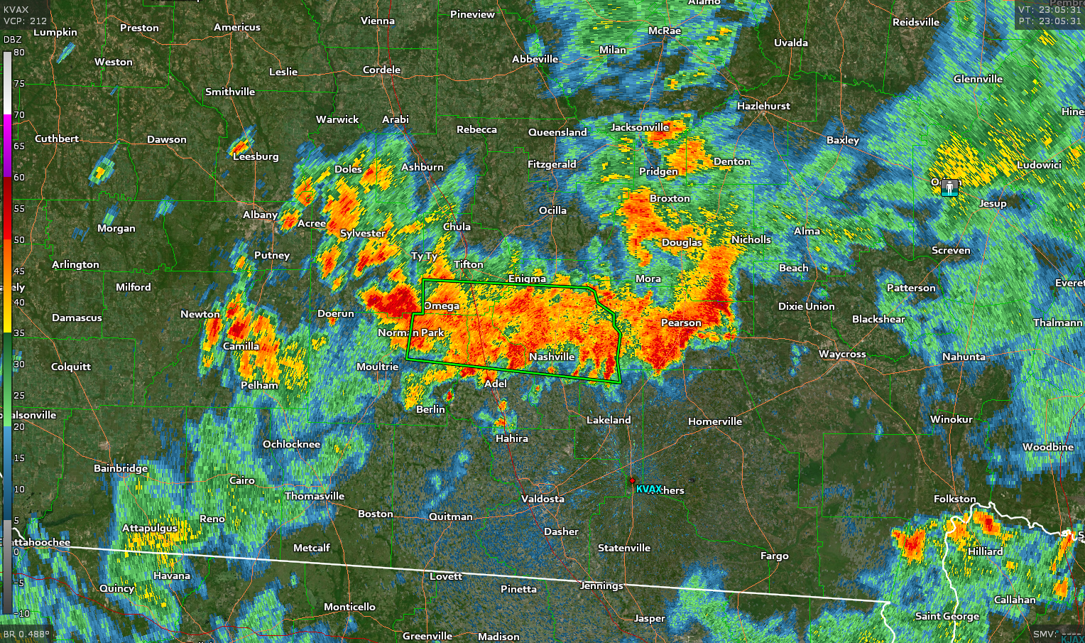
A large cluster of thunderstorms that popped up in southern Georgia on Tuesday evening produced more than 7.00 inches of rain in just a couple of hours, prompting a flash flood warning as local waterways and storm sewers were inundated by the abrupt surge of water. The sudden nature of the storms highlights the flooding risk that summertime thunderstorms can pose in the moisture-laden southeastern United States.

Folks who live in the southeast are no strangers to a drenching afternoon thunderstorm. It’s not uncommon for a thunderstorm to pop up and drop a quick inch or two of rain before moving on an hour later. The storms north of Valdosta, Georgia, however, are an example of how quickly things can get serious when your run-of-the-mill summertime thunderstorms sit in the same spot for too long.
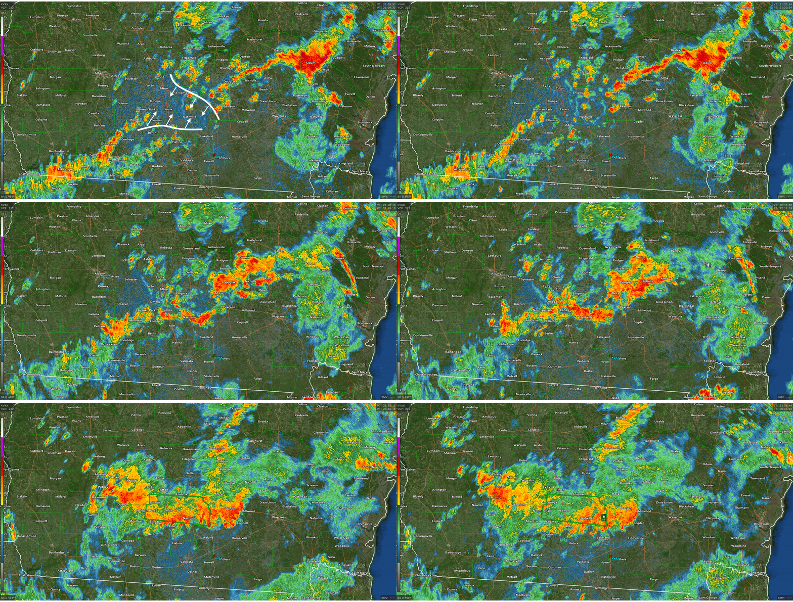
The cluster of thunderstorms that put down the torrential rain were the result of converging outflow boundaries. An outflow boundary is the rush of cool air that descends out and away from a thunderstorm. Outflow boundaries often act like little cold fronts that scoop up unstable air ahead of them and trigger the development of more thunderstorms as the afternoon wears on. This domino effect can continue until the unstable air is exhausted—usually around sunset.

Outflow boundaries were responsible for the flooding rains over southern Georgia on Tuesday. Imagery from the Valdosta radar showed multiple outflow boundaries colliding almost head-on across the counties north of Valdosta. A cluster of thunderstorms bloomed when the boundaries collided and the unstable air had nowhere to go but straight up.

Radar-estimated rainfall amounts on Tuesday evening. Source: GREarth/AllisonHouse

Since there weren’t any prevailing boundaries or strong steering currents to drive the storms out of the area, they just sat and poured over the same communities for several hours at a time as they very slowly drifted toward the south. A weather spotter near Weber, Georgia, reported 5.81 inches of rain
between 5:54 PM and 7:54 PM. NWS Tallahassee reported on Twitter that one community—possibly that same weather spotter—saw more than 7.00 inches of rain by the time the storm wound down. Radar estimates indicate that several counties saw 5-7 inches of rain during the storm.

The Weather Prediction Center warns that there’s a chance for more flash flooding across coastal sections of Georgia, South Carolina, and southeastern North Carolina on Wednesday. It’s hard to say who will see the heaviest rains, but any thunderstorms that pop up in the region have the potential to produce lots of heavy rain in a short period of time.

[Radar Imagery: GR2A/Gibson Ridge]


You can follow me on Twitter or send me an email.

Please consider subscribing to my Patreon. Your support helps me write engaging, hype-free weather coverage—no fretting over ad revenue, no chasing viral clicks. Just the weather.
 

Author

Dennis Mersereau

I have 15+ of experience providing hype-free weather information for folks across the United States and around the world. In addition to DAMWeather, I also contribute to The Weather Network as a digital writer and weather specialist.

Follow Me
Other Articles
Previous

Typically-Comfy San Francisco Hits 100°F As West Coast Heat Wave Continues This Week

Next

Here's a Look at CAPE, the Fuel That Powers Thunderstorms


Local ◈ UTC
Facebook | Bluesky
Instagram | Threads | Email
DAMWeather is now ad-free! Everyone benefits from engaging, hype-free weather coverage. Please consider supporting my efforts through Patreon:


Order The Skies Above today!

Bookshop.org || Barnes & Noble
Mountaineers Books || Amazon

My latest book, The Skies Above, is now available!

Did you know a puffy cloud can weigh millions of pounds? Or that every rainbow you see is unique to you?

Our atmosphere is full of spectacular sights that are always within your reach. Glistening layers of fog, gorgeous sunsets, and brilliant meteors flashing through the sky can light up even the calmest day.

The Skies Above, published by Mountaineers Books, is a celebration of what we overlook when we look up. I was thrilled to work with the editors and illustrators at Indelible Editions to share with you the quotidian beauty of our sky.

Order your copy now and learn about the wonders we take for granted every day.

I teamed up with the editors of Outdoor Life magazine to write The Extreme Weather Survival Manual, your guide to surviving and thriving in almost any weather condition. Whether you're an avid outdoorsperson or you enjoy watching the radar from the comfort of your home, you're sure to find helpful tips, advice, and new bits of knowledge in this fascinating book.

You can buy my book today through Amazon.
  • 2026 (34)
  • 2025 (49)
  • 2024 (59)
  • 2023 (43)
  • 2022 (57)
  • 2021 (71)
  • 2020 (83)
  • 2019 (88)
  • 2018 (92)
  • 2017 (1)
  • 2016 (4)
  • 2015 (10)

Copyright 2026 — DAMWeather. All rights reserved. Blogsy WordPress Theme