Summer Is Squall Line Season In The United States—Here’s How These Storms Form

It’s squall line season in the United States. The majority of the exciting weather we’ll see over the next couple of months will come from these lines of storms that bubble up and race across hundreds of miles in one shot. We see lots of interesting severe weather in this country, but squall lines—often referred to as mesoscale convective systems (MCS)—are impressive both for their strength and sheer resilience. Here’s a look at how these fascinating systems develop.
Not all thunderstorms are the same. They may share similar features, sure, but their structures can be very different and it’s that structure that determines their fate.
Single-Cell Thunderstorms

Single-cell thunderstorms are far and away the most common storms out there. They begin with a single updraft and dissipate when the downdraft of cool air chokes off the storm’s access to instability. The above radar image shows single-cell storms bubbling across central Alabama on a hot summer afternoon in 2015.
Supercells

Supercell thunderstorms get top billing when it comes to severe weather—and for good reason. Supercells feature rotating updrafts that can power a single thunderstorm for hours. The structure of a supercell can produce strong tornadoes, enormous hail, and very strong winds. The classic supercell above produced the infamous F5 tornado that hit Moore, Oklahoma, on May 3, 1999.
Multicell Thunderstorms

And then there are multicell thunderstorms, which are complexes of thunderstorms that are all linked to one another. The interconnected nature of multicell convection can keep these storms going for hours, leading to a threat of destructive winds or flash flooding (or both!). A cluster of storms that merge into a well-developed line of storms—like the one above from last summer—is a mesoscale convective system (MCS). The terms MCS and squall line are interchangeable.
A strong and long-lived MCS that produces wind damage over a path of about 250 miles or longer is known as a derecho. The above MCS last summer was a derecho…in fact, one of three derechos that formed that day. That word can whip-up fear in a flash after the bad derecho of 2012. Lots of meteorologists—fully aware of the fear factor involved—hesitate to use the term now, and some even get angry when others use it. However, it’s a valid meteorological term, and it’s perfectly fine to use when a storm meets the criteria.
The July 11, 2011 Derecho

My favorite example of an MCS is the central Iowa derecho of July 11, 2011, because we got such a detailed view of the structure of this storm on the Des Moines radar. I’ve mentioned this storm in passing in some past explainers I’ve written on derechos (links here and here).
The bow echo pattern on radar imagery is often a sign of strong winds…an understatement in this case, as it turns out. The above image shows the storm just as it’s starting to produce a wide swath of straight-line winds in excess of 100 MPH. The white line through the middle of the storms is the cross-section I use in the images that follow.

The storm that tore through central Iowa started out as a couple of run-of-the-mill thunderstorms west of Omaha, Nebraska. Just about every MCS starts as a handful of separate thunderstorms.
Thunderstorms breathe in warm, unstable air and exhale cool, stable air. This outflow of stable air beneath a storm causes cold air to pool up at the surface. This cold pool spreads out from the parent thunderstorm like a ripple on a pond. The leading edge of a cold pool, called an outflow boundary, acts like a mini cold front as it scoops up unstable air and triggers new thunderstorm activity.
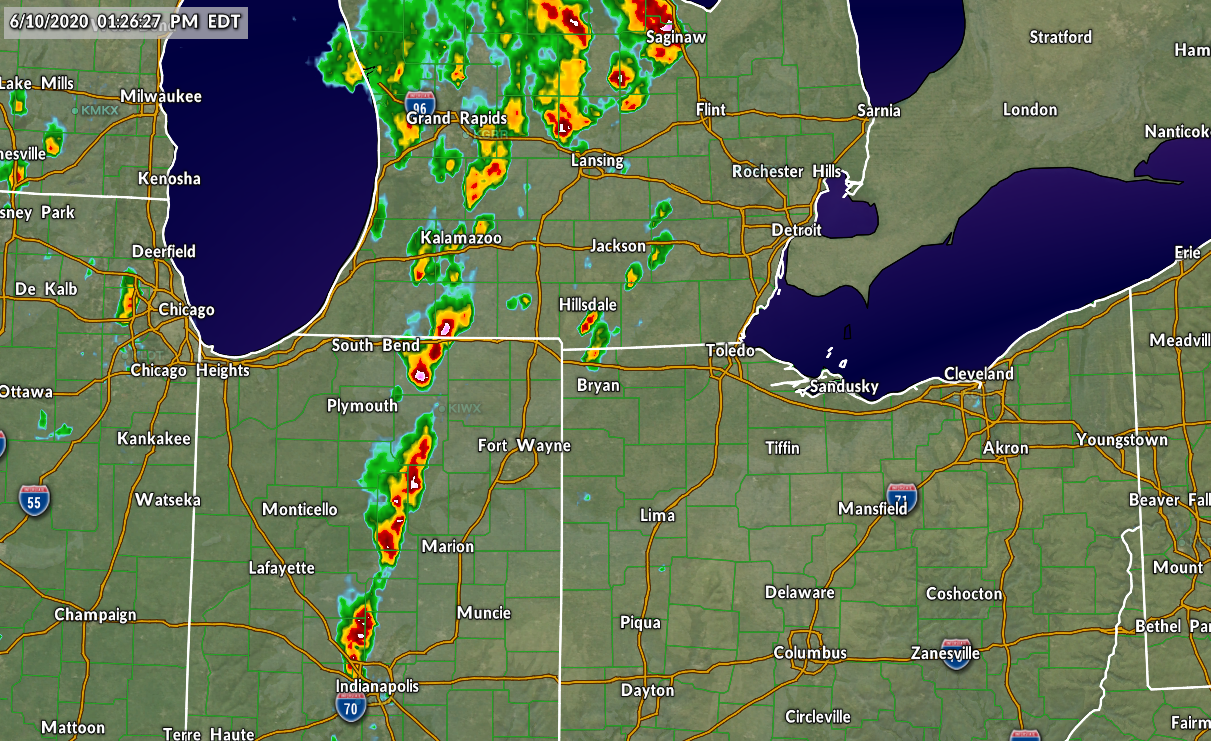
If thunderstorms form close enough together, their cold pools can merge into one entity. This merger causes the thunderstorms to become interconnected, moving and strengthening in unison. The thunderstorms latch on to the leading edge of that cold pool, forming into a line as they begin to race downwind.

The forward motion of the newly-minted line of storms causes their updrafts to tilt backwards, allowing unstable air to get scooped directly into the thunderstorms. This structure allows the storms to consume unstable air without getting choked off by the stable air beneath them.
The radar cross-section above shows the winds throughout the MCS just as it’s starting to produce those 100 MPH straight-line winds. The image is oriented so that southwest is on the left and northeast is on the right. Des Moines is just off-screen to the left. The green colors show wind blowing southwest toward the radar, while the warmer colors show wind blowing northeast away from the radar.

You can see the tilted updraft on radar, clear as day. The cold pool at the surface is lifting up all that unstable air over central Iowa and feeding it right into those storms.

Friction begins to take its toll on the cold pool after a while. We wind up seeing lots of horizontal and vertical rolling motions within an MCS due to friction between the moving air, the calmer air around the storm, and the ground below. It’s kinda like the little whirls that form in a swimming pool when you run your hand through the water.
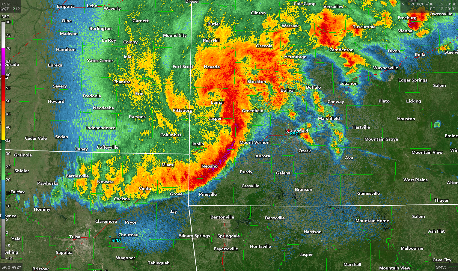
You can’t really see the horizontal rotation (diagrammed above) on radar, but the vertical rotation shows up as those little curly ends on the edges of squall lines. These curls are known as “bookend vortices.” This storm had a pretty hefty bookend vortex, but it’s hard to see on radar. These features are exceptionally pronounced in some squall lines, like the May 8, 2009, derecho depicted at the very top of this post.

These friction-induced areas of rotation create a feature known as a “rear inflow jet” that feeds air into the front of the storm. It’s the rear inflow jet that creates the powerful straight-line winds in a squall line. The rear inflow jet roars from the back of the storm to the front, getting shoved into the ground by the thunderstorms along the leading edge of the squall line. In stronger squall lines, the abrupt onset of violent winds is partially why people remember these storms so well.
Death of an MCS
Not all squall lines are powerhouses of doom. Most of them remain below severe levels and only produce a breezy rain. But whether it’s the strongest storm in living memory or one that no one will ever remember, they all have one last thing in common—they must die.
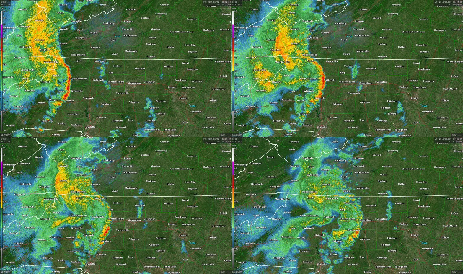
There are two main ways a squall line can die. The first is that they can run out of instability and just gently power down like a toy when its batteries start to fail. The above animation shows a squall line slowly losing power as it survives crossing the North Carolina mountains only to find an environment with absolutely no instability.
The second cause of death is when the cold pool outruns the thunderstorms, which is much more interesting to watch on radar and experience in person. Thunderstorms have to keep up with the leading edge of the cold pool in order to maintain their strength and keep rolling along. After all, the storms are relying on the cold pool to feed them that instability.
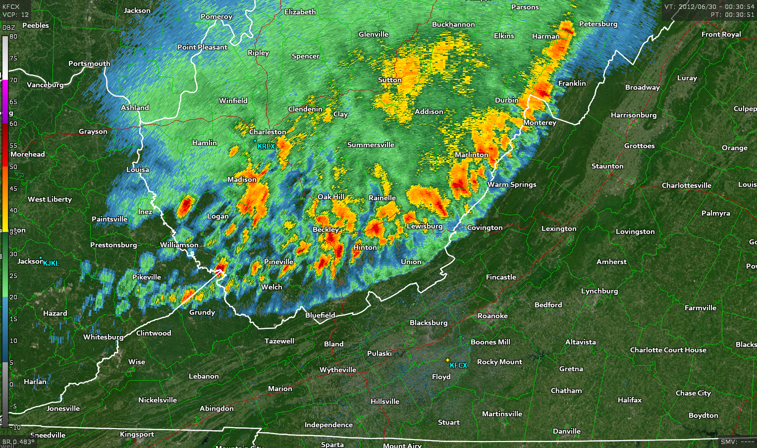
If the storms start to fall behind, it gets harder and harder for them to ingest the unstable air they need to survive. Eventually, the cold air runs too far ahead and the storms choke and start to dissipate. This process can sometimes happen very quickly. The remnant outflow can serve as the focus for more storm development the following day.
The southern end of the June 29, 2012, derecho (above) is a great example of the cold pool far outrunning its thunderstorms. The outflow boundary is the thin green line a dozen or so miles ahead of the thunderstorms. This derecho was so strong, though, that the outflow boundary continued to produce 60+ MPH winds deep into North Carolina. Some folks lost all the trees in their yard long before it even started raining.
Focus…

The most common spot to see an MCS develop is along a sharp boundary. The outer edge of a heat-wave-producing ridge of high pressure, often called a “ring of fire,” is a common track for a strong MCS to develop during the summer months. Stationary fronts, old outflow boundaries, and sharp instability gradients are all breeding grounds for MCS development.
The map above shows radar imagery superimposed over a temperature map. Remember I mentioned earlier that three derechos formed in one day last summer? The map above shows a radar image of those storms in progress, superimposed over a temperature map at the same time. You can see the storms riding along the heat ridge parked over the southern United States at the time.
[all radar images taken with Gibson Ridge’s GR2Analyst]
Please consider subscribing to my Patreon. Your support helps me write engaging, hype-free weather coverage—no fretting over ad revenue, no chasing viral clicks. Just the weather.