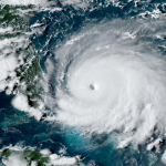
Hurricane Warnings Issued For Nova Scotia As Hurricane Dorian Races Toward Canada


Nova Scotia will likely experience hurricane conditions on Saturday as Hurricane Dorian makes its final run as a named storm. Tropical storm conditions are likely in Prince Edward Island, eastern New Brunswick, and western Newfoundland before the hurricane races toward the Arctic and dissipates.
Hurricane Dorian made landfall on Cape Hatteras, North Carolina, early on Friday morning, bringing hurricane force winds and a major flooding to the state’s Outer Banks. Some communities on the barrier islands recorded a significant storm surge, which was enough to inundate neighborhoods and cover roads in feet of sand and debris.

The hurricane continues to accelerate through the western Atlantic Ocean this evening as a trough over the northeastern U.S. scoops the storm toward higher latitudes. At 8:00 PM EDT, Hurricane Dorian still had formidable maximum sustained winds of 90 MPH with higher gusts.
A tropical storm warning is in effect for Cape Cod, Martha’s Vineyard, and Nantucket as the storm passes off to the east. Heavy rain and wind gusts as high as 60 MPH are possible through Saturday morning as Dorian passes well to the east of the area.
Dorian will begin to affect Nova Scotia on Saturday morning, with conditions quickly deteriorating through the afternoon hours. A hurricane warning is in effect for central and northern Nova Scotia. A tropical storm warning and a hurricane watch are in effect for southern Nova Scotia and Prince Edward Island. Hurricane and tropical storm watches are in effect for western portions of Newfoundland.
The greatest risk for hurricane force winds (119+ km/h, or 74+ MPH) will occur around the center of the storm, likely bringing a period of dangerous conditions to central and northern Nova Scotia as well as eastern Prince Edward Island, including the cities of Halifax, NS, and Charlottetown, PEI. Widespread power outages and tree damage are possible in these areas. Soggy soil from heavy rain could make trees more susceptible to toppling in the strong winds.
Environment Canada warns of the potential for 50-100 mm [2-4 in.] of rain in Nova Scotia and Prince Edward Island, where some totals could reach as high as 150 mm [6 in.]. This much heavy rain in a short period of time could lead to flash flooding in low-lying areas. The National Weather Service’s flood safety motto is “turn around, don’t drown.” It takes a surprisingly small amount of moving water for a vehicle to lose buoyancy and get washed downstream, and you can’t reliably tell how much water actually covers the road ahead of you.
It’s worth noting that the 5:00 PM forecast from the NHC keeps Hurricane Dorian a tropical cyclone as it crosses the Maritimes. Hurricane Dorian could soon undergo a process called “extratropical transition.” After this occurs, the storm will be called “Post-Tropical Cyclone Dorian” in official forecasts and warnings. Don’t let the new title throw you. It’ll still be the same storm with the same hazards.
Extratropical transition has to do with the internal structure of the storm. Tropical cyclones are fueled by thunderstorms around the center of circulation. Tropical cyclones racing toward higher latitudes often lose that energy source and begin to derive their energy from the jet stream instead. This causes the tropical cyclone to become an extratropical cyclone, or the type of low-pressure system that develops cold and warm fronts. A storm’s wind field grows larger as it undergoes extratropical
transition. This would expose more of Atlantic Canada to damaging winds.
Dorian will remain a dangerous storm even after it experiences this structural change. As such, the National Hurricane Center will continue to issue forecasts, watches, and warnings as they are now, so long as the storm poses a threat to land.
[Satellite: NOAA]
Please consider subscribing to my Patreon. Your support helps me write engaging, hype-free weather coverage—no fretting over ad revenue, no chasing viral clicks. Just the weather.