Life-Threatening Storm Surge & Wind Damage Likely As Hurricane Dorian Hits Carolinas

The core of Hurricane Dorian will come perilously close to the South Carolina and North Carolina coasts over the next 48 hours, potentially generating a life-threatening storm surge, widespread power outages, wind damage, and flash flooding from heavy rain. These areas will likely experience significant impacts from the storm whether or not the eye makes landfall.
The latest forecast from the National Hurricane Center, which was not
drawn with a sharpie, shows the center of the storm tracking along the
southeast coast through Friday afternoon. The storm will race toward Atlantic Canada this weekend, where several provinces could experience hurricane conditions.
 |
| Visible satellite imagery of Hurricane Dorian on September 4, 2019. | College of DuPage |
Hurricane Dorian remains a strong hurricane this evening, packing maximum sustained winds of 110 MPH with higher gusts. This is a healthy hurricane and it managed to strengthen a bit this afternoon, and there’s a chance it could strengthen into a major hurricane again as it passes over the Gulf Stream. Don’t pay too much attention to fluctuations in maximum sustained winds over the next couple of days. Hurricane Dorian is a dangerous storm with wide-ranging effects for folks along the coast and for several counties inland.
Storm Surge
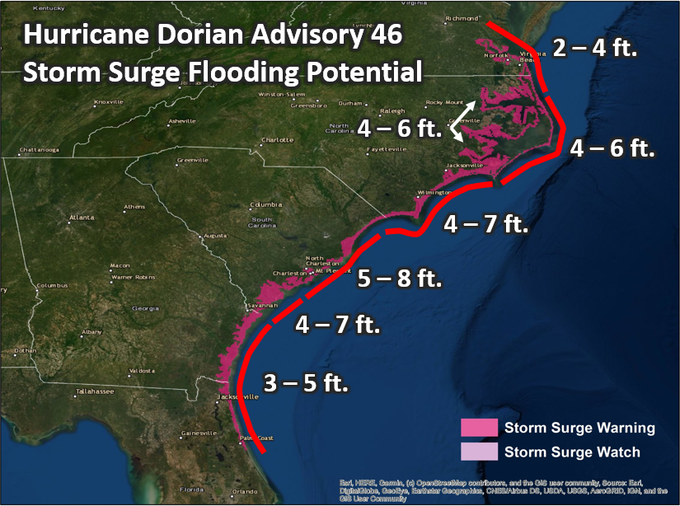 |
| NHC’s surge forecast on September 4, 2019. | Twitter/@NHC_Atlantic |
The most pressing concern right now is a life-threatening storm surge along the coast between northeastern Florida and the southern Virginia Tidewater. This is a long stretch of coast that could experience a significant storm surge between now and Friday.
A storm surge of 5 to 8 feet above normal tide levels is possible on the central South Carolina coast, including the Charleston and Myrtle Beach areas. That type of storm surge is deep enough to inundate the first floor of buildings along the coast, posing a serious threat to the lives of those who couldn’t or wouldn’t evacuate.
There are so many different surge forecasts for the coast that it’s a bit daunting in text form, so the National Hurricane Center tweeted out a handy map of possible surge heights this morning. It’s critical to heed evacuation orders in these areas.
Flooding Rains

Hurricane Dorian could produce rainfall totals of 5-10+ inches of rain across eastern parts of South Carolina and North Carolina through Friday. This much rain in a short period of time will likely lead to widespread flash flooding. The Weather Prediction Center shows the possibility of double-digit rainfall totals near the coast, including Charleston and Wilmington.
The vast majority of fatalities in landfalling tropical cyclones in recent years were the result of freshwater flooding. It’s nearly impossible to judge water depth on a flooded roadway until it’s too late. Find an alternate route if you know the roads ahead of you are susceptible to flooding.
Winds

The storm’s wind field has grown since
yesterday. Dorian’s hurricane force winds now extend 70 miles from the
center of the storm, with tropical storm force winds possible 175 miles
from the center of the storm. A larger wind field will expose more communities to the
storm’s hazards, including the risk for widespread power outages and
downed trees.
Hurricane warnings are in effect for
all coastal counties in South Carolina and North Carolina. Areas under a
hurricane warning could see sustained hurricane force winds over the
next two days, as well as a significant storm surge along the coast and
flash flooding from heavy rain.
Tropical storm warnings
are in effect for northeastern Florida and counties in eastern Georgia
on the south side of the storm, and for southeastern Virginia on the north
side of the track. Tropical storm
warnings extend quite a distance inland in the Carolinas, including
Florence SC, Fayetteville NC, and Raleigh, NC, as the storm’s large wind
field could lead to damaging winds and wind gusts well away from the
coast.
The greatest wind-related threat from Hurricane
Dorian is widespread and potentially lengthy power outages, especially
in areas that experience hurricane or near-hurricane force winds. You
don’t realize how disruptive a power outage is until the lights go out.
It’s important to have a stock of non-perishable food, drinking water,
batteries, battery-operated flashlights, medicine, personal hygiene
supplies, and a little bit of cash (if you can afford it) to get you
through a days-long blackout.
Downed trees and tree
limbs are also a significant hazard, especially for homes with tall
trees looming nearby or motorists driving under unstable trees and
limbs. Be mindful of where you go in your home if there are large trees
or limbs that could fall and crash through the roof during strong winds.
Heads Up, Atlantic Canada
As I mentioned last night, Prince Edward Island, Nova Scotia, and Newfoundland need to prepare for a direct strike from a fast-moving hurricane this weekend. It doesn’t matter whether or not Dorian is still a hurricane or if it’s transitioned to a “post-tropical cyclone” by that point. Labels are irrelevant when you’re dealing with the potential for hurricane force winds, storm surge, and flooding rains.
If you live in Nova Scotia—especially around Halifax—or on the eastern half of Prince Edward Island, you need to spend Thursday and Friday preparing for a potential direct strike from Hurricane Dorian on Saturday. It’s likely we’ll see hurricane watches and warnings go up for some of these areas in the next couple of days. Make sure you’re preparing the same hazards as folks in the Carolinas, stocking up on non-perishable food, containers of drinking water, batteries and flashlights, as well as incidental items you might not be able to buy if there’s no electricity.
Please consider subscribing to my Patreon. Your support helps me write engaging, hype-free weather coverage—no fretting over ad revenue, no chasing viral clicks. Just the weather.

