Skip to content
DAMWeather DAMWeather DAMWeather

The weather can get scary. Reporting on it doesn't have to be.

DAMWeather DAMWeather DAMWeather

The weather can get scary. Reporting on it doesn't have to be.

  • About Me
  • All Bylines
    • Books, Bylines, and Press
    • The Skies Above (Book)
    • Extreme Weather (Book)
    • The Weather Network
    • The Vane
    • Forbes
    • Capital Weather Gang
    • Mental Floss
  • Maps
    • Hurricane Maps
    • Hurricane Names
    • Monthly Tornadoes
    • Tornado Tracks
    • F5/EF-5 Tornadoes
    • SPC High Risk Days
  • GIS Resources
  • Contact Me
    • Bluesky
    • Facebook
    • Instagram
  • wxdam.com
  • About Me
  • All Bylines
    • Books, Bylines, and Press
    • The Skies Above (Book)
    • Extreme Weather (Book)
    • The Weather Network
    • The Vane
    • Forbes
    • Capital Weather Gang
    • Mental Floss
  • Maps
    • Hurricane Maps
    • Hurricane Names
    • Monthly Tornadoes
    • Tornado Tracks
    • F5/EF-5 Tornadoes
    • SPC High Risk Days
  • GIS Resources
  • Contact Me
    • Bluesky
    • Facebook
    • Instagram
  • wxdam.com
Close

Search

A Strong Nor’easter Will Rapidly Strengthen Over New England On Wednesday Night

By Dennis Mersereau
October 17, 2019 4 Min Read
A potent but quick-hitting nor’easter will move into New England through Thursday afternoon, bringing a period of rough weather to the northeastern
states that could result in some flooding issues and power outages. Aside from potential
issues caused by heavy rain and gusty winds, much of the hullabaloo surrounding
this storm stems from the term “bomb cyclone,” a hypetastic phrase that appears
in just about every news article about the storm. Here’s a quick look at how
the storm will strengthen so quickly.

Gusty Winds and Heavy Rain

Wind advisories are in effect from New Jersey to Maine ahead
of tonight’s storm. Winds are gusting as high as 50 MPH in spots as the storm moves through the area; the combination of wet
soil and full foliage will stress trees to their tipping point, potentially
leading to power outages, home damage, and blocked roads. Don’t forget to stick
your phone on your charger before going to bed tonight, and be mindful of large
limbs or trees looming over your home.
Several inches of rain could fall during the storm, which
could lead to flooding issues in low-lying areas. Roads that are normally fine
during heavy rain at other times of the year could see standing water or
outright flooding due to fallen leaves clogging up drains and sewers.

Bomb Cyclone

This storm is a “bomb cyclone.” The term is everywhere. Always.
We can’t escape it. It’s like “polar vortex” and “wedge tornado.” It’s just
there and we’ll have it forever and it’ll be used to get clicks until the
internet dissolves in the fiery inferno of the Sun’s…wait, what was I talking about?
Sorry. 
Anyway.
A low-pressure system undergoes bombogenesis when its
minimum central pressure drops 24 mb in 24 hours. The resulting storm—a “bomb
cyclone,” if you will—is usually pretty impressive in both its effects and its
appearance on satellite imagery
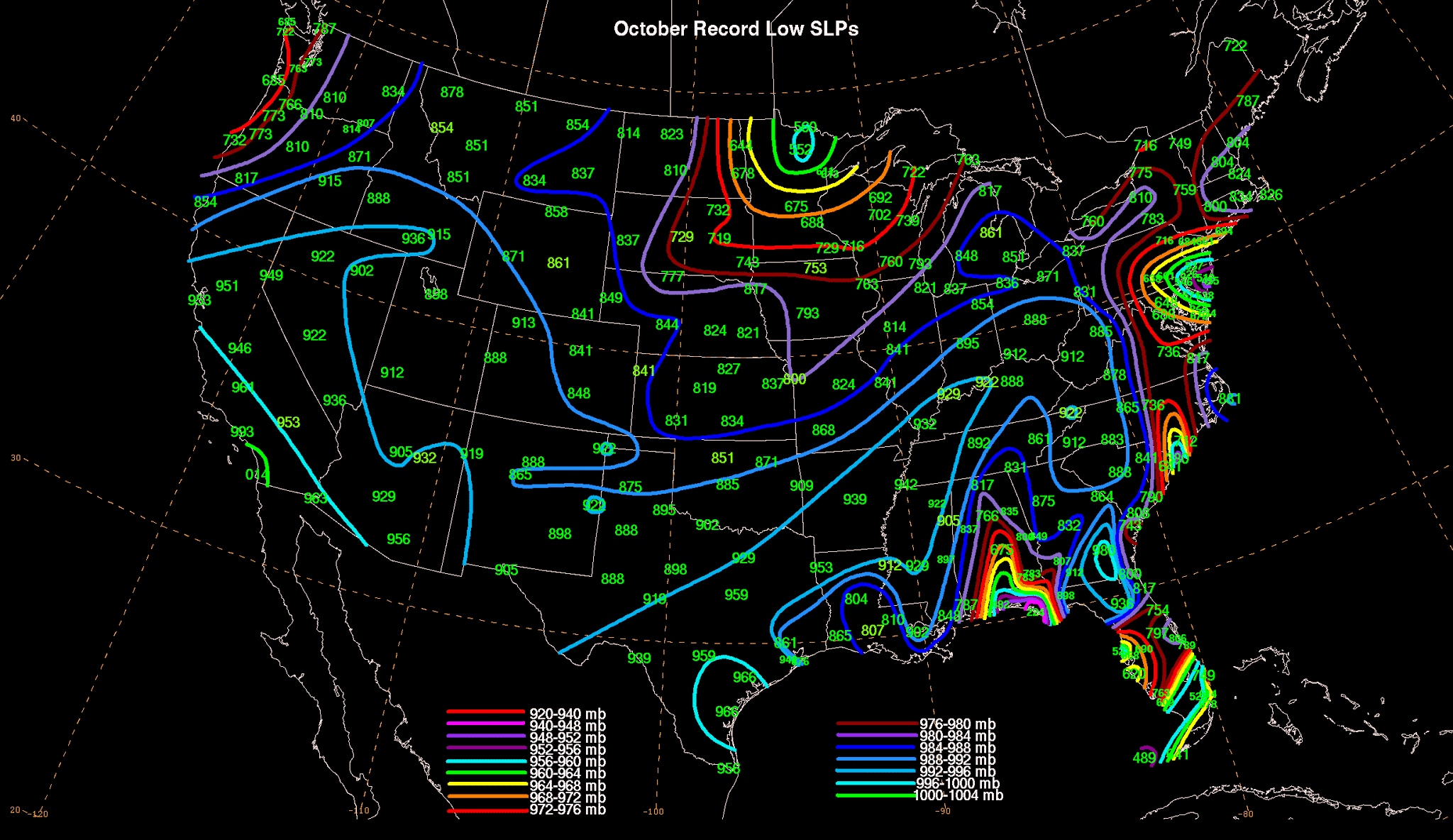
Record low air pressure records for the month of October. | Source: NOAA/WPC
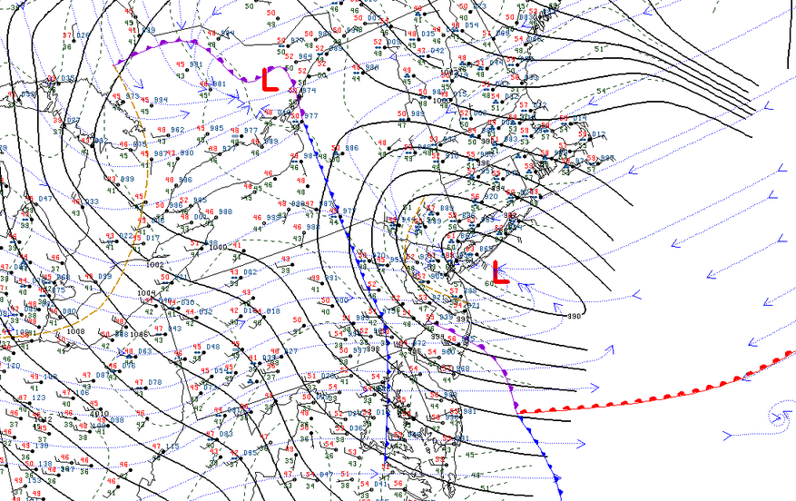
This storm’s minimum pressure dropped in a hurry. The low
had a minimum central pressure of 998 mb as it passed over the Delmarva
Peninsula at 2:00 PM on Wednesday. Its pressure had dropped to 988 mb six hours
later as it approached New York City. Most weather models have the system’s
minimum pressure falling below 975 mb as the storm moves into interior New
England during the day on Thursday. A pressure that low would set some all-time
minimum pressure records at some weather stations in New England; air pressure records for the month of October are shown above.
How does a storm strengthen that quickly, anyway? Divergence.

Divergence describes winds fanning out in the upper levels of the atmosphere. Winds tend to spread apart as they leave the base of a trough or as they enter and exit stronger parts of the jet stream, known as jet streaks. Air has to rush upward to fill the void left behind by the diverging winds, leaving less air—a center of low pressure—at the surface.

An analysis of the jet stream at 8:00 PM on Wednesday. | Image: Tropical Tidbits, with my annotations

We have three sources of lift working on tonight’s nor’easter as it revs up off the coast of New Jersey. The above model image shows an analysis of the jet stream at 8:00 PM on Wednesday.

A strong trough, combined with two different jet streaks, are all working together to lift massive amounts of air from the surface. If multiple sources of divergence align with each other like we’re seeing right now, air has to rush upward from the surface really fast to compensate for the void left by the winds spreading out. This leads to the rapid strengthening of a low-pressure system at the surface. The storm will begin to weaken once it starts to lose that lift from above. In this case, the storm will slowly lose steam as it meanders toward Atlantic Canada on Friday.


You can follow me on Twitter or send me an email.

Please consider subscribing to my Patreon. Your support helps me write engaging, hype-free weather coverage—no fretting over ad revenue, no chasing viral clicks. Just the weather.
 

Author

Dennis Mersereau

I have 15+ of experience providing hype-free weather information for folks across the United States and around the world. In addition to DAMWeather, I also contribute to The Weather Network as a digital writer and weather specialist.

Follow Me
Other Articles
Previous

Two Feet Of Snow Is Possible In North Dakota As The Season’s First Cold Air Arrives

Next

Tropical Storm Nestor Set To Hit Florida Saturday With Heavy Rain, Gusty Winds


Local ◈ UTC
Facebook | Bluesky
Instagram | Threads | Email
DAMWeather is now ad-free! Everyone benefits from engaging, hype-free weather coverage. Please consider supporting my efforts through Patreon:


Order The Skies Above today!

Bookshop.org || Barnes & Noble
Mountaineers Books || Amazon

My latest book, The Skies Above, is now available!

Did you know a puffy cloud can weigh millions of pounds? Or that every rainbow you see is unique to you?

Our atmosphere is full of spectacular sights that are always within your reach. Glistening layers of fog, gorgeous sunsets, and brilliant meteors flashing through the sky can light up even the calmest day.

The Skies Above, published by Mountaineers Books, is a celebration of what we overlook when we look up. I was thrilled to work with the editors and illustrators at Indelible Editions to share with you the quotidian beauty of our sky.

Order your copy now and learn about the wonders we take for granted every day.

I teamed up with the editors of Outdoor Life magazine to write The Extreme Weather Survival Manual, your guide to surviving and thriving in almost any weather condition. Whether you're an avid outdoorsperson or you enjoy watching the radar from the comfort of your home, you're sure to find helpful tips, advice, and new bits of knowledge in this fascinating book.

You can buy my book today through Amazon.
  • 2026 (34)
  • 2025 (49)
  • 2024 (59)
  • 2023 (43)
  • 2022 (57)
  • 2021 (71)
  • 2020 (83)
  • 2019 (88)
  • 2018 (92)
  • 2017 (1)
  • 2016 (4)
  • 2015 (10)

Copyright 2026 — DAMWeather. All rights reserved. Blogsy WordPress Theme