A Drenching Storm Could Bring Severe Storms, Flash Flooding To The Southeast Thursday


An unusually juicy storm for early February will drench the southeastern United States on Thursday, carrying a moderate risk for flash flooding and an enhanced risk for severe thunderstorms. The sprawling system is so large that it’ll produce significant snows in northern New England at the same time it’s bringing heavy rain to the southeast.
Flash Flooding
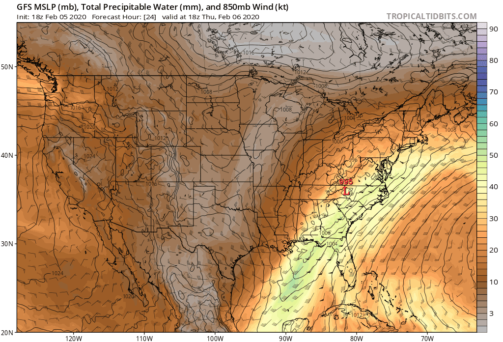 |
| Precipitable water on Thursday afternoon, per the GFS model (Tropical Tidbits) |
Widespread flash flooding is a distinct possibility along and east of the Appalachian Mountains on Thursday as a surge of moisture moves north from the tropics.
The above model image shows precipitable water (PWAT) on Thursday afternoon. PWAT is a measure of how much moisture is available in the atmosphere. If the PWAT value for Podunk is 1.00″, it means that 1.00″ of rain would fall if you were to wring out all the moisture in the atmosphere over that particular spot.
Higher PWAT values indicate a greater potential for heavy, flooding rains. Models indicate a potential PWAT of 1.50″ (roughly 40 mm) or more across the interior southeast on Thursday, which is extremely unusual this far north at the beginning of February.
The heaviest rain and highest totals are likely in thunderstorms and along the eastern side of the Appalachians where orographic lift enhances the rainfall rates.
A moderate risk for flash flooding exists along and east of the Appalachians in Georgia, South Carolina, and North Carolina, according to the Weather Prediction Center’s update on Wednesday night. It won’t take much heavy rain to send waterways over their banks and overwhelm man-made drainage systems in populated areas.
The flooding threat here is similar to what we’d see from the remnants of a landfalling tropical cyclone. Thursday’s weather is more common of the warm season than February 6—but it’s also felt more like April for much of the winter, so why not?

Some areas could see more than 5.00″ of rain as a result of the heavy and persistent rain. The Weather Prediction Center‘s latest rainfall forecast paints a widespread area of 4″+ of rain across the Southeast, with even higher totals possible along the eastern side of the Appalachians and where thunderstorms enhance rainfall rates.
Severe Thunderstorms

It’s not just flooding that we have to worry about. The influx of warm, moist air, combined with extremely strong winds not far above the surface, will allow lines of strong or severe thunderstorms to develop and move across the southeast on Thursday.
Thunderstorms that fire up won’t have to work hard to produce damaging winds, isolated tornadoes, and occasional instances of large hail.
An enhanced risk for severe weather is in effect on Thursday across much of the southeast from Florida’s Big Bend through central North Carolina, including the cities of Tallahassee, Columbia, and Charlotte. Slight risk and marginal risk areas radiate out from there, covering just about everyone between Mobile and the Virginia suburbs of D.C.
It’s likely that a portion of the severe weather will occur after dark, ratcheting up the threat as people tune out for the evening and go to sleep.
The best way to prepare for this kind of severe weather and flooding threat is to make sure the wireless emergency alerts are activated on your smartphone. I know it’s repetitive to bring it up in every one of these posts, but lots of folks shut off the alerts after one ill-timed interruption. The push alerts are proven lifesavers, and it’s possible for tornado warnings to catch you off-guard at home (it’s even happened to me!) and it’s even more common to unknowingly drive into an area experiencing flash flooding.
Snowstorm


The storm left a decent blanket of snow across the southern Plains in its infancy on Tuesday night. This was the first significant winter storm to hit the area in a while. Oklahoma City measured its first inch of snow since January 19 of last year, and this was the first measurable snow in Midland, Texas, since December 8, 2016.
Please consider subscribing to my Patreon. Your support helps me write engaging, hype-free weather coverage—no fretting over ad revenue, no chasing viral clicks. Just the weather.