A Meteorologist’s Nightmare: A Strong Tornado Struck Downtown Nashville After Midnight

Nashville lived through a nightmare early Tuesday morning as a strong tornado struck the city’s core in the middle of the night. The tornado—or tornadoes, if there were several along a path—touched down west of Nashville after midnight and likely continued well to the city’s east, killing at least nine people and damaging hundreds of homes and businesses. The tornado was strong enough to loft debris thousands of feet into the air just as it began moving over the heavily populated downtown core.
The long-lived supercell began in west-central Tennessee and moved toward the Nashville region around midnight. The Storm Prediction Center issued a tornado watch for central Tennessee at 11:20 PM CST as they watched the supercell move toward the area. (Yes, they really do issue watches for single thunderstorms, and for good reason!)
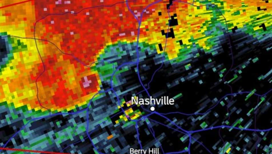
The National Weather Service issued a severe thunderstorm warning for Nashville and surrounding areas at 12:11 AM. The supercell’s well-defined hook echo tightened up considerably as it approached Nashville proper, prompting a tornado warning at 12:35 AM. Debris began showing up on radar within a few minutes, and a debris ball was clearly visible on radar a few miles northwest of Nashville by 12:38 AM (shown in the screenshot at the top of this post). The fast-moving tornado struck the north side of downtown Nashville at about 12:42 AM, continuing east of the city over the next hour.
An employee of NWS Nashville caught video of the rain-wrapped tornado as it moved through the city’s core. It’s hard to see the tornado as it’s obscured by rain and the dark of night, but power flashes caused by transformers failing in the strong winds make the path easily traceable as it races through town.
The supercell that spawned the tornado (or tornadoes) is an example of how it only takes a brief moment of the right ingredients coming together to create an exceptionally dangerous situation. The SPC’s discussion of the tornado watch mentioned how the storm “may maintain its organization in a marginally favorable low-level air mass for a few hours before weakening.” It sure did. The supercell found just enough instability and low-level wind shear along a surface boundary north of Nashville to spin up a strong tornado.
Meteorologists will survey the damage on Tuesday and issue a preliminary rating based on the damage they find.
The very situation that played out in central Tennessee last night is one of the scenarios that keeps meteorologists and emergency managers awake at night. A tornado approaching a city center is terrifying any day, but a strong, fast-moving tornado at 12:30 in the middle of the night is near the top of the list when it comes to dangerous situations.
Severe weather is possible across parts of the southern U.S. over the next couple of days. As we head through this period of active weather—and start climbing toward the peak of springtime severe weather—it’s important that you have multiple ways to receive severe weather warnings. You don’t want to get caught off guard by a storm anytime, but especially at night when you’re tuned-out or asleep.
Make sure your cell phone is set to receive Wireless Emergency Alerts for tornado warnings. Spring a few bucks for a programmable NOAA Weather Radio if you can. It may seem redundant or outdated given all the technology we have now, but phones and weather apps don’t always work. It’s good to have a backup.
[Screenshot: Radarscope]
You can follow me on Twitter or send me an email.
Please consider subscribing to my Patreon. Your support helps me write engaging, hype-free weather coverage—no fretting over ad revenue, no chasing viral clicks. Just the weather.
Please consider subscribing to my Patreon. Your support helps me write engaging, hype-free weather coverage—no fretting over ad revenue, no chasing viral clicks. Just the weather.