A Festive Mid-May Cold Snap Will Make Things Interesting For A Change


It’s almost the middle of May. Crops are germinating. Flowers are in bloom. Leaves are fully leafed. So of course we’re talking about the potential for accumulating snow! Welcome to a topsy-turvy weather pattern that’s sure to bring a festive verve to the monotony of staying at home. A burst of heat will build across the western United States while a late-season cold snap in the east brings frosty temperatures to many and snow to some.
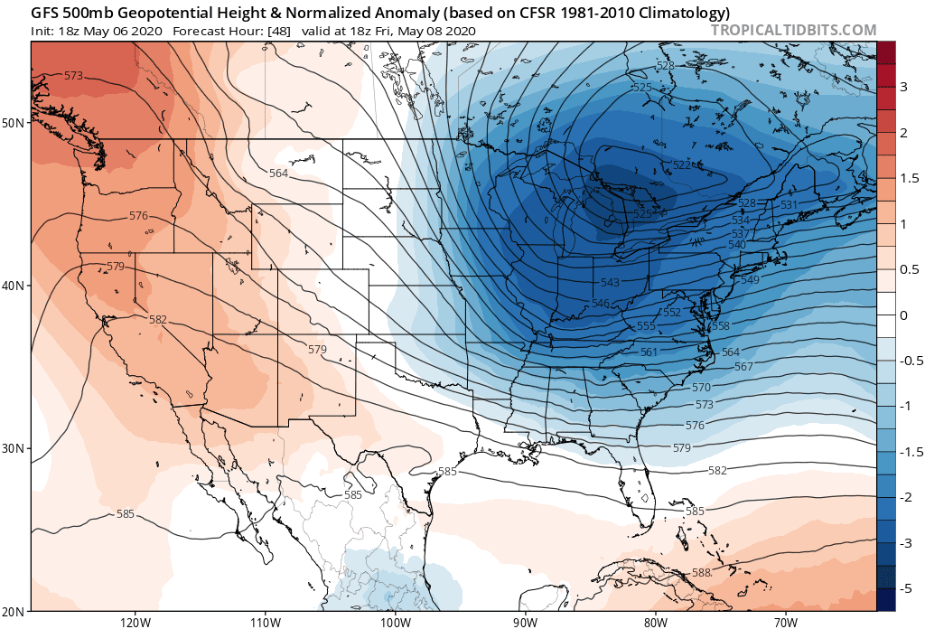 |
| Source: Tropical Tidbits |
A wavy jet stream will allow a sharply divided weather pattern to develop across the United States by the end of the week. A steep ridge will build west of the Rocky Mountains while a hearty trough digs south through the Great Lakes. The above-average temperatures out west and below-average temperatures back east will threaten to break daily temperature records on both ends of the spectrum.

The National Weather Service’s high temperature forecast for Saturday is a stark example of what a pronounced ridge-trough pattern looks like. The west will register a solid “balmy” with 80s reaching Seattle and upper 90s as far north as California’s Central Valley. Some cities out west will see record high temperatures over the next few days. Outside the heart of the deserts, it usually doesn’t get this warm for a while yet.

Back east, Saturday would be considered a beautiful day if it wasn’t May 9th. Temperatures will dip well below normal for this time of year; folks on the northern Gulf Coast could see their breath on Saturday morning. Such a late freeze will threaten crops and gardens if they’re not protected.
We’ll see lots of comfort-related complaining about the sudden resurgence of cooler weather this weekend, but it’s not all bad. This kind of forecast is a dream come true for cold weather folks like me. It won’t be long until we’re in a months-long slog of hot and muggy weather with occasional severe storms. Everyone will complain about that soon enough. Enjoy the chill while we’ve got it.
Where there’s cold air and precipitation, there’s a chance for…

A low-pressure system will swoop across the Mid-Atlantic and Northeast on Friday evening into Saturday morning, bringing the potential for snow on the northern edge of the system. Models are a bit wishy-washy on who might see what—it’s May, give them a break—but the National Weather Service does paint some accumulating snow across interior parts of the Northeast on Friday.
The map above doesn’t cover the entire period when snow is possible. The map stops at Friday evening, while the bulk of the potential snow could occur overnight into Saturday. The data is also a little off because NWS Buffalo hadn’t issued their snowfall forecast when I created the map, hence the conspicuous emptiness in western New York. But it gives you a good idea at where there’s a chance for wintry weather to end the week.
There’s an outside chance that snowfall totals will wind up edging a bit higher and nudge closer to big cities like Boston. Any snow that does fall won’t stick around very long given borderline temperatures and a sun angle that’s equivalent to what we see in August.

The Climate Prediction Center’s latest outlook shows that it’s likely we’ll see below-normal temperatures continue across much of the eastern United States through next week, although not to such an extent as we’ll see this weekend. Things should return to a more May-like state by next weekend.
You can follow me on Twitter or send me an email.
Please consider subscribing to my Patreon. Your support helps me write engaging, hype-free weather coverage—no fretting over ad revenue, no chasing viral clicks. Just the weather.