Here’s Your Friday Night Update On Hurricane Isaias As It Approaches Florida


Hurricane warnings are up for portions of southeastern Florida as Hurricane Isaias (pronounced ees-ah-EE-ahs) traverses The Bahamas on Friday night. The hurricane’s outer bands will begin to affect the Miami area during on Saturday, with conditions rapidly deteriorating Saturday night and through the day on Sunday. Most of the U.S. East Coast and the Canadian Maritimes are at risk of seeing strong winds and heavy rain from this storm through early next week.
Hurricane Isaias
Isaias is a resilient storm. After several days of struggling to develop in the eastern Caribbean Sea, the system got its act together in a hurry over Hispaniola. While the island’s rough terrain typically brings tropical cyclones to a hasty end, the center of what became Isaias seemed unaffected by the terrain. The system rapidly strengthened into a hurricane on Thursday night and it’s maintained intensity over the last 24 hours.
It looks interesting on satellite imagery. Radar shows an eyewall developing, but dry air on the western side of the storm won’t let the eyewall fill in, precluding an eye from clearing out in the clouds. There’s a large mass of convection on the eastern side of the storm, while the western side is struggling against that dry air and a bit of wind shear.
Forecast Track

The National Hurricane Center‘s forecast at 11:00 PM EDT on July 31, 2020, shows the hurricane dragging along Florida as a hurricane before skirting up the entire U.S. East Coast and into the Canadian Maritimes as a strong tropical storm.
Accordingly, a whole slate of watches and warnings are up for the Florida Peninsula, including a hurricane warning for coastal counties from Boca Raton, Florida, northward to the Volusia/Brevard County line (just north of Cape Canaveral). Expect these alerts to extend up the coast over the next few days.
If the storm remains on its current projected path, the storm will affect the entire coast from Miami to Halifax. The greatest threat right now appears to exist in both Florida and North Carolina, both of which could feel the strongest winds, rain, and storm surge with the closest approach of the system’s core.
Forecasters expect Isaias to maintain strength and gradually weaken as it picks up speed and begins to curve up the coast. The environment around the hurricane isn’t too friendly for strengthening, but it’s not out of the question once the core of the storm moves over the Gulf Stream. Remember, storms can unexpectedly intensify, which is a dangerous prospect when they’re this close to land.
Wind & Storm Surge
Hurricane force winds appear most likely in southeastern Florida, which could see the center make about as close of an approach as possible without actually making landfall. Tropical storm force winds are possible over a wider area, including counties that are dozens of miles inland.
The hurricane’s projected path scrapes the eyewall over many dozens of miles of land; we could see entire counties go through a period of damaging winds. Widespread power outages are likely.
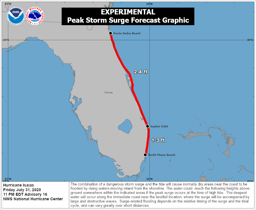
The latest NHC forecast shows a potential storm surge of 2-4 feet above normal tide levels across much of eastern Florida. Their new map—which is quite useful compared to some of their old storm surge graphics—is shown above.
Rain

As usual, the threat for freshwater flooding from heavy rain is the greatest threat anyone in the path of the storm will face. The latest seven-day rainfall forecast from the Weather Prediction Center is shown above. Isaias could produce several quick inches of rain along its path, potentially leading to flash flooding. Some areas could wind up with more rain than predicted above. A track closer to land would bring higher rainfall totals for more people than a track that brings the core of the system farther away from land.
Most of the deaths in a landfalling tropical cyclone occur as a result of flooding from heavy rain. Never cross a water-covered roadway. It’s impossible to judge how deep the water is until it’s too late, and it takes a surprisingly small amount of moving water to lift up a vehicle and carry it downstream.
Tornadoes
There’s enough spin in the atmosphere that tornadoes are always a concern when a tropical cyclone makes landfall (or brushes land). The greatest threat for tornadoes usually exists in the right-front quadrant of the storm relative to its forward motion. Since that right-front quadrant is likely going to stay offshore, the tornado threat is a little lower. That said, some of the storm’s outer bands could produce a quick tornado or two. Tropical tornadoes are fast and they can occur with little or no lead time. Always stay alert and make sure you can get to a safe spot in a hurry if needed.
[Satellite Image: NOAA]
You can follow me on Twitter or send me an email.
Please consider subscribing to my Patreon. Your support helps me write engaging, hype-free weather coverage—no fretting over ad revenue, no chasing viral clicks. Just the weather.