Skip to content
DAMWeather DAMWeather DAMWeather

The weather can get scary. Reporting on it doesn't have to be.

DAMWeather DAMWeather DAMWeather

The weather can get scary. Reporting on it doesn't have to be.

  • About Me
  • All Bylines
    • Books, Bylines, and Press
    • The Skies Above (Book)
    • Extreme Weather (Book)
    • The Weather Network
    • The Vane
    • Forbes
    • Capital Weather Gang
    • Mental Floss
  • Maps
    • Hurricane Maps
    • Hurricane Names
    • Monthly Tornadoes
    • Tornado Tracks
    • F5/EF-5 Tornadoes
    • SPC High Risk Days
  • GIS Resources
  • Contact Me
    • Bluesky
    • Facebook
    • Instagram
  • wxdam.com
  • About Me
  • All Bylines
    • Books, Bylines, and Press
    • The Skies Above (Book)
    • Extreme Weather (Book)
    • The Weather Network
    • The Vane
    • Forbes
    • Capital Weather Gang
    • Mental Floss
  • Maps
    • Hurricane Maps
    • Hurricane Names
    • Monthly Tornadoes
    • Tornado Tracks
    • F5/EF-5 Tornadoes
    • SPC High Risk Days
  • GIS Resources
  • Contact Me
    • Bluesky
    • Facebook
    • Instagram
  • wxdam.com
Close

Search

‘Unsurvivable’ Storm Surge Likely As Intense Hurricane Laura Hits Louisiana Tonight

By Dennis Mersereau
August 26, 2020 7 Min Read

Hurricane Laura rapidly strengthened into a category four storm today with maximum sustained winds of 145 MPH. The storm will likely maintain this intensity as it makes landfall near the Texas/Louisiana state line late tonight. The hurricane will produce destructive winds and a catastrophic and “unsurvivable” storm surge across the low-lying communities in the path of the hurricane, and its flooding rains and damaging winds will extend far inland after it makes landfall.
As feared, the hurricane rapidly intensified overnight Tuesday into Wednesday as it took full advantage of a favorable environment and the steamy hot temperatures of the Gulf of Mexico. The ridge of high pressure allowing the storm to strengthen will start to weaken this evening, allowing the storm to curve into the Gulf Coast and head north toward Arkansas on Thursday. 
It’s likely the hurricane is at or near its peak intensity right now as it’ll encounter some wind shear near landfall. This is a healthy hurricane with a solid structure, though, so the damage is fated at this point and there’s little hope of significant weakening before landfall.

Laura is a large storm. The hurricane’s wind field stretches more than 300 miles across right now, which means tropical storm force winds could reach as far west as Houston and as far east as Baton Rouge. A system of this size and intensity will produce widespread wind damage and push an immense storm surge into the coast where it makes landfall.
Employees evacuated the National Weather Service office in Lake Charles, Louisiana, today, transferring their duties to other NWS offices around the country. NWS offices regularly plan and practice handing over responsibilities to other offices for just this kind of a situation. Folks who live in this region won’t experience any disruption in watches or warnings issued by the agency. The fact that they had to shut down and leave should speak volumes to the threat posed to the region by this storm.
The hurricane will make landfall between Port Arthur and Lake Charles around midnight local tonight, steadily pushing inland over the next day or so. The worst of the wind and rain will reach northern Louisiana by Thursday morning and move into Arkansas during the day. The remnants of the storm will turn east and head toward the Mid-Atlantic this weekend. There’s a chance that the storm could begin to redevelop in the Atlantic Ocean as it heads toward Newfoundland early next week.
This is an extremely tough situation for folks in harm’s way. Lots of people in this region don’t have the money or the means to evacuate during good times, let alone during an economic downturn in the middle of a raging pandemic. Given the extreme conditions expected during this storm’s landfall, the news from the aftermath could be quite grim—more than we’re used to by modern standards in this country—if lots of people didn’t or couldn’t evacuate.

Wind

The intense winds in the eyewall of a category four hurricane will damage most structures. Mobile homes will be destroyed. The gabled roofs on many homes will experience total or near-total failure, which could compromise the rest of the structure. Extensive and widespread tree damage will make travel nearly impossible even on roads that aren’t flooded by the catastrophic surge. The power grid will take weeks to repair in the hardest-hit areas. 
Strong winds won’t be confined to coastal communities. Hurricane warnings are in effect deep into eastern Texas and western Louisiana, with tropical storm warnings stretching up into southern Arkansas. These areas could see widespread tree damage and long-lasting power outages. As I mentioned last night, there are probably quite a few folks inland who will be surprised by the power outages.

Storm Surge

Source: National Hurricane Center

Laura is moving into a part of the Gulf Coast that’s exceptionally vulnerable to a catastrophic storm surge. The coast here is miles and miles of swampland. There’s not much to stop the full force of a devastating storm surge from pushing dozens of miles inland as this hurricane makes landfall.
This afternoon’s update had about the strongest language the NHC can use:

Unsurvivable storm surge with large and destructive waves will cause catastrophic damage from Sea Rim State Park, Texas, to Intracoastal City, Louisiana, including Calcasieu and Sabine Lakes. This surge could penetrate up to 40 miles inland from the immediate coastline, and flood waters will not fully recede for several days after the storm.

The latest forecast from the National Hurricane Center shows a potential storm surge of 15-20 feet above ground level that would push water dozens of miles into the Louisiana swamps. Their latest inundation forecast shows how far the water could push inland away from the coastline. Their map scale stops at “greater than 9 feet;” some of these areas could see double that depth.

Here’s a zoomed-in look:

The U.S.G.S. set up a special network of sensors along the coast to measure Hurricane Laura’s storm surge in real time. As of this post, the surge is already starting to rise in Cameron Parish and the storm is still a long way from landfall.

One of the hardest-hit communities could be Lake Charles, Louisiana, which sits just a few feet above sea level at the mouth of the Calcasieu River. Meteorologists expect a 15-20 foot storm surge to push into Lake Calcasieu, and the latest NWS forecast calls for water to crest at 15.6 feet at the gauge near downtown Lake Charles.

This would be the largest flood on record in Lake Charles, surpassing the previous record flood of 13.0 feet on October 1, 1913, during which record was a 13.0-foot flood measured on October 1, 1913; when water reaches that record height, “over half the city of Lake Charles is flooded.”

Flooding Rains

Widespread flash flooding will result from Laura’s heavy rains as it pushes inland over the next couple of days. Some communities near the center of the storm’s path could see up to a foot of rain with the heaviest and most persistent rainbands. The swath of high rainfall totals will stretch into Arkansas as the storm slows down and turns east through the end of the week.
The greatest threat to the safety of folks who live inland will be flash flooding from heavy rain. It won’t take long for these tropical rains to overwhelm waterways and sewerage systems. It’s especially dangerous that much of the rain will occur at night, making it even harder to see water-covered roadways.

Tornadoes

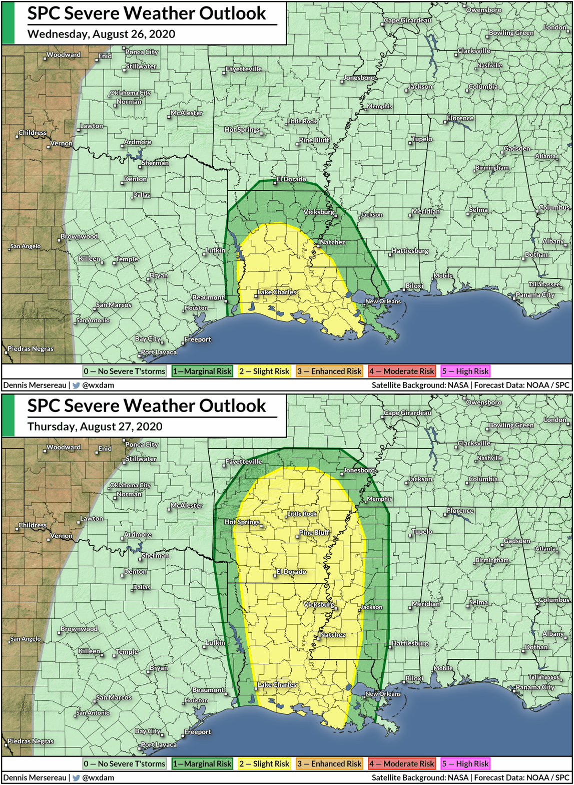
A risk for tornadoes exists on the eastern side of the storm as it pushes inland. Tornado warnings are already popping up along the storm’s outer bands as thunderstorms tap into the low-level rotation in the atmosphere. Tropical tornadoes are no joke—they can happen quickly and they can cause significant damage. 
The risk for tornadoes will overspread Louisiana and into Arkansas and Mississippi through Thursday.

Beware The Comparisons

Source: NOAA Historical Hurricane Tracks

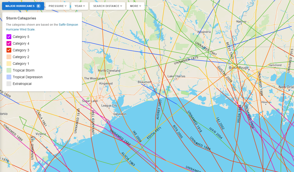
If the hurricane maintains its intensity through the night, Laura would be the strongest storm to hit this stretch of coastline in records dating back to 1851. We’re in uncharted territory as far as the type of damage this kind of wind and storm surge could do to this region.
Understandably, this hurricane is drawing comparisons with Harvey back in 2017. That was a devastating storm for southeastern Texas. But those comparisons are tainted by our bias toward recent storms and it muddles the true threats posed by the storm approaching land today.
Harvey came ashore near Corpus Christi as a category four and entered an environment with no upper-level winds to steer it along, forcing the storm to sit and spin over southeast Texas for days while it produced foot after foot of rain.
Laura, on the other hand, will keep moving at a steady pace once it’s ashore. This storm will produce widespread inland flooding from heavy rains, but the greatest threat to life and property will be the storm’s destructive winds and catastrophic storm surge.
If you’re looking for a storm that might give some clue as to what will unfold tonight, the last major hurricane to make landfall near the Texas/Louisiana border was Hurricane Rita in 2005. Rita came ashore near Port Arthur, Texas, as a category three with 115 MPH winds.
That hurricane produced a storm surge as deep as 15 feet in southwestern Louisiana, devastating many communities in the region. The NHC’s post-storm report noted that there was so much damage that analyzing the true extent of the storm surge was “daunting.”
Each storm is different and even comparisons to Rita are tenuous. This region has never recorded such a strong hurricane at landfall, so comparing it to past storms is tough to begin with. But specifically bringing up Harvey in this situation is unnecessarily upsetting to folks who survived that storm three years ago, especially when the Houston area won’t feel the worst of this storm tonight. 
[Satellite: NOAA]

You can follow me on Twitter or send me an email.

Please consider subscribing to my Patreon. Your support helps me write engaging, hype-free weather coverage—no fretting over ad revenue, no chasing viral clicks. Just the weather.
 

Author

Dennis Mersereau

I have 15+ of experience providing hype-free weather information for folks across the United States and around the world. In addition to DAMWeather, I also contribute to The Weather Network as a digital writer and weather specialist.

Follow Me
Other Articles
Previous

Hurricane Laura Could Reach Major Hurricane Strength By Landfall On Wednesday Night

Next

As Laura Pushes Inland, It’s Clear The Hurricane’s Extreme Warnings Were Justifiable


Local ◈ UTC
Facebook | Bluesky
Instagram | Threads | Email
DAMWeather is now ad-free! Everyone benefits from engaging, hype-free weather coverage. Please consider supporting my efforts through Patreon:


Order The Skies Above today!

Bookshop.org || Barnes & Noble
Mountaineers Books || Amazon

My latest book, The Skies Above, is now available!

Did you know a puffy cloud can weigh millions of pounds? Or that every rainbow you see is unique to you?

Our atmosphere is full of spectacular sights that are always within your reach. Glistening layers of fog, gorgeous sunsets, and brilliant meteors flashing through the sky can light up even the calmest day.

The Skies Above, published by Mountaineers Books, is a celebration of what we overlook when we look up. I was thrilled to work with the editors and illustrators at Indelible Editions to share with you the quotidian beauty of our sky.

Order your copy now and learn about the wonders we take for granted every day.

I teamed up with the editors of Outdoor Life magazine to write The Extreme Weather Survival Manual, your guide to surviving and thriving in almost any weather condition. Whether you're an avid outdoorsperson or you enjoy watching the radar from the comfort of your home, you're sure to find helpful tips, advice, and new bits of knowledge in this fascinating book.

You can buy my book today through Amazon.
  • 2026 (34)
  • 2025 (49)
  • 2024 (59)
  • 2023 (43)
  • 2022 (57)
  • 2021 (71)
  • 2020 (83)
  • 2019 (88)
  • 2018 (92)
  • 2017 (1)
  • 2016 (4)
  • 2015 (10)

Copyright 2026 — DAMWeather. All rights reserved. Blogsy WordPress Theme