California Will Roast This Weekend While Fall’s First Freeze Slides Down The Rockies

The big weather story this Labor Day weekend, for the first time in years!, doesn’t involve hurricanes or severe weather. This weekend will see wild temperature extremes across the western half of the United States, roasting California in blistering heat while the Rockies and Plains have to deal with a powerful cold front that generates a 60°F temperature swing between Sunday afternoon’s high and Tuesday morning’s low.
California Heat
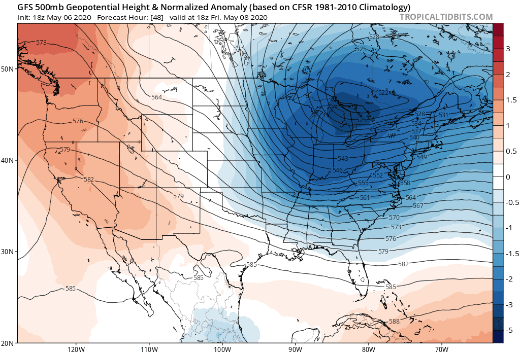 |
| A model image of the intense upper-level ridge over the West Coast this weekend. | Source: Tropical Tidbits |
A record-smashing heat wave in California will make a bad summer even worse. Temperatures on Sunday and Monday could threaten to break all-time high temperature records in some communities.
The heat is the result of a really strong ridge of high pressure building over the West Coast, pictured in the model image above. Air sinks beneath an upper-level ridge, drying and warming as it descends toward the surface. Stronger ridges can foster stronger heat waves.
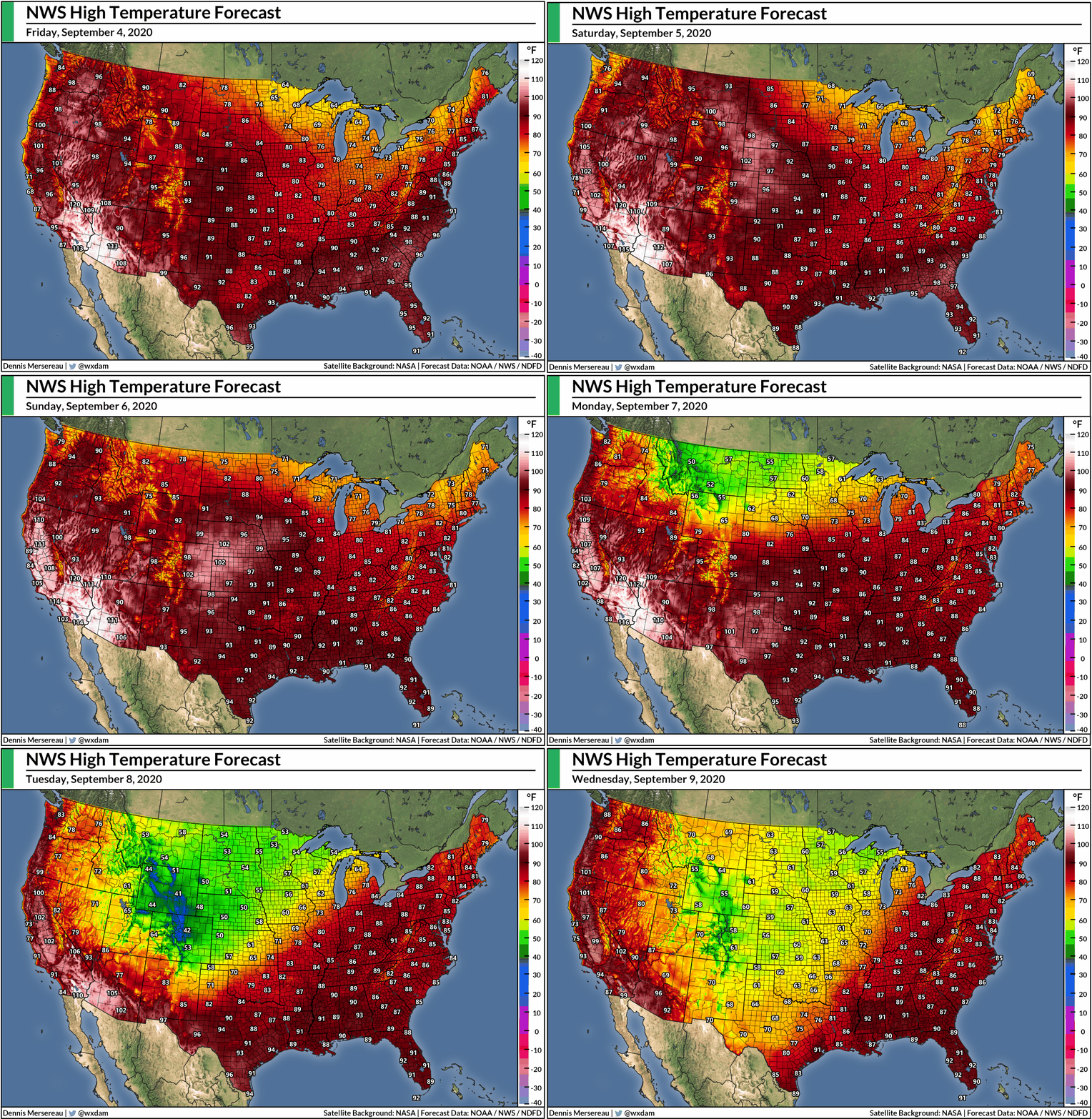
Here’s the National Weather Service’s high temperature forecast for Sunday…

…and the same for Monday:

These temperatures will push daily, monthly, and even all-time record high temperatures in communities across California. A high of 111°F on Sunday would be the third-hottest temperature ever recorded in downtown Los Angeles. A high of 111°F on Sunday in Sacramento would be the city’s hottest day since July 2006 and also one of the top-ten hottest days on record there. And so on down the list for communities across southern California and the Central Valley.
It’ll be hot enough that folks won’t have to spend too much time in the heat to incur heat-related illnesses. Even otherwise-healthy folks could succumb to the heat if they’re exercising or working too hard in the heat without frequent breaks and access to air conditioning. This kind of heat will affect elderly folks and those who are battling illnesses (like COVID-19!) especially hard.
It’s not just the heat itself. The intense heat and low humidity will create favorable fire weather conditions for the duration of the event. California’s already been hit hard by wildfires this year. Three of the ten-largest wildfires on record started last month in California and they’re still burning today. Conditions this weekend will allow fires to spark and spread with little effort, putting pressure on already-strained resources across the state.


Heatwave Breaks In A Cold Snap On The Plains
An upper-level trough riding around the outer edge of the western ridge will dive south along the Rockies by the end of the weekend. The trough will drag south with it a tremendous surge of frigid air from Canada. This will be the first big blast of fall for the center of the country.
This event isn’t quite a blue norther—a cold front that rides along the eastern edge of the Rockies and brings dramatic temperature changes—because those events are characterized by temperatures plummeting dozens of degrees in just an hour or two. This cold front will hit and steadily erode the temperature for hours and hours until you bottom out around freezing.
Here’s the NWS’s high temperature forecast for Sunday:
And then the low temperature on Tuesday morning:
Big difference!
The Denver area will see a highs in the upper 90s on Sunday and another high in the upper 80s during the day on Monday. The cold front will enter Colorado on Monday night, allowing temperatures to steadily drop to freezing by Tuesday morning. It’s going to be one of those days where most people in this region will see their high temperature at 12:00 AM one day.
Rain and snow are likely behind the cold front. It’s still too early to talk about accumulation potential, but the snow could get heavy in some areas—especially at higher elevations. Snow this early in the season can be dangerous since trees are still in full leaf and the weight of the snow in addition to the weight of the leaves can stress trees and tree limbs to their breaking point. Areas that see several inches of heavy, wet snow accumulation could see widespread tree damage and power outages as a result.
The animation at the top of this post shows high temperatures through next Wednesday. Comfortable temperatures and lower humidity will stretch all the way down into Texas. It’s not here to stay, but next week will be a nice reprieve from a long, awful summer.
You can follow me on Twitter or send me an email.
Please consider subscribing to my Patreon. Your support helps me write engaging, hype-free weather coverage—no fretting over ad revenue, no chasing viral clicks. Just the weather.