Hurricane Delta Will Likely Hit Louisiana On Friday As A Large And Dangerous Storm


Hurricane Delta will make landfall along the Louisiana coast on Friday. The latest forecast from the National Hurricane Center indicates Delta could reach land as a large and dangerous hurricane, bringing the threat for a life-threatening storm surge, destructive winds, and flash flooding from heavy rainfall. Any landfalling hurricane is bad enough, but this is a sensitive stretch of coastline and the area is still reeling from the damage left by Hurricane Laura back in August.
Delta isn’t nearly as strong as it was this time yesterday. The hurricane strengthened into a (tiny!) category four storm with maximum winds of 145 MPH in the far western Caribbean on Tuesday. A combination of wind shear and changes in the storm’s internal structure forced it to weaken before making landfall on the Yucatan Peninsula.
 |
| Source: NOAA |
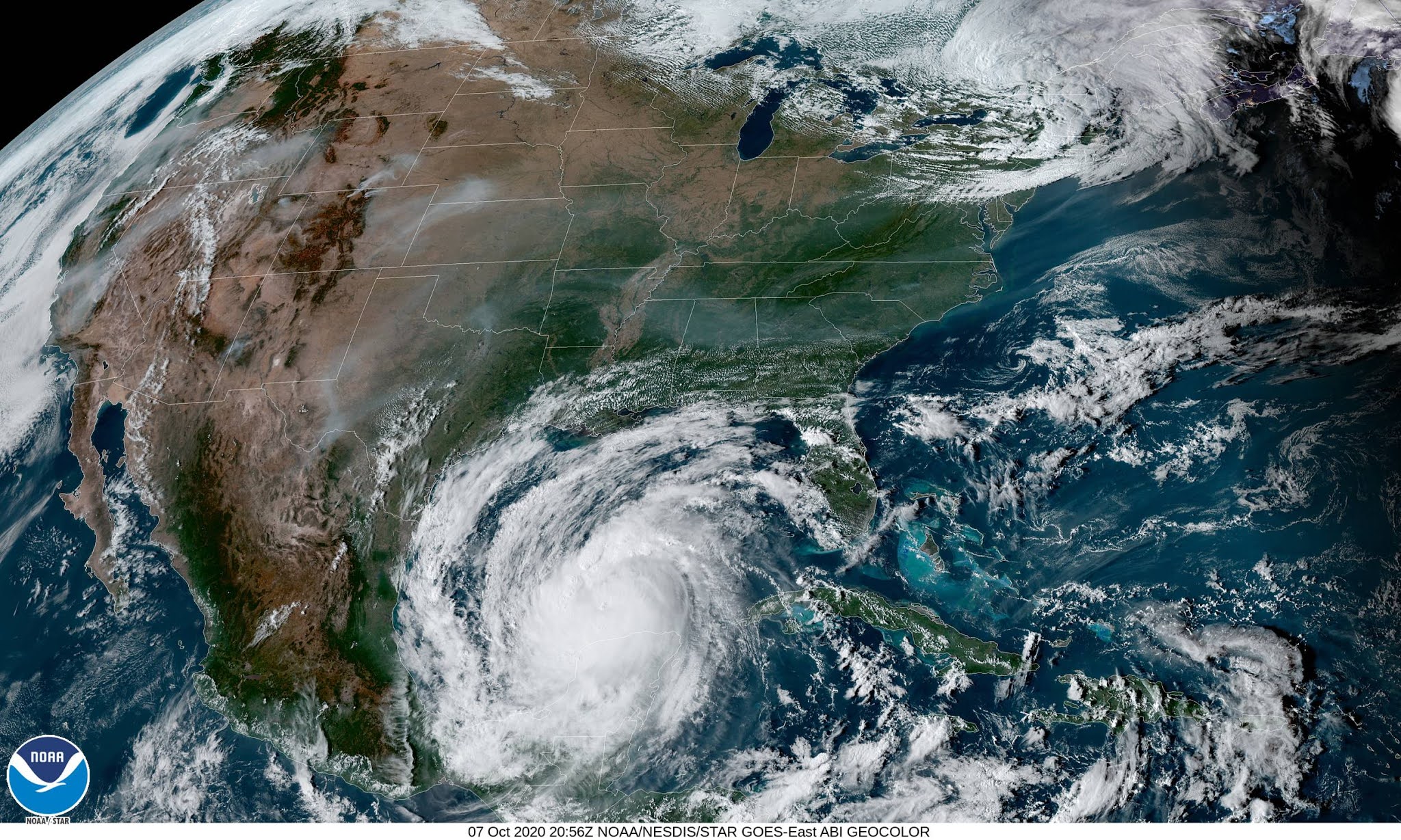
The system spent a couple of hours this morning over the Yucatan before emerging over the southern Gulf of Mexico. Delta has a pretty healthy appearance on satellite imagery this afternoon—the hurricane’s well-build structure will allow the storm to take advantage of favorable conditions around it and begin restrengthening.
The National Hurricane Center’s 4:00 PM CDT advisory placed Hurricane Delta’s maximum sustained winds at 85 MPH, and the forecast calls for the storm to restrengthen into a major hurricane by Thursday afternoon. Unlike the previous four hurricanes that hit the U.S. this year, Delta should start to weaken a bit as it approaches land as a result of increased wind shear and cooler waters.
The system will still be a large and powerful hurricane by the time it makes landfall, so don’t take much solace in the word “weaken” here. A larger storm will mean that the effects of storm surge and damaging winds will affect a larger area as the hurricane makes landfall and pushes inland.
Storm Surge
 |
| Source: NHC |
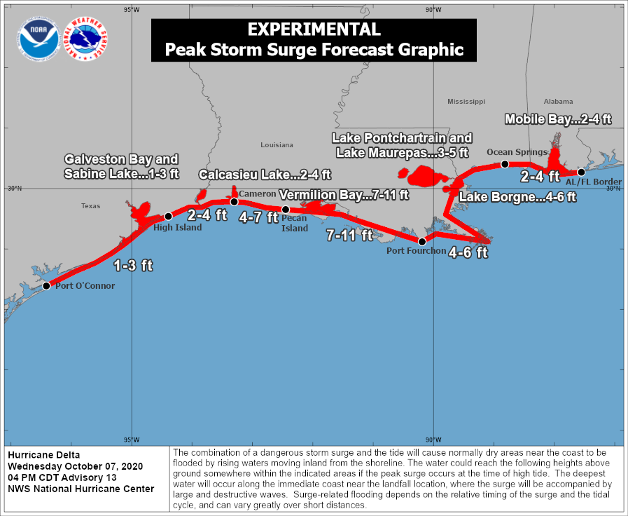
Hurricane Delta’s long-fetch approach into the northern Gulf Coast, combined with the storm’s strong winds, will allow a life-threatening storm surge to build up along the coastline as it makes landfall.
Based on current forecasts, the worst surge will push into Vermillion Bay and the surrounding area. The flat, marshy terrain of Louisiana’s coastline makes the region exceptionally vulnerable to a storm surge. A significant storm surge here could push many miles inland from the coastline.
The greatest push of water will occur in the right-front quadrant of the storm, which will be the eastern side of the eyewall. A slight westward or eastward nudge in the storm’s track will cause the storm surge “bullseye” to follow in kind.
Since Delta’s wind field is growing, a dangerous storm surge won’t be confined to areas right around the point of landfall. Portions of southwestern Louisiana hard-hit by Laura’s storm surge could see another surge deep enough to inundate the first floor of structures along the coast. A storm surge as much as 4 feet above ground level could occur as far east as Mobile Bay.
Winds
The growing size of the storm will expose a large area to damaging winds as Delta makes landfall and pushes inland. It’s likely that hundreds of thousands of households across Louisiana and Mississippi will lose power at some point during the storm. The hardest-hit areas could be out for a week or longer depending on the extent of the damage.
Prepare for power outages even if you’re hundreds of miles inland from the expected point of landfall. Make sure you have enough ready-to-eat food, water, batteries, and USB recharging packs to last at least a couple of days without power.
It’s a good idea to spend Wednesday night and Thursday securing loose items outside—tables, chairs, grills—so they don’t become projectiles in strong winds. Take care of any limbs or trees looming over your property. If you can’t do that, avoid rooms where falling limbs or trees could crash through the roofs or walls. A significant number of injuries and deaths in recent storms were the result of trees crashing into homes.
Flooding

Delta and its remnants will produce widespread heavy rainfall across the southeastern United States through this weekend. The Weather Prediction Center’s latest forecast, pictured above, shows the potential for 5+ inches of rain to follow the track of the system inland. This much rain in a short period of time will lead to flash flooding issues, especially in areas that are normally prone to flooding.
You probably know the deal by now—it takes a surprisingly small amount of water to lift up a vehicle and carry it downstream. It’s impossible to tell how much water covers a roadway until it’s too late. Sometimes floodwaters can completely obscure that the road is washed away. Make sure you’ve got alternate routes to get around if you have to go out during the heavy rain.
You can follow me on Twitter or send me an email.
Please consider subscribing to my Patreon. Your support helps me write engaging, hype-free weather coverage—no fretting over ad revenue, no chasing viral clicks. Just the weather.