Why Tropical Storm Eta Followed Such An Odd, Zig-Zaggy Path Toward Florida


It’s not a surprise that a strange storm formed during a strange year. We’ve been watching Tropical Storm Eta for almost two weeks now. The storm’s followed a zig-zagging path from the Caribbean to the Gulf of Mexico, a winding journey that brought devastating flooding to Central America and more than a foot of rain on southern Florida. Here’s a quick rundown of why the storm followed such an odd path.
Eta is the 28th named storm of this hyperactive and historic Atlantic hurricane season. The storm, named after the seventh letter of the Greek alphabet, formed in the middle of the Caribbean Sea on October 31. This is exactly where you’d expect to see tropical development this late in the season. The Caribbean is really the only oasis left for tropical cyclones once you reach October and November.

Prevailing winds steered Eta west across the Caribbean Sea in the days following its formation. A ridge of high pressure over the western Atlantic intensified as the system approached Nicaragua, causing it to make a southward jog that steered it directly into the Nicaraguan coast.
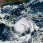
The storm rapidly intensified as it approached landfall, growing into a powerful category four hurricane just about a hundred miles off the coast. Any tropical system in this region has the potential to generate catastrophic flash flooding and mudslides, but this storm’s ferocity made a dangerous situation even worse. News reports indicate that more than a hundred people may have died in the region as a result of the storm’s flooding.
Environmental winds beneath ridges of high pressure are usually pretty calm. The lack of steering currents forced Eta to putter over Central America for a couple of days, slowly weakening as it turned north over Honduras. After entering the western Caribbean two days after landfall, the system regenerated into a tropical storm and drifted north over Cuba as it approached Florida.
This is where the track got a little…creative.
A large ridge of high pressure over the eastern United States and western Atlantic effectively blocked Eta from continuing out into the Atlantic after it crossed over Cuba. This forced the storm to make a westward hook into Florida, making landfall at Lower Matecumbe Key on November 8.
As the ridge moved eastward, Eta slowed to a crawl over the southeastern Gulf of Mexico. The storm slowly drifted toward the tip of Cuba before an approaching trough forced Eta to start moving northeastward. The tropical storm briefly restrengthened into a hurricane as it moved parallel to the west coast of Florida—winds were strong enough in the Tampa area to generate coastal flooding from storm surge.
Eta made its fourth landfall in Florida’s Big Bend region on Thursday morning, and the system will accelerate out to sea and dissipate as it gets swept up by a cold front moving over the eastern United States.
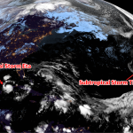
This isn’t the end of it. We’re likely going to see our 30th named storm of the season form in the Caribbean by this weekend, possibly threatening the same stretch of Central America hit by Eta last week.
You can follow me on Twitter or send me an email.
Please consider subscribing to my Patreon. Your support helps me write engaging, hype-free weather coverage—no fretting over ad revenue, no chasing viral clicks. Just the weather.