Snow, Ice, And Bitter Cold: This Is A Storm The South Will Talk About For Decades


The winter storm moving over the southern United States has all the hallmarks of one of those storms that people talk about for decades. The system will bring significant amounts of snow and ice to areas that don’t typically see this kind of wintry weather, and the cold air that follows the storm is on a level the region hasn’t seen in more than 30 years.
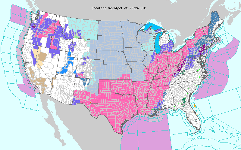
Meteorologists spent Sunday ogling at the National Weather Service’s map of watches, advisories, and warnings across the country:
 |
| Source: NWS |
That huge swath of pink is a winter storm warning. It covers the entire states of Texas, Oklahoma, and Arkansas, along with most of Louisiana and Mississippi, and continues on into the Northeast. The criteria for a winter storm warning changes from one office to the next based on what a region is used to during a typical winter. Any amount of snow and ice warrants a winter storm warning in parts of Texas, while it takes many inches of snow to trigger the same alert up north.
It takes lots of things going juuust right for such an intense winter weather event to stretch so far south. The cold air is rooted in the infamous polar vortex. I explained the process more in-depth last week, but a disruption in the polar vortex circulation over the Arctic allowed a piece of the vortex to break off and sit over the Upper Midwest. This disruption allowed cold air to flow straight out of the Arctic and park itself over the central United States for a couple of weeks.
Meanwhile, an upper-level trough moving out of the Rockies led to the development of a low-pressure system over the southern Plains. Conditions are deteriorating across Texas tonight as the low organizes and snow, sleet, and freezing rain fill in. The low will strengthen and move northeast over the next 48 hours, bringing plenty of wintry precipitation from the Gulf Coast to interior New England.

Here’s the National Weather Service’s snowfall forecast through Wednesday evening. Widespread totals of 6-12″ are possible from northern Texas to northern Maine and just about everywhere in between. Forecasters expect the greatest totals in central Oklahoma and central Arkansas, where some communities could wind up with more than a foot of snow by the end of the storm.
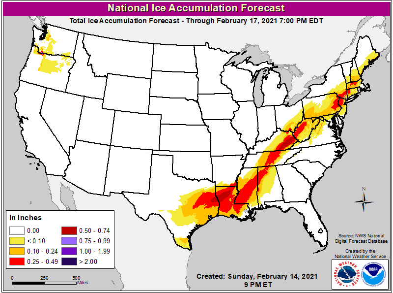
Freezing rain will fall closer to the track of the low. A significant ice storm is possible in Louisiana, Mississippi, Tennessee, and along the Appalachians. Down south, this could be the worst ice storm in memory for many folks.
 |
| Source: NWS |
Everywhere shaded red on the map above could see more than one-quarter of an inch of ice accretion. Some areas could see one-half to three-quarters of an inch of ice, which will cause significant damage.
One thing to keep in mind is that there really isn’t much infrastructure in this part of the country to deal with significant amounts of snow and ice. This isn’t a situation like North Carolina falling apart when it snows. We see snow and ice frequently enough that it’s a shame we can’t handle it better than we do.
This is all the way down south. They don’t have many snow plows or salt/sand/brine trucks to go around. Most people don’t have snow shovels at home or ice scrapers in their cars. You’re lucky if you just happen to have sand or rock salt on hand. The region doesn’t see winter weather enough to justify spending the money to have an infrastructure in place to deal with it.
As if the snow and the ice isn’t bad enough, tonight’s cold is only going to get colder. This winter storm will drag the Midwest’s frigid air all the way to the Gulf of Mexico, allowing temperatures to plummet on Monday and Tuesday.
Here are the National Weather Service’s high and low temperature forecasts for Monday, Tuesday, and Wednesday:

Bitterly cold air will surge as far as northern Mexico, with low temperatures in the single digits approaching the suburbs of San Antonio. It hasn’t been this cold across these regions since December 23, 1989, when it hit -2°F in Fort Worth, 0°F in Waco, 8°F in San Antonio, and a comfy 14°F in Houston.
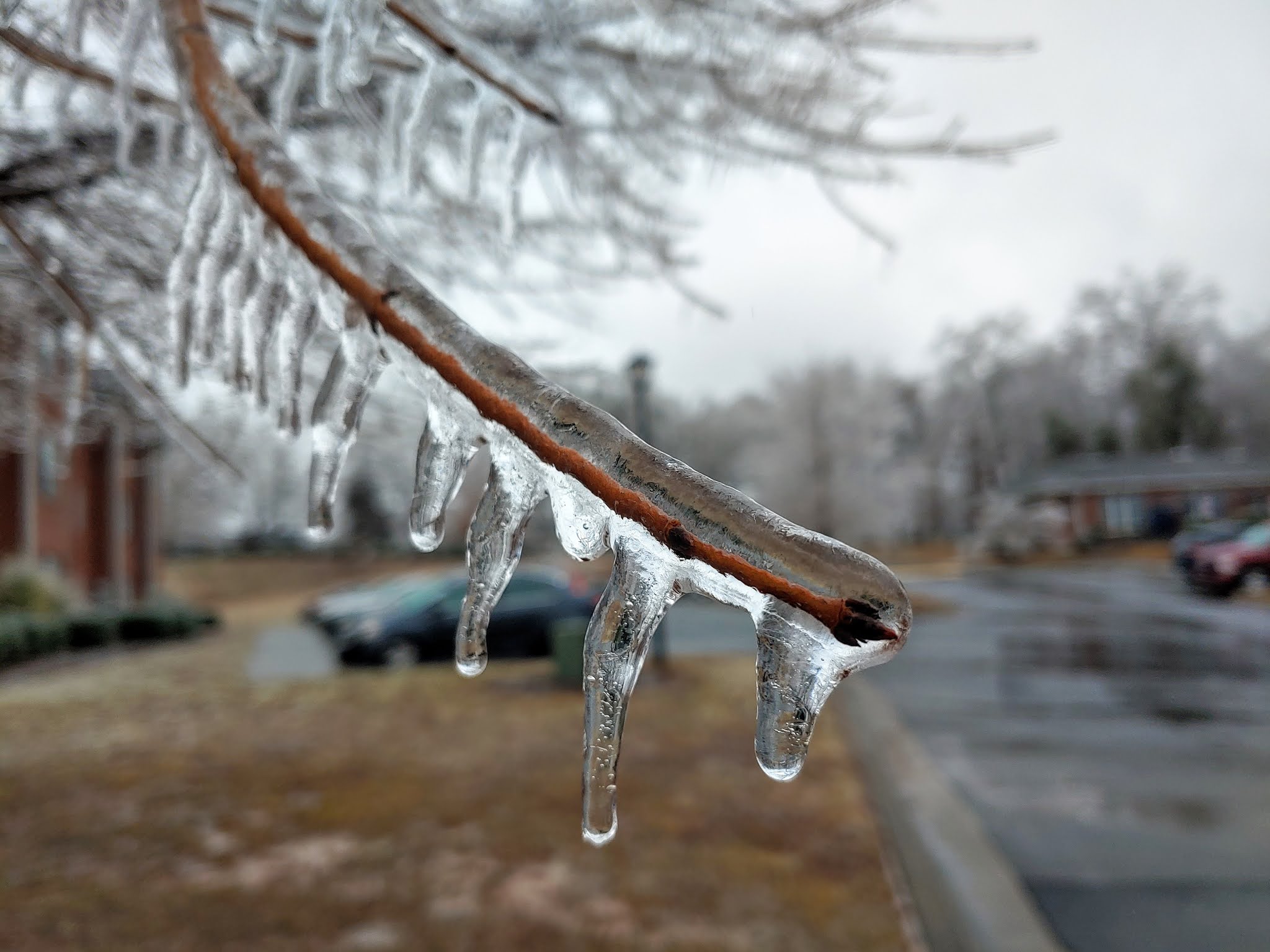
Between the snow, the freezing rain, and the surge in demand due to the frigid temperatures, the region will probably experience a tremendous number of power outages this week. Some communities will probably go without power for a week or longer in extreme cases. Trees in places like Louisiana and Mississippi aren’t accustomed to the weight of ice on their branches and limbs. It won’t take much ice—maybe not even one-quarter of an inch—to bring down limbs and cause trees to snap in half.
 |
| I took this photo just a few minutes after a tree snapped and knocked out the power for 28 hours. |
Don’t take the threat for prolonged power outages lightly. If you follow me on Twitter, you probably saw that we were without power for 28 hours in my town near Greensboro, North Carolina, after about a third of an inch of ice overnight Friday into Saturday. I try to stay as prepared as I preach when it comes to having the supplies needed to get through an extended outage and it was still tough to get enough battery power and warmth to make it through more than 24 hours in the dark.
It’s probably a little too late to get ready now, but if you’re in a position where you still have time to prepare, make sure you’ve got enough batteries, flashlights, water, and non-perishable, ready-to-eat food to get through several days without power. Bottled water (or containers filled with water) are a mainstay on preparedness lists because municipal water treatment plants can lose power as well, potentially hampering their ability to treat or pump water out to you. (It’s no joke. My town is under a boil water advisory for two days!)
Oh, and one more thing—if you live in an area expecting ice, stay away from parts of the house where trees and limbs could fall into the roof or walls. It’s something people don’t really think about until it’s too late. Trees are heavy and houses are comparatively weak. Lots of injuries and deaths during ice storms are caused by trees falling into homes.
You can follow me on Twitter or send me an email.
Please consider subscribing to my Patreon. Your support helps me write engaging, hype-free weather coverage—no fretting over ad revenue, no chasing viral clicks. Just the weather.