Prepare Now For A Potential Tropical System In The Gulf This Weekend


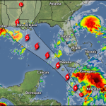
A tropical disturbance in the Caribbean Sea has a high chance of developing into a tropical cyclone over the next couple of days as it moves toward the Gulf of Mexico. The system is likely to strengthen in the Gulf as it approaches land late this weekend or early next week. While it’s still too early for many specifics, this is the time to prepare and be aware.
The disturbance, dubbed Invest 99L by the National Hurricane Center for tracking purposes, is an open tropical wave in the southern Caribbean Sea. The system isn’t much more than a loose collection of scattered thunderstorms over open waters.

The disturbance is moving northwest toward the Yucatan, and conditions should be favorable for the system to develop into a tropical depression or a tropical storm over the next day or two.
Here’s what we know (and don’t know) right now.
Timing
This is going to unfold relatively quickly. We don’t have a week and a half to watch the storm like we would if it traversed the Atlantic. The rapid pace at which this system will likely develop will reduce the amount of time folks along the Gulf Coast and inland will have to prepare.
Right now, it looks like we could see the system approach the U.S. as early as Saturday night or Sunday.
Strength and Landfall
Right now, it looks like the system will generally head toward the northern Gulf Coast.
It’s the end of August, the Gulf is warm, and the atmosphere around the system would be favorable for strengthening, so it’s not unreasonable to say it could be a hurricane by the time it approaches the area—if it develops, of course.
The tricky part of tracking tropical disturbances that haven’t formed yet is, well…they haven’t formed yet. The models are tracking a storm that doesn’t yet exist.
But all storms have to start somewhere, and most models are on board with this disturbance getting its act together in a hurry toward the weekend.
Once the system develops—with a structure and a defined center of circulation—models (and forecasters!) will get a better idea of where the storm will go and how much it’ll intensify before it gets there.
This storm’s name would be either Ida or Julian, depending on whether this develops before or after another disturbance out in the central Atlantic.
Potential Impacts
Strong winds, a dangerous storm surge, widespread flooding from heavy rainfall, and tornadoes would be major hazards along and near the storm’s eventual path. It’s tough to talk about the specifics until the system actually forms.
Power outages are always a major issue with a landfalling storm, even hundreds of miles inland from the point of landfall.
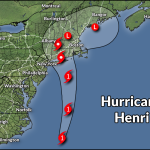
Use this time to prepare for a potential storm. As I said last week when Henri first looked like it might head toward the Northeast:
Do you have flashlights and batteries? How about non-perishable food that doesn’t need to be cooked? Ravioli is good straight out of the can, especially when the power is out and you’re tired of potato chips.
Don’t forget all the things we don’t think about until we need them, like personal hygiene supplies, medicines, cash if you can afford it (cards don’t work if the power’s out), and battery backups for your cell phone.
Take a look at what trees loom near your house. If there are any trees or tree limbs that could fall into your home during high winds, take the time to trim them or remove them now. A significant number of injuries and deaths during a tropical cyclone are the result of trees falling into homes.
If you live in a flood zone, make some plans for what you’ll do if you have to deal with flash flooding in the next couple of days. Do you have somewhere to go, or an escape plan if you need to evacuate in a hurry?
Keep in mind that we’re in the middle of a sharp rise in COVID cases as the Delta variant spreads across the country. Folks who are immunocompromised or otherwise vulnerable to severe illness from COVID might want to consider alternate plans if they consider evacuation shelters too risky.
Check the National Hurricane Center and your local National Weather Service office frequently over the next few days. This is the time to pay attention and prepare. If the storm forms and heads your way, you’re ready. If not, then you’re ready for the next threat.
You can follow me on Twitter or send me an email.
Please consider subscribing to my Patreon. Your support helps me write engaging, hype-free weather coverage—no fretting over ad revenue, no chasing viral clicks. Just the weather.