Dangerous Fire Weather Outbreak Likely In Colorado And New Mexico On Friday

Conditions will be ripe for extreme wildfire growth and behavior across parts of Colorado and New Mexico on Friday, capping off an already-bad week for wildfires across the Front Range and the desert southwest. High winds, blowing dust, and a risk for severe storms will make a bad situation even worse. Use extreme caution over the next few days and be ready to evacuate on a moment’s notice if you fall under an order.
A low-pressure system will develop on the lee side of the Rockies early Friday morning and slowly begin to lift across the central and northern Plains through the day. Winds will pick up in a hurry as the low organizes and gathers strength, allowing temperatures to rise and humidity levels to plummet.
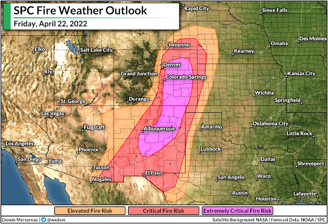
We’re likely to see “extremely critical” fire weather conditions across a swath of Colorado and New Mexico, according to the Storm Prediction Center, which is the highest category on the agency’s fire weather outlook.
It won’t take much to spark a wildfire that grows out of control. The combination of high winds, warm temperatures, and very dry air will work together with an ongoing drought to make conditions highly susceptible to the ignition and spread of even the tiniest fire. Much of the region under the threat for significant fire activity on Friday is going through a severe drought or worse.
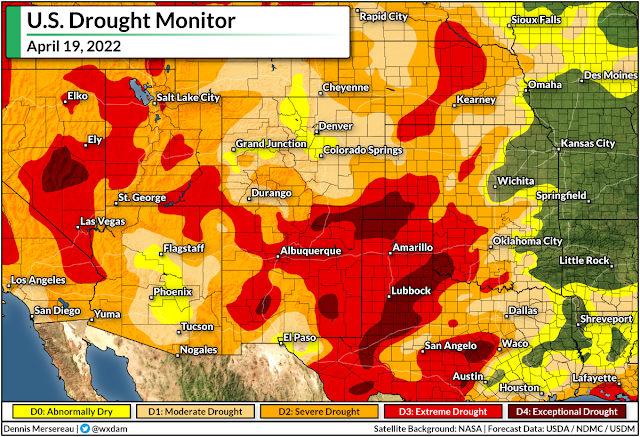
Keep in mind all the typical tips: don’t flick cigarettes on the ground, don’t drive or park on tall grass, don’t start any fires, and avoid any activity that can lead to embers or sparks.
If you live in an area prone to wildfires, it’s a good idea to get all your emergency supplies and important items/documents in order in case you have to evacuate in a hurry. You could have little to no notice ahead of a fast-moving fire. Make sure you’re ready to get up and go at a moment’s notice if you’re ordered to do so.
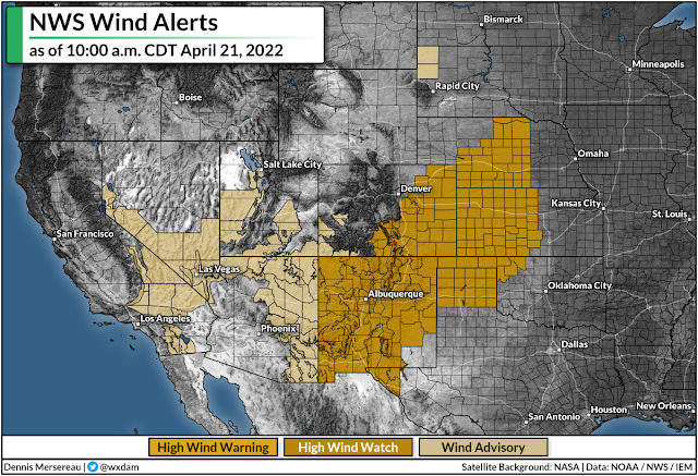
The hazards won’t stop at the risk for wildfires. High wind warnings stretch from southern New Mexico to central Nebraska in advance of winds that will likely gust higher than 60 mph. These winds could lead to downed trees, power outages, and blowing around small debris.
High winds could also whip up dust storms across the region. Blowing dust is a serious safety issue, not only for folks with respiratory problems, but the sudden burst of near-zero visibility can lead to life-threatening highway pileups.
If you have to drive through the region, check to make sure your phone’s emergency alerts are activated. The NWS sends out emergency alerts for dangerous dust storms just as they do for tornado warnings.
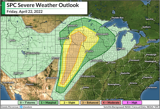
We also have to contend with a risk for severe weather heading into the weekend.
Strong thunderstorms are likely to develop along and ahead of the system’s cold front as it pushes across the central and northern Plains. The wide-reaching risk for severe thunderstorms will stretch from western Texas to northern Minnesota, including Wichita, Omaha, Sioux Falls, and Minneapolis.
There’s enough instability and wind shear present for any thunderstorms to turn severe and produce damaging winds, large hail, and even a few tornadoes. The threat for tornadoes is greatest along the Texas/Oklahoma Panhandles, western Kansas, and near the center of the low in western South Dakota. Some of the supercells on Friday could produce hail the size of golf balls or larger in western Texas, the Oklahoma Panhandle, and southwestern Kansas.
Given the slow forward motion of the low-pressure system as it pushes north into Canada, the threat for severe thunderstorms will only shift slightly east for the day on Saturday.
You can follow me on Twitter or send me an email.
Please consider subscribing to my Patreon. Your support helps me write engaging, hype-free weather coverage—no fretting over ad revenue, no chasing viral clicks. Just the weather.