Agatha To Hit Mexico As A Major Hurricane, Gulf Development Possible Next Week

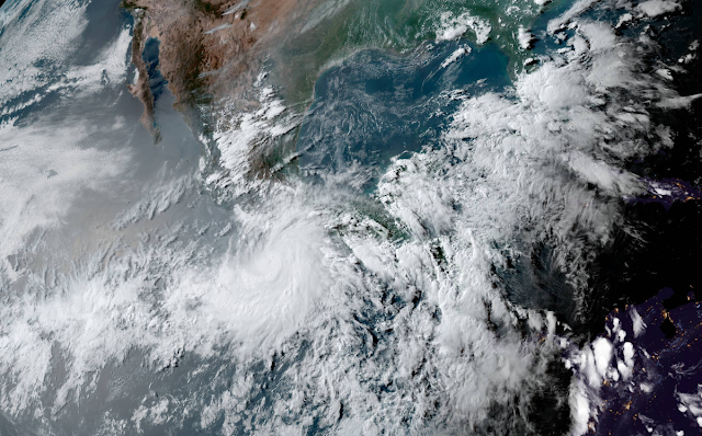
The first storm of the 2022 eastern Pacific hurricane season is going to be a doozy for folks along the southern Mexican coast. Hurricane Agatha is on track to make landfall as a major category three storm late on Monday, bringing prolific rainfall and destructive winds to the Oaxacan coast.
From there, the system’s remnants could redevelop in the Gulf of Mexico as we head into the first week of June.
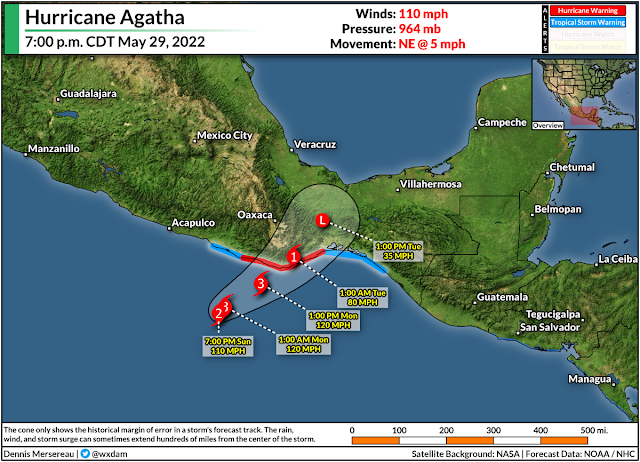
The latest advisory from the National Hurricane Center found Hurricane Agatha on the cusp of major hurricane status. The storm had maximum sustained winds of 110 mph as it crept northeast toward the Oaxacan coast. Hurricane warnings are up for Puerto Escondido and Salina Cruz as the system’s powerful core draws closer to land.
Hurricane Agatha’s intensity, slow movement, and the region’s mountainous terrain will combine to lead to a life-threatening risk for flash flooding and mudslides along the storm’s track.
The NHC’s advisory on Sunday evening called for widespread rainfall totals of a foot or more, with some areas potentially picking up as much as 20 inches of rain by the end of the storm. Most tropical cyclone deaths in this region are the result of flooding and mudslides.
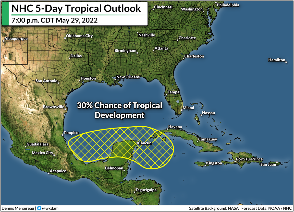
Agatha is going to weaken quickly after it makes landfall, winding down to a remnant low by Tuesday. After that, we’ll have to keep an eye on the hurricane’s remnants for potential redevelopment in the Gulf of Mexico or western Caribbean by the middle of next week.
The NHC’s tropical weather outlook calls for a 30 percent chance of tropical development over the next five days. Models are consistently showing…something…forming in the region and heading toward southern Florida.
Whether or not it’s a full-blown tropical system or just a disturbance remains to be seen, but regardless of development, this surge of tropical moisture will contribute to more heavy rain over southern Florida.
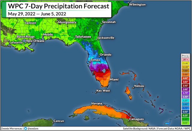
The Weather Prediction Center‘s precipitation forecast for the next seven days calls for 5+ inches of rain across southern Florida, and that’s on top of the heavy rain that’s fallen in today’s heavy thunderstorms.
These totals are likely to fluctuate over the next few days as forecasters get a better handle on the system’s ultimate track and development. A stronger, more organized system could produce more rainfall.
While there are abnormally dry and moderate drought conditions scattered throughout the southern half of Florida, this much rain falling in such a short period of time does more harm through flooding than good through drought amelioration.
Check It Out: Hurricane Maps And Stats 2015-2021
Hurricane season officially begins on June 1st. It looks like this is going to be the first hurricane season in seven years not to start in May or earlier.
Even though we didn’t get a head start for the first time in a long while, forecasters expect an active hurricane season thanks to La Niña over in the eastern Pacific. Cooler sea surface temperatures in the eastern Pacific serve to lessen wind shear over the Atlantic basin, creating more favorable conditions for tropical development throughout the season.
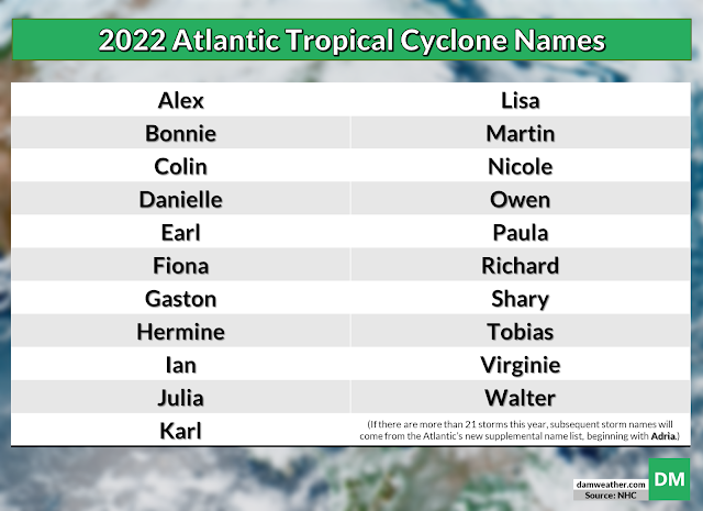
This year’s list of hurricane names was last used in 2016. The first storm on the list will be Alex, followed by Bonnie and Colin. The names Martin and Owen are new this year, replacing Matthew and Otto, which were retired after the 2016 hurricane season.
If we see more than 21 storms before the end of the year, we’ll roll over to the new supplement list of storm names, beginning with the name Adria. The World Meteorological Organization nixed the use of Greek letters to name excess storms after the historic 2020 hurricane season.
You can follow me on Twitter or send me an email.
Please consider subscribing to my Patreon. Your support helps me write engaging, hype-free weather coverage—no fretting over ad revenue, no chasing viral clicks. Just the weather.