Hurricane Warnings Continue As Sprawling Nicole Nears Florida Landfall

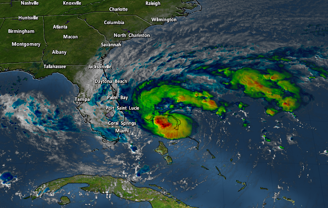
Nicole is on the verge of hurricane strength this afternoon as the storm steadily pushes west through The Bahamas. Forecasters expect then-Hurricane Nicole to make landfall along Florida’s east coast on Wednesday night, gradually pushing across the peninsula through the day on Thursday.
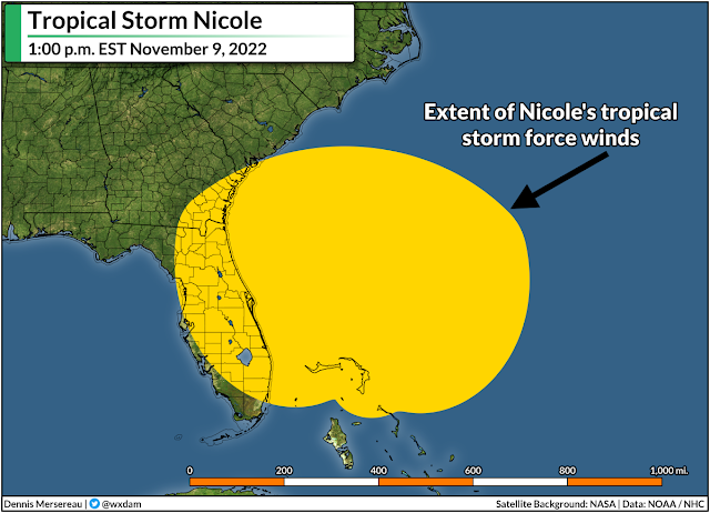
This is an odd storm compared to most tropical systems that Florida is used to dealing with. It’s late in the season, for one, and Nicole didn’t start its life as a purely tropical system. The storm’s subtropical origins made it a very large system, so it’s swirling toward land as a sizeable storm with a footprint to match.
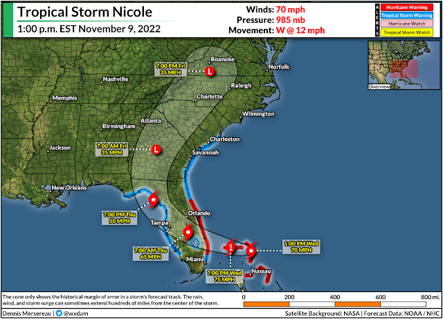
Nicole’s tropical storm force winds extend almost 500 miles from the center of the storm, so this system will have far-reaching impacts regardless of where the very center of the storm makes landfall. The National Hurricane Center expects Nicole to emerge in the eastern Gulf of Mexico on Friday, making its final landfall on the Panhandle before racing inland through the weekend.
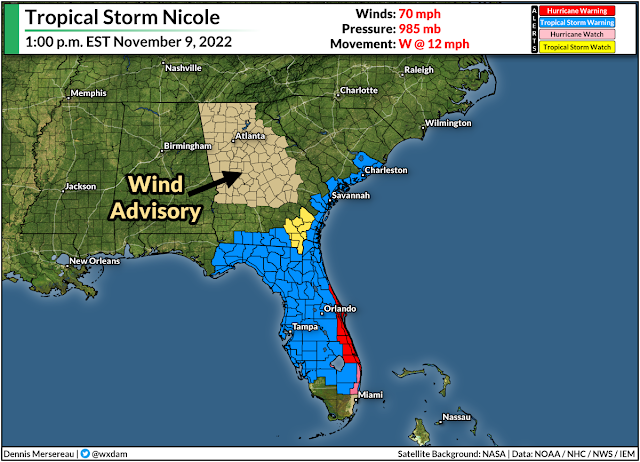
Hurricane warnings are in effect for much of eastern Florida ahead of Nicole’s landfall on Wednesday night. Tropical storm warnings blanket most of Florida, all of coastal Georgia, and reaching coastal South Carolina about halfway between Charleston and Myrtle Beach. A wind advisory is in effect for much of interior Georgia, and it stands to reason that more wind advisories will pop up over the next 24 hours.
Again…big storm.
Widespread gusty winds will lead to downed trees and power outages across the southeastern U.S. over the next couple of days. There were only about 6,500 power outages across Florida by noon on Wednesday, but that number will tick upward as the core of the storm draws closer through the day. The storm’s effects won’t stop at the coast, of course. Nicole’s size and path will make power outages and spotty wind damage likely throughout inland sections of Georgia and the Carolinas.
Storm surge warnings are in effect for much of the coast ahead of Nicole’s landfall. The NHC’s latest forecast calls for up to 3-5 feet of storm surge along most of Florida’s east coast if the peak surge coincides with high tide, with up to 2-4 feet of storm surge possible up to Charleston, S.C., in the same scenario.
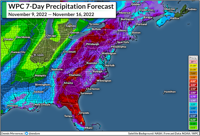
Heavy rains will follow the storm inland through the weekend. There’s a slight risk for flash flooding along the storm’s path as it treks inland across the East Coast over the next couple of days. This isn’t going to be a blockbuster rainfall event. We’ll see a big swath of 1-3 inches of rain along Nicole’s path, with locally higher amounts possible. Some flooding issues are possible in vulnerable areas. Leaves clogging storm drains could lead to additional flooding on some roads and parking lots.
There’s also a risk for severe weather across eastern sections of Florida, Georgia, and the Carolinas. As with any landfalling storm, the eastern side of the system is ripe for rotating thunderstorms that could produce quick tornadoes. Tropical tornadoes happen quickly and with reduced tornado warning lead time, so make sure you have a way to receive warnings the moment they’re issued.
Once Nicole (and the cold front sweeping it along) clear away from the East Coast this weekend, it’s going to be a much quieter—and much colder—pattern settling in next week. Daytime highs only reaching the 40s will dip deep into the southeastern states. Gotta love late fall.
[Top image created using WSV3]
You can follow me on Twitter or send me an email.
Please consider subscribing to my Patreon. Your support helps me write engaging, hype-free weather coverage—no fretting over ad revenue, no chasing viral clicks. Just the weather.