Skip to content
DAMWeather DAMWeather DAMWeather

The weather can get scary. Reporting on it doesn't have to be.

DAMWeather DAMWeather DAMWeather

The weather can get scary. Reporting on it doesn't have to be.

  • About Me
  • All Bylines
    • Books, Bylines, and Press
    • The Skies Above (Book)
    • Extreme Weather (Book)
    • The Weather Network
    • The Vane
    • Forbes
    • Capital Weather Gang
    • Mental Floss
  • Maps
    • Hurricane Maps
    • Hurricane Names
    • Monthly Tornadoes
    • Tornado Tracks
    • F5/EF-5 Tornadoes
    • SPC High Risk Days
  • GIS Resources
  • Contact Me
    • Bluesky
    • Facebook
    • Instagram
  • wxdam.com
  • About Me
  • All Bylines
    • Books, Bylines, and Press
    • The Skies Above (Book)
    • Extreme Weather (Book)
    • The Weather Network
    • The Vane
    • Forbes
    • Capital Weather Gang
    • Mental Floss
  • Maps
    • Hurricane Maps
    • Hurricane Names
    • Monthly Tornadoes
    • Tornado Tracks
    • F5/EF-5 Tornadoes
    • SPC High Risk Days
  • GIS Resources
  • Contact Me
    • Bluesky
    • Facebook
    • Instagram
  • wxdam.com
Close

Search

2023’s First Moderate Severe Storm Risk Targets Oklahoma With 75+ MPH Winds

By Dennis Mersereau
February 25, 2023 2 Min Read

This year’s first big threat for severe weather will target Oklahoma this weekend as forecasters expect a dangerous squall line to sweep across much of the state on Sunday.
A robust low-pressure system will develop over the central Plains this weekend as a trough crests the Rockies. This is the same trough responsible for all that wild snow in California—that’s a lot of energy heading east.
Plenty of warm, humid air bathed over the southern Plains will provide ample fuel for vigorous thunderstorms to develop along and ahead of this low-pressure system’s cold front through the day Sunday.
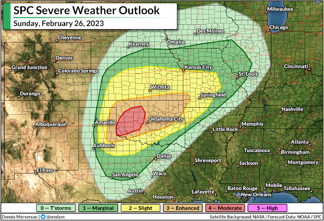
There’s enough wind shear that forecasters with the Storm Prediction Center expect a powerful line of thunderstorms to develop along the front. They’ve issued a moderate risk—a 4 out of 5 on the scale measuring the threat for severe weather—for a chunk of western Oklahoma, with an enhanced risk extending east to cover the rest of the state into southwestern Missouri.
This is the highest risk issued by the SPC since December, and it’s especially noteworthy because it’s for Day 2—they usually wait until the day of the event to upgrade to a high-end risk, a move that conveys their confidence in widespread severe storms on Sunday.
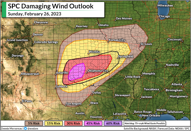
Damaging winds in excess of 75 mph are the main threat with the storms on Sunday, covering the Oklahoma City and Tulsa metro areas, as well as Joplin and Springfield in southwestern Missouri.
Widespread severe wind gusts can cause tree damage and power outages. Folks are often taken by surprise by the strength of severe squall lines, swearing that they witnessed a tornado or “inland hurricane” instead of a line of bad storms.
In addition to the risk for widespread damaging winds, we could see tornadoes develop within the squall line and in any discrete thunderstorms that bubble up ahead of it. Tornadoes embedded in squalls can happen very quickly, sometimes reducing tornado warning lead time down to a few minutes at best.
Folks on the Plains are well versed in tornado safety, but given that it’s February and these tornadoes could happen quickly, it’s worth taking a few minutes to prepare.
Make sure you (or anyone you know in the area) has a way to receive warnings and get to safe shelter the moment they’re issued. Take a look at your phone’s settings and ensure that wireless emergency alerts are turned on and activated for tornado warnings.


You can follow me on Facebook, Mastodon, Twitter, Instagram, or send me an email.

Please consider subscribing to my Patreon. Your support helps me write engaging, hype-free weather coverage—no fretting over ad revenue, no chasing viral clicks. Just the weather.


Author

Dennis Mersereau

I have 15+ of experience providing hype-free weather information for folks across the United States and around the world. In addition to DAMWeather, I also contribute to The Weather Network as a digital writer and weather specialist.

Follow Me
Other Articles
Previous

Thursday Could Be One Of The Southeast’s Hottest February Days On Record

Next

Another Atmospheric River Hits California As New England Deals With A Nor’easter


Local ◈ UTC
Facebook | Bluesky
Instagram | Threads | Email
DAMWeather is now ad-free! Everyone benefits from engaging, hype-free weather coverage. Please consider supporting my efforts through Patreon:


Order The Skies Above today!

Bookshop.org || Barnes & Noble
Mountaineers Books || Amazon

My latest book, The Skies Above, is now available!

Did you know a puffy cloud can weigh millions of pounds? Or that every rainbow you see is unique to you?

Our atmosphere is full of spectacular sights that are always within your reach. Glistening layers of fog, gorgeous sunsets, and brilliant meteors flashing through the sky can light up even the calmest day.

The Skies Above, published by Mountaineers Books, is a celebration of what we overlook when we look up. I was thrilled to work with the editors and illustrators at Indelible Editions to share with you the quotidian beauty of our sky.

Order your copy now and learn about the wonders we take for granted every day.

I teamed up with the editors of Outdoor Life magazine to write The Extreme Weather Survival Manual, your guide to surviving and thriving in almost any weather condition. Whether you're an avid outdoorsperson or you enjoy watching the radar from the comfort of your home, you're sure to find helpful tips, advice, and new bits of knowledge in this fascinating book.

You can buy my book today through Amazon.
  • 2026 (34)
  • 2025 (49)
  • 2024 (59)
  • 2023 (43)
  • 2022 (57)
  • 2021 (71)
  • 2020 (83)
  • 2019 (88)
  • 2018 (92)
  • 2017 (1)
  • 2016 (4)
  • 2015 (10)

Copyright 2026 — DAMWeather. All rights reserved. Blogsy WordPress Theme