Widespread Severe Weather Expected Friday Across The Central U.S.

A classic springtime system rolling across the northern U.S. will lead to a widespread risk for severe weather across the middle of the country on Friday.
We’ve had some potent severe weather already this year—including a devastating EF-4 tornado in Mississippi last week—but this is the widest-ranging severe storm risk we’ve seen so far this season.
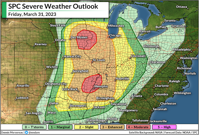
The Storm Prediction Center (SPC) expects severe thunderstorms on Friday from east-central Texas all the way into central Wisconsin, stretching as far east as the Ohio River Valley through the overnight hours into Saturday.
A strong Colorado low sweeping across the Upper Midwest on Friday will sow the seeds for this potential severe weather outbreak. Unstable air streaming north into the low will provide the instability, and powerful upper-level winds will supply the wind shear needed to turn thunderstorms severe.
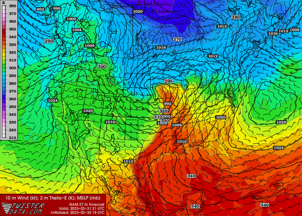 |
| Source: TwisterData.com |
As with most classic springtime severe weather outbreaks, we’ll see the hazards play out in two distinct rounds. The initial thunderstorms have the best opportunity to grow into supercells capable of producing strong, long-lived tornadoes, as well as large hail and damaging winds.
These supercells are most likely in and around the two moderate risk areas: near the center of the low in Iowa, and near the greatest instability and wind shear over the Mid-South.
As the day wears on, a lengthy squall line will develop along an approaching cold front, transitioning the threat to widespread damaging wind gusts (60+ mph) and the potential for fast-spawning tornadoes in the kinks along the leading edge of the line. This line will push east late Friday through the overnight hours.
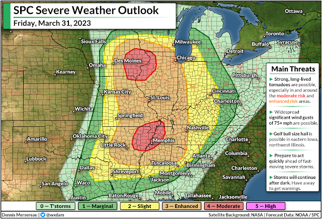
A large area falls under an enhanced risk for severe weather, or a 3 out of 5 on the scale measuring the potential extent of powerful thunderstorms. Two separate areas are under a moderate risk, or a 4 out of 5 on the scale, including eastern Iowa and northwestern Illinois, as well as the Mid-South centered around Memphis.

Strong, long-lived tornadoes are possible throughout most of the Mississippi River Valley between Dubuque, Iowa, and Clarksdale, Mississippi, with the potential for significant tornadoes pushing east into central Tennessee and northern Alabama.
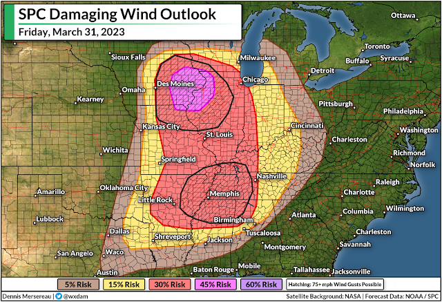
Tornadoes get top billing on red-letter severe weather days, of course, but damaging wind gusts—potentially reaching 75+ mph—are far and away the most immediate threat to any one location. These winds can cause as much damage as a tornado, just over a wider area.
Keep a close eye on watches and warnings if you live in the region, and let your friends and family know to do the same if they’re under any severe weather risk on Friday. Have a plan in place to seek sturdy shelter in a hurry if a warning is issued for your location, whether you’re at home, work, school, or out running errands.
The threat for severe weather will shift east on Saturday, albeit on a much weaker scale as the low-pressure system lifts into Quebec. Damaging winds and a couple of tornadoes will be possible across parts of the southeastern states, as well as a damaging wind threat in any storms that pop up across the eastern Great Lakes.
Another storm next week could produce significant severe weather across many of the same areas expecting bad storms on Friday. It’s that time of year. Stay ready, and stay alert.

You can follow me on Facebook, Mastodon, Twitter, Instagram, or send me an email.
Please consider subscribing to my Patreon. Your support helps me write engaging, hype-free weather coverage—no fretting over ad revenue, no chasing viral clicks. Just the weather.