Skip to content
DAMWeather DAMWeather DAMWeather

The weather can get scary. Reporting on it doesn't have to be.

DAMWeather DAMWeather DAMWeather

The weather can get scary. Reporting on it doesn't have to be.

  • About Me
  • All Bylines
    • Books, Bylines, and Press
    • The Skies Above (Book)
    • Extreme Weather (Book)
    • The Weather Network
    • The Vane
    • Forbes
    • Capital Weather Gang
    • Mental Floss
  • Maps
    • Hurricane Maps
    • Hurricane Names
    • Monthly Tornadoes
    • Tornado Tracks
    • F5/EF-5 Tornadoes
    • SPC High Risk Days
  • GIS Resources
  • Contact Me
    • Bluesky
    • Facebook
    • Instagram
  • wxdam.com
  • About Me
  • All Bylines
    • Books, Bylines, and Press
    • The Skies Above (Book)
    • Extreme Weather (Book)
    • The Weather Network
    • The Vane
    • Forbes
    • Capital Weather Gang
    • Mental Floss
  • Maps
    • Hurricane Maps
    • Hurricane Names
    • Monthly Tornadoes
    • Tornado Tracks
    • F5/EF-5 Tornadoes
    • SPC High Risk Days
  • GIS Resources
  • Contact Me
    • Bluesky
    • Facebook
    • Instagram
  • wxdam.com
Close

Search

Widespread severe storms with high winds to sweep across the eastern U.S. on Monday

By Dennis Mersereau
August 7, 2023 3 Min Read

Well, that’s strange.
It’s a little unusual to see such a sprawling risk for severe weather as we approach the middle of August, but a robust system swinging into the eastern United States will trigger multiple lines of severe storms through the day on Monday.
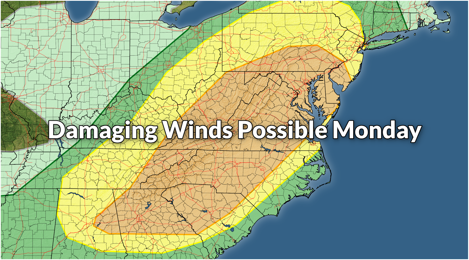
The Storm Prediction Center issued a very large enhanced risk for severe weather—a level 3 out of 5 on the scale measuring the risk for severe storms—stretching from Birmingham to Philadelphia.
Plenty of hot, muggy air parked over the eastern states will provide the fuel needed for thunderstorms to roar through the day Monday, largely sparked by a cold front advancing into this summertime airmass.
Forecasters expect enough instability and wind shear for these storms to organize in a hurry and turn severe. Far and away the greatest threat with these storms will be damaging wind gusts. We’re likely to see the storms develop into numerous squall lines, with each one likely capable of producing 60+ mph wind gusts as they push through.
Storms will likely form west of the Appalachians by the early afternoon Monday, steadily pushing east through the late afternoon and evening hours.
The SPC’s forecast on Sunday showed a very large area at risk for damaging wind gusts on Monday, with the greatest threat concentrated on the I-85/95 corridor from Birmingham north through the Philly area. There’s a decent chance that the strongest storms could approach the D.C. metro area through Monday afternoon and evening.
There’s a chance that some of the discrete thunderstorms—the loners that form on their own, away from the interference of nearby storms—could develop some rotation, bringing with them a threat for large hail and possibly a tornado or two.
We could also see little ‘kinks’ develop along the leading edge of some of the squall lines, bringing the potential for a quick tornado or two embedded within the stronger lines of storms.
Things will calm down once the cold front pushes through, and most folks across Tennessee/North Carolina and northward should enjoy a touch of lower humidity on Tuesday and Wednesday.
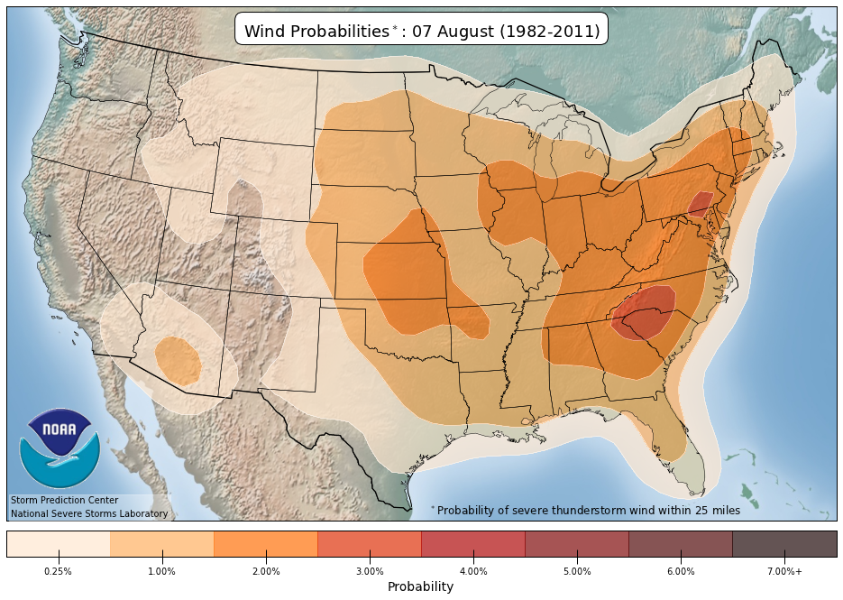
A climatology map showing where damaging winds in severe thunderstorms are common on August 7 in any given year. (SPC)
So…why is this strange, exactly? 
August is usually the doldrums when it comes to weather east of the Mississippi River. Around this time of year, the jet stream is typically all the way north in Canada, allowing any low-pressure systems to swirl through the Plains before lifting north of the international border.
That relative lack of an active pattern leaves the eastern third of the country to the whims of tropical systems in the Atlantic or pop-up thunderstorms fueled by daytime heating—those random storms that bubble up where they may, raging for an hour before fizzling out with the loss of sunlight.
But the pattern over the U.S. and Canada in recent weeks has allowed these robust systems to track farther south than they normally would, essentially creating a setup where we have May-like storm systems tracking into the full-blown August heat.


Follow me on Facebook | Bluesky |
Threads | Instagram | Twitter

Get in touch! Send me an email.

Please consider subscribing to my Patreon. Your support helps me write engaging, hype-free weather coverage—no fretting over ad revenue, no chasing viral clicks. Just the weather.


Author

Dennis Mersereau

I have 15+ of experience providing hype-free weather information for folks across the United States and around the world. In addition to DAMWeather, I also contribute to The Weather Network as a digital writer and weather specialist.

Follow Me
Other Articles
Previous

Highs in the 90s to cover most of the East Coast this week, 100°F possible near D.C.

Next

Southern California faces a serious flash flood threat with Hurricane Hilary


Local ◈ UTC
Facebook | Bluesky
Instagram | Threads | Email
DAMWeather is now ad-free! Everyone benefits from engaging, hype-free weather coverage. Please consider supporting my efforts through Patreon:


Order The Skies Above today!

Bookshop.org || Barnes & Noble
Mountaineers Books || Amazon

My latest book, The Skies Above, is now available!

Did you know a puffy cloud can weigh millions of pounds? Or that every rainbow you see is unique to you?

Our atmosphere is full of spectacular sights that are always within your reach. Glistening layers of fog, gorgeous sunsets, and brilliant meteors flashing through the sky can light up even the calmest day.

The Skies Above, published by Mountaineers Books, is a celebration of what we overlook when we look up. I was thrilled to work with the editors and illustrators at Indelible Editions to share with you the quotidian beauty of our sky.

Order your copy now and learn about the wonders we take for granted every day.

I teamed up with the editors of Outdoor Life magazine to write The Extreme Weather Survival Manual, your guide to surviving and thriving in almost any weather condition. Whether you're an avid outdoorsperson or you enjoy watching the radar from the comfort of your home, you're sure to find helpful tips, advice, and new bits of knowledge in this fascinating book.

You can buy my book today through Amazon.
  • 2026 (34)
  • 2025 (49)
  • 2024 (59)
  • 2023 (43)
  • 2022 (57)
  • 2021 (71)
  • 2020 (83)
  • 2019 (88)
  • 2018 (92)
  • 2017 (1)
  • 2016 (4)
  • 2015 (10)

Copyright 2026 — DAMWeather. All rights reserved. Blogsy WordPress Theme