Skip to content
DAMWeather DAMWeather DAMWeather

The weather can get scary. Reporting on it doesn't have to be.

DAMWeather DAMWeather DAMWeather

The weather can get scary. Reporting on it doesn't have to be.

  • About Me
  • All Bylines
    • Books, Bylines, and Press
    • The Skies Above (Book)
    • Extreme Weather (Book)
    • The Weather Network
    • The Vane
    • Forbes
    • Capital Weather Gang
    • Mental Floss
  • Maps
    • Hurricane Maps
    • Hurricane Names
    • Monthly Tornadoes
    • Tornado Tracks
    • F5/EF-5 Tornadoes
    • SPC High Risk Days
  • GIS Resources
  • Contact Me
    • Bluesky
    • Facebook
    • Instagram
  • wxdam.com
  • About Me
  • All Bylines
    • Books, Bylines, and Press
    • The Skies Above (Book)
    • Extreme Weather (Book)
    • The Weather Network
    • The Vane
    • Forbes
    • Capital Weather Gang
    • Mental Floss
  • Maps
    • Hurricane Maps
    • Hurricane Names
    • Monthly Tornadoes
    • Tornado Tracks
    • F5/EF-5 Tornadoes
    • SPC High Risk Days
  • GIS Resources
  • Contact Me
    • Bluesky
    • Facebook
    • Instagram
  • wxdam.com
Close

Search

Developing tropical system to drench N.C., Mid-Atlantic with soaking rains


By Dennis Mersereau
September 22, 2023 2 Min Read

A system brewing in the southwestern Atlantic Ocean will bring heavy rain and gusty winds to a big chunk of North Carolina and the Mid-Atlantic states beginning Friday and lasting through the weekend.
Localized flooding is possible in areas that see the heaviest rainfall totals, while some areas may deal with power outages as gusts exceed 45 mph in spots. Storm surge flooding is also likely along the coasts of North Carolina and Virginia, which will inundate roads and low-lying communities close to the shore.
An area of disturbed weather just off the southeast coast is likely going to develop into a short-lived tropical storm over the next couple of days.
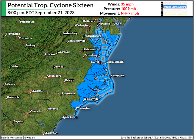
The National Hurricane Center dubbed the system “Potential Tropical Cyclone Sixteen,” a purely bureaucratic title that allows them to issue tropical storm watches and warnings when a disturbance is close to land, but hasn’t developed into an actual tropical system yet.
This disturbance will likely become Tropical Storm Ophelia by Friday night as it approaches a Saturday morning landfall in eastern North Carolina. It’ll continue moving north through the weekend, losing organization as quickly as it developed, but still producing rainy and breezy conditions as it scoots north along the coast.
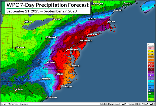
Regardless of its title or development, we’re in for a solid stretch of soaking rains and gusty winds for much of the eastern seaboard between South Carolina and Massachusetts. The latest forecast from the Weather Prediction Center paints 2-4 inches of rain from Myrtle Beach to Boston, with the potential for 5+ inches of rain over eastern North Carolina and southeastern Virginia.
The combination of rain-soaked soil and gusty winds could lead to power outages in some areas.
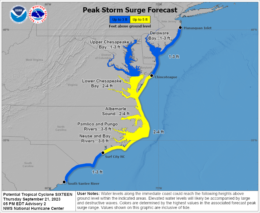
Source: National Hurricane Center

We’re also on the lookout for a not-insignificant storm surge for the North Carolina and Virginia coasts. The latest NHC forecast calls for the potential for 2-4 feet of storm surge along the Outer Banks if the surge coincides with high tide. That’s more than enough to inundate coastal roads and potentially flood nearby communities.

Follow me on Facebook | Bluesky |
Threads | Instagram | Twitter

Get in touch! Send me an email.

Please consider subscribing to my Patreon. Your support helps me write engaging, hype-free weather coverage—no fretting over ad revenue, no chasing viral clicks. Just the weather.


Author

Dennis Mersereau

I have 15+ of experience providing hype-free weather information for folks across the United States and around the world. In addition to DAMWeather, I also contribute to The Weather Network as a digital writer and weather specialist.

Follow Me
Other Articles
Previous

Tropical storm warnings up for New England as Lee approaches this weekend

Next

‘We had no warning’—NYC flash floods test our strained attention economy


Local ◈ UTC
Facebook | Bluesky
Instagram | Threads | Email
DAMWeather is now ad-free! Everyone benefits from engaging, hype-free weather coverage. Please consider supporting my efforts through Patreon:


Order The Skies Above today!

Bookshop.org || Barnes & Noble
Mountaineers Books || Amazon

My latest book, The Skies Above, is now available!

Did you know a puffy cloud can weigh millions of pounds? Or that every rainbow you see is unique to you?

Our atmosphere is full of spectacular sights that are always within your reach. Glistening layers of fog, gorgeous sunsets, and brilliant meteors flashing through the sky can light up even the calmest day.

The Skies Above, published by Mountaineers Books, is a celebration of what we overlook when we look up. I was thrilled to work with the editors and illustrators at Indelible Editions to share with you the quotidian beauty of our sky.

Order your copy now and learn about the wonders we take for granted every day.

I teamed up with the editors of Outdoor Life magazine to write The Extreme Weather Survival Manual, your guide to surviving and thriving in almost any weather condition. Whether you're an avid outdoorsperson or you enjoy watching the radar from the comfort of your home, you're sure to find helpful tips, advice, and new bits of knowledge in this fascinating book.

You can buy my book today through Amazon.
  • 2026 (34)
  • 2025 (49)
  • 2024 (59)
  • 2023 (43)
  • 2022 (57)
  • 2021 (71)
  • 2020 (83)
  • 2019 (88)
  • 2018 (92)
  • 2017 (1)
  • 2016 (4)
  • 2015 (10)

Copyright 2026 — DAMWeather. All rights reserved. Blogsy WordPress Theme