Skip to content
DAMWeather DAMWeather DAMWeather

The weather can get scary. Reporting on it doesn't have to be.

DAMWeather DAMWeather DAMWeather

The weather can get scary. Reporting on it doesn't have to be.

  • About Me
  • All Bylines
    • Books, Bylines, and Press
    • The Skies Above (Book)
    • Extreme Weather (Book)
    • The Weather Network
    • The Vane
    • Forbes
    • Capital Weather Gang
    • Mental Floss
  • Maps
    • Hurricane Maps
    • Hurricane Names
    • Monthly Tornadoes
    • Tornado Tracks
    • F5/EF-5 Tornadoes
    • SPC High Risk Days
  • GIS Resources
  • Contact Me
    • Bluesky
    • Facebook
    • Instagram
  • wxdam.com
  • About Me
  • All Bylines
    • Books, Bylines, and Press
    • The Skies Above (Book)
    • Extreme Weather (Book)
    • The Weather Network
    • The Vane
    • Forbes
    • Capital Weather Gang
    • Mental Floss
  • Maps
    • Hurricane Maps
    • Hurricane Names
    • Monthly Tornadoes
    • Tornado Tracks
    • F5/EF-5 Tornadoes
    • SPC High Risk Days
  • GIS Resources
  • Contact Me
    • Bluesky
    • Facebook
    • Instagram
  • wxdam.com
Close

Search

How an incredible band of snow developed over the Northeast on Saturday

By Dennis Mersereau
February 17, 2024 3 Min Read

One of the most impressive bands of snow we’ve seen in a long time developed over a narrow swath of the Northeast overnight Friday into early Saturday, creating an intense snowfall gradient over very short distances.
A fast-moving low-pressure system tracked out of the Midwest toward the East Coast through the day Friday, producing heavy snow along its path from St. Louis to New York City.
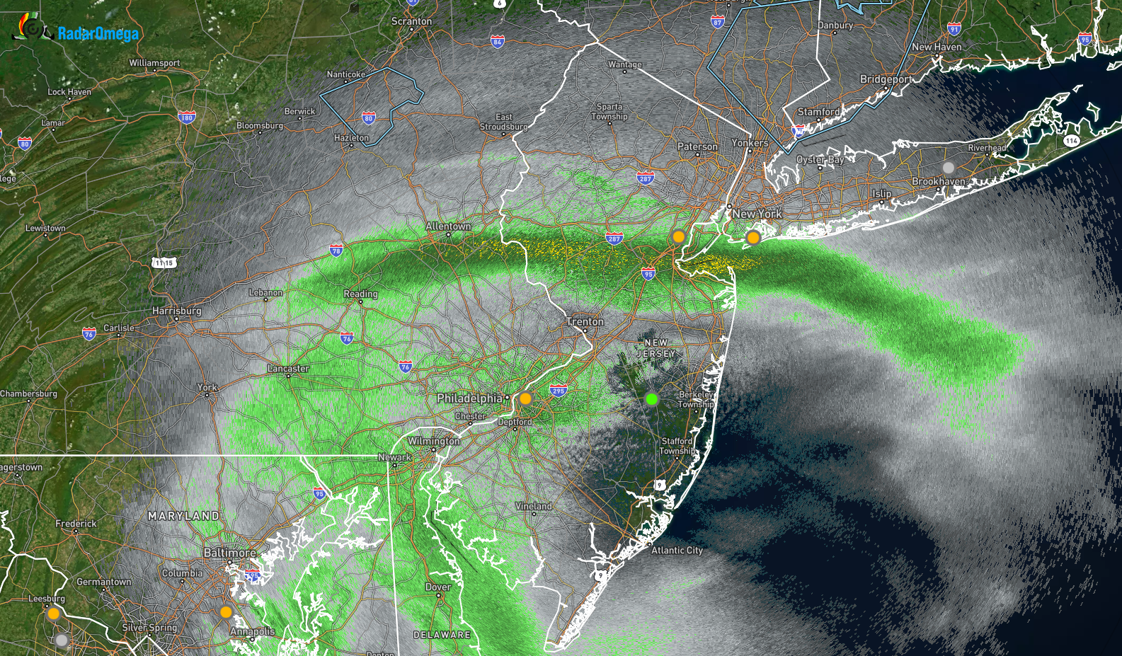
A radar snapshot from around 1:30 a.m on February 17, 2024 (RadarOmega)

This wasn’t an ordinary clipper system, though. While weak systems like this tend drop a few inches of snow before moving on their way, we saw a dramatic band of snow develop on the northern side of the low.
The band left behind enhanced snowfall totals from Indiana to New York, reaching its peak intensity over portions of Pennsylvania and New Jersey. 
A tremendous gradient sliced through Allentown, Pennsylvania, with folks on the south side of town witnessing 13″ of snow while neighborhoods north of town saw just 3″ of snow. Farther east, observers measured 10″ of snow in Brooklyn, while only 2″ of snow fell in Central Park just a dozen miles to the north.
Even more impressive is that parts of New Jersey saw snowfall rates of 5″ per hour at the peak of the snowfall. This kind of convective banding is something more like what you’d see off the Great Lakes rather than eastern Pennsylvania and northern New Jersey. Instead of lake-warmed air fueling intense bands of snow, we saw intense frontogenesis along the northern side of the low.
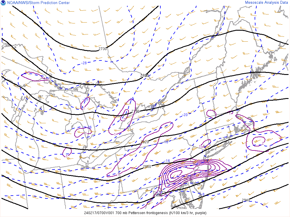
Frontogenesis in the mid-levels of the atmosphere early Saturday morning. (NOAA/SPC)
Frontogenesis occurs when an airmass on the move collides with another airmass nearby. This interaction creates a stretching motion through the atmosphere. Winds slowing down and fanning out leaves a ‘void’ in the atmosphere that air has to rush upward to fill, a rising motion that creates a convective band of very heavy snowfall.
We often see this process during classic nor’easters when a shield of very heavy snow develops on the northwestern side of the storm. But it’s not limited to nor’easters—conditions were just right for this relatively weak system to generate the intense dynamics needed to drop a tremendous amount of snow across a narrow stretch of real estate.


Follow me on Facebook | Bluesky |
Threads | Instagram | Twitter

Get in touch! Send me an email.

Please consider subscribing to my Patreon. Your support helps me write engaging, hype-free weather coverage—no fretting over ad revenue, no chasing viral clicks. Just the weather.


Author

Dennis Mersereau

I have 15+ of experience providing hype-free weather information for folks across the United States and around the world. In addition to DAMWeather, I also contribute to The Weather Network as a digital writer and weather specialist.

Follow Me
Other Articles
Previous

From 60s to Snow: The Northeast’s Nor’easter’s Set To Hit Hard Tuesday

Next

Major, disruptive snowstorm aims for Denver and Colorado Springs


Local ◈ UTC
Facebook | Bluesky
Instagram | Threads | Email
DAMWeather is now ad-free! Everyone benefits from engaging, hype-free weather coverage. Please consider supporting my efforts through Patreon:


Order The Skies Above today!

Bookshop.org || Barnes & Noble
Mountaineers Books || Amazon

My latest book, The Skies Above, is now available!

Did you know a puffy cloud can weigh millions of pounds? Or that every rainbow you see is unique to you?

Our atmosphere is full of spectacular sights that are always within your reach. Glistening layers of fog, gorgeous sunsets, and brilliant meteors flashing through the sky can light up even the calmest day.

The Skies Above, published by Mountaineers Books, is a celebration of what we overlook when we look up. I was thrilled to work with the editors and illustrators at Indelible Editions to share with you the quotidian beauty of our sky.

Order your copy now and learn about the wonders we take for granted every day.

I teamed up with the editors of Outdoor Life magazine to write The Extreme Weather Survival Manual, your guide to surviving and thriving in almost any weather condition. Whether you're an avid outdoorsperson or you enjoy watching the radar from the comfort of your home, you're sure to find helpful tips, advice, and new bits of knowledge in this fascinating book.

You can buy my book today through Amazon.
  • 2026 (34)
  • 2025 (49)
  • 2024 (59)
  • 2023 (43)
  • 2022 (57)
  • 2021 (71)
  • 2020 (83)
  • 2019 (88)
  • 2018 (92)
  • 2017 (1)
  • 2016 (4)
  • 2015 (10)

Copyright 2026 — DAMWeather. All rights reserved. Blogsy WordPress Theme