Prepare now: A hurricane is likely in the Gulf of Mexico this week


A disturbance in the western Caribbean has a very high likelihood of rapidly intensifying into a hurricane over the next couple of days as it closes in on the Gulf Coast.
This isn’t the kind of storm we get to watch for a week and a half before anyone has to take action. This is going to be a very fast developing storm, and we could be less than 72 hours away from dangerous winds and flooding rains beginning to sweep over the southeastern United States.
A Budding Hurricane Is Likely
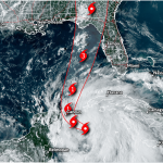
The National Hurricane Center began issuing forecasts on soon-to-be-Helene on Monday afternoon. The agency’s opening bid calls for the storm to rapidly intensify into a hurricane as it enters the Gulf of Mexico over the next 36 hours. The storm could approach major hurricane intensity by the time it makes landfall during the day on Thursday.
A complex pattern of upper-level winds over the United States will affect future-Helene’s path over the next few days. The storm will start to curve northeast once it enters the Gulf of Mexico, likely taking it on a path toward the Florida Panhandle or the state’s Big Bend region.

It’s worth noting that everyone from Tampa to Pensacola is currently in the cone of uncertainty, which is the historical margin of error in the NHC’s track forecasts.
There are several key factors that meteorologists are still struggling with right now. The biggest is that the storm hasn’t actually developed yet. This disturbance is still a disorganized cluster of thunderstorms over the Caribbean. Forecasters and weather models both will have a clearer idea of the storm’s future once it actually develops.
Here are a few potential scenarios we could see over the next few days.
Potential #1: Worst-Case Scenario
The worst-case scenario is that future-Helene will rapidly intensify as it approaches land, strengthening into a major hurricane before it makes landfall on Thursday.

Sea surface temperatures across the Gulf of Mexico are extremely warm, running several degrees above average for the end of September. Warm waters are like rocket fuel to a budding storm.
These warm waters and a favorable environment around the storm could allow future-Helene to rapidly intensify up through landfall on Thursday.
Potential #2: A Dangerous But Weaker Storm
A second realistic scenario is that future-Helene will struggle to get its act together. Any delay in the storm’s ability to organize would be good news for coastal residents. A delayed hurricane means it’s likely that a slightly weaker storm would make landfall.
We’d still see damaging winds and storm surge flooding at the coast, as well as prolific heavy rains far inland, but it wouldn’t be the high-end system those steamy ocean waters are capable of supporting.
Potential #3: Best-Case Scenario
The best-case scenario is actually two different potential hiccups in the storm’s future.
Some otherwise-promising disturbances never manage to get their act together. It’s not out of the question that this disturbance will struggle for its entire life, reaching shore as a relatively weak and disheveled system that’s more of a flood threat than a multi-faceted disaster.

A second point of failure may be Hurricane John over in the eastern Pacific Ocean. That storm is close enough to the western coast of Mexico that it could throw off upper-level wind shear that travels east over the Caribbean and southern Gulf of Mexico.
Wind shear disrupts the updrafts in thunderstorms trying to form around the center of a system. If the Pacific hurricane throws off enough wind shear—which isn’t out of the question—it could be an unexpected wild card in future-Helene’s ultimate development.
Prepare For Significant Impacts—Even Far Inland
Folks who live along the northern and eastern Gulf Coast should prepare for this storm’s arrival no matter what happens over the next couple of days.

Widespread flash flooding from heavy rain is likely for hundreds of miles inland across the southeastern United States after the system makes landfall later this week. Rainfall totals of 3-5+ inches are expected all the way into portions of the Midwest. Extensive heavy rain could lead to major flooding issues throughout the southern Blue Ridge region.
If the storm intensifies as expected, widespread and long-lasting power outages could follow the center of the storm inland and affect communities throughout northern Florida, eastern Alabama, and much of southern and central Georgia. Make sure you’re prepared for power outages even if you’re hundreds of miles away from the coast.
Tornadoes are always a concern with landfalling storms. Communities on the eastern side of the storm will be most vulnerable to spin-up tornadoes, including across Florida, Georgia, and possibly into portions of Tennessee and the Carolinas.