Skip to content
DAMWeather DAMWeather DAMWeather

The weather can get scary. Reporting on it doesn't have to be.

DAMWeather DAMWeather DAMWeather

The weather can get scary. Reporting on it doesn't have to be.

  • About Me
  • All Bylines
    • Books, Bylines, and Press
    • The Skies Above (Book)
    • Extreme Weather (Book)
    • The Weather Network
    • The Vane
    • Forbes
    • Capital Weather Gang
    • Mental Floss
  • Maps
    • Hurricane Maps
    • Hurricane Names
    • Monthly Tornadoes
    • Tornado Tracks
    • F5/EF-5 Tornadoes
    • SPC High Risk Days
  • GIS Resources
  • Contact Me
    • Bluesky
    • Facebook
    • Instagram
  • wxdam.com
  • About Me
  • All Bylines
    • Books, Bylines, and Press
    • The Skies Above (Book)
    • Extreme Weather (Book)
    • The Weather Network
    • The Vane
    • Forbes
    • Capital Weather Gang
    • Mental Floss
  • Maps
    • Hurricane Maps
    • Hurricane Names
    • Monthly Tornadoes
    • Tornado Tracks
    • F5/EF-5 Tornadoes
    • SPC High Risk Days
  • GIS Resources
  • Contact Me
    • Bluesky
    • Facebook
    • Instagram
  • wxdam.com
Close

Search

Dangerous, historic Hurricane Milton will grow before hitting Florida

By Dennis Mersereau
October 8, 2024 3 Min Read

Hurricane Milton continues to grow in size as it heads toward landfall on Florida’s west coast during the latter half of the day on Wednesday.

The storm explosively intensified into a scale-topping Category 5 storm on Monday, becoming the fifth-most intense storm ever measured in the Atlantic basin in terms of minimum central air pressure.

A reconnaissance flight into the storm on Monday evening found that its pressure had dropped to 897 mb shortly before 8:00 p.m. EDT, which is lower than every Atlantic hurricane ever observed except for just four others.
The storm has since undergone an eyewall replacement cycle, a process through which a newer, larger eye forms and replaces the old one. Hurricanes tend to both weaken and grow in size during an eyewall replacement cycle. 

A favorable environment and very warm waters have allowed Milton to restrengthen a bit on Tuesday. Forecasters found that the storm had maximum winds of 155 mph on Tuesday afternoon.
Milton is expected to grow in size before slamming into Florida’s west-central coast as a major hurricane on Wednesday evening.

Despite the storm’s maximum winds decreasing slightly before landfall, this will remain a large and powerful storm and its destructive storm surge is essentially baked in at this point.
A wide swath of the Florida peninsula is under a hurricane warning, including Tampa, Orlando, Daytona Beach, and Fort Myers. Damaging winds will spread far inland as Milton makes landfall. Long-lasting power outages are likely, especially in areas that experience the eyewall.
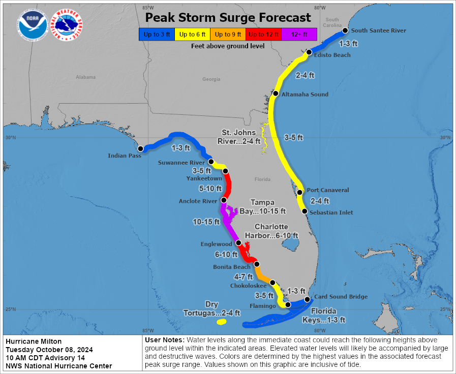
While damaging winds, flooding rains, and a risk for tornadoes will extend far away from the center of the storm and affect most of Florida, the precise track of the eye will make all the difference where the very worst storm surge occurs.
A track over or just north of Tampa Bay would expose the region to a storm surge not seen in living memory. A track just south would push the worst surge toward Charlotte Harbor and the Caloosahatchee River. It’s a matter of a few miles in either direction.
Please heed evacuation orders if you’re told to go. Time is running out. 


Follow me on Facebook | Bluesky |
Threads | Instagram | Twitter

Get in touch! Send me an email.

Please consider subscribing to my Patreon. Your support helps me write engaging, hype-free weather coverage—no fretting over ad revenue, no chasing viral clicks. Just the weather.


Author

Dennis Mersereau

I have 15+ of experience providing hype-free weather information for folks across the United States and around the world. In addition to DAMWeather, I also contribute to The Weather Network as a digital writer and weather specialist.

Follow Me
Other Articles
Previous

Milton, a now-historic Category 5 hurricane, poses grave danger to Florida

Next

New York City may soon set the record for its longest dry streak in 155 years


Local ◈ UTC
Facebook | Bluesky
Instagram | Threads | Email
DAMWeather is now ad-free! Everyone benefits from engaging, hype-free weather coverage. Please consider supporting my efforts through Patreon:


Order The Skies Above today!

Bookshop.org || Barnes & Noble
Mountaineers Books || Amazon

My latest book, The Skies Above, is now available!

Did you know a puffy cloud can weigh millions of pounds? Or that every rainbow you see is unique to you?

Our atmosphere is full of spectacular sights that are always within your reach. Glistening layers of fog, gorgeous sunsets, and brilliant meteors flashing through the sky can light up even the calmest day.

The Skies Above, published by Mountaineers Books, is a celebration of what we overlook when we look up. I was thrilled to work with the editors and illustrators at Indelible Editions to share with you the quotidian beauty of our sky.

Order your copy now and learn about the wonders we take for granted every day.

I teamed up with the editors of Outdoor Life magazine to write The Extreme Weather Survival Manual, your guide to surviving and thriving in almost any weather condition. Whether you're an avid outdoorsperson or you enjoy watching the radar from the comfort of your home, you're sure to find helpful tips, advice, and new bits of knowledge in this fascinating book.

You can buy my book today through Amazon.
  • 2026 (34)
  • 2025 (49)
  • 2024 (59)
  • 2023 (43)
  • 2022 (57)
  • 2021 (71)
  • 2020 (83)
  • 2019 (88)
  • 2018 (92)
  • 2017 (1)
  • 2016 (4)
  • 2015 (10)

Copyright 2026 — DAMWeather. All rights reserved. Blogsy WordPress Theme