Disruptive winter storm likely for the Mid-Atlantic early this week


A disruptive winter storm will sweep through the Mid-Atlantic early this week, likely bringing a hefty blanket of snow to the D.C.-Baltimore metropolitan areas. Any snow in this part of the country causes major hiccups, but up to half a foot of snow will easily shut down the region for at least a day or two.
We’re about to go a while without seeing much sunshine across much of the southeastern and Mid-Atlantic states. A strong jet stream lingering over the area won’t move much over the next week, allowing an active storm track to spawn and drag one system after another across the region.
Just take a look at how much precipitation is in the forecast over the next seven days:

A low-pressure system will develop over the lower Mississippi Valley overnight Monday into early Tuesday morning, quickly pushing a slug of precipitation toward the Mid-Atlantic. Plenty of cold air at the surface will allow precipitation to fall as snow for much of the area.
Snow will spread into northern Virginia, D.C., and Maryland on Tuesday afternoon, increasing in coverage and intensity through the evening hours. Expect snow to continue into Wednesday morning before tapering off west to east.
A few inches of snow could fall from southern Virginia all the way to central Pennsylvania, including the Philly metro area. But the bulk of the wintry weather is expected around D.C. and Baltimore.
The latest National Weather Service forecast shows a widespread blanket of 4-6 inches of snow from the Appalachians east to Delaware and southern New Jersey. A localized stripe of 6-8 inches of snow is possible along the ridgetops, as well as some of the D.C. suburbs from Culpeper east into Prince William County.
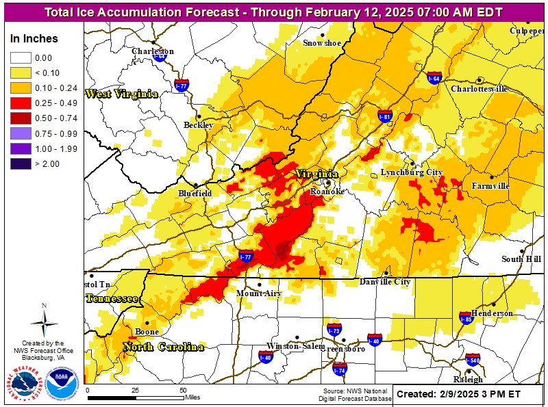
Communities in southwestern Virginia and northwestern North Carolina could see significant ice accretion from freezing rain as warm air aloft noses into the region. The latest NWS forecast shows more than one-quarter of an inch of ice building up across some of the higher elevations here. That’s enough to break weaker tree branches and possibly lead to spotty power outages.
Another disturbance will follow immediately behind this winter storm, arriving late Wednesday and lingering into Thursday. Warmer air pushing in from the south could allow for some freezing rain to fall over some of the areas expecting snow from the first system, but everyone should eventually change over to plain rain by Thursday morning.
We’ll have to watch yet another robust low-pressure system this weekend for potential winter weather impacts across the Northeast.
NOTE: The forecasts referenced in this article were issued by the National Weather Service, a critical federal agency that’s likely responsible for directly saving more lives than just about any other office in the government. The National Weather Service costs $3 per year per taxpayer.
Free and instant lifesaving warnings, Doppler radar data, satellite imagery, computer models, and realtime observations would likely vanish if this agency were gutted. Please contact your representatives to urge lawmakers to save NOAA and the National Weather Service from irreparable damage.

Follow me on Facebook | Bluesky | Instagram
Get in touch! Send me an email.
Please consider subscribing to my Patreon. Your support helps me write engaging, hype-free weather coverage—no fretting over ad revenue, no chasing viral clicks. Just the weather.