Skip to content
DAMWeather DAMWeather DAMWeather

The weather can get scary. Reporting on it doesn't have to be.

DAMWeather DAMWeather DAMWeather

The weather can get scary. Reporting on it doesn't have to be.

  • About Me
  • All Bylines
    • Books, Bylines, and Press
    • The Skies Above (Book)
    • Extreme Weather (Book)
    • The Weather Network
    • The Vane
    • Forbes
    • Capital Weather Gang
    • Mental Floss
  • Maps
    • Hurricane Maps
    • Hurricane Names
    • Monthly Tornadoes
    • Tornado Tracks
    • F5/EF-5 Tornadoes
    • SPC High Risk Days
  • GIS Resources
  • Contact Me
    • Bluesky
    • Facebook
    • Instagram
  • wxdam.com
  • About Me
  • All Bylines
    • Books, Bylines, and Press
    • The Skies Above (Book)
    • Extreme Weather (Book)
    • The Weather Network
    • The Vane
    • Forbes
    • Capital Weather Gang
    • Mental Floss
  • Maps
    • Hurricane Maps
    • Hurricane Names
    • Monthly Tornadoes
    • Tornado Tracks
    • F5/EF-5 Tornadoes
    • SPC High Risk Days
  • GIS Resources
  • Contact Me
    • Bluesky
    • Facebook
    • Instagram
  • wxdam.com
Close

Search

Checking in on the strange 2025 Atlantic hurricane season

By Dennis Mersereau
October 12, 2025 3 Min Read

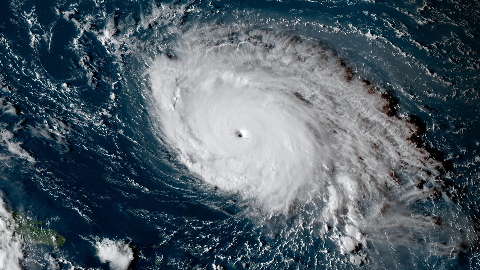
We’re more than halfway done with this year’s Atlantic hurricane season and…well, it’s been a weird one so far.
The ocean basin has produced 11 named storms through Oct. 12. This year’s storms have pretty neatly fallen into two groups so far—they’ve either struggled mightily, or absolutely reached for the stars. 
Out of those 11 named storms, four grew into hurricanes. Erin and Humberto reached category five intensity, Gabrielle was a solid category four, and Imelda reached category two strength.
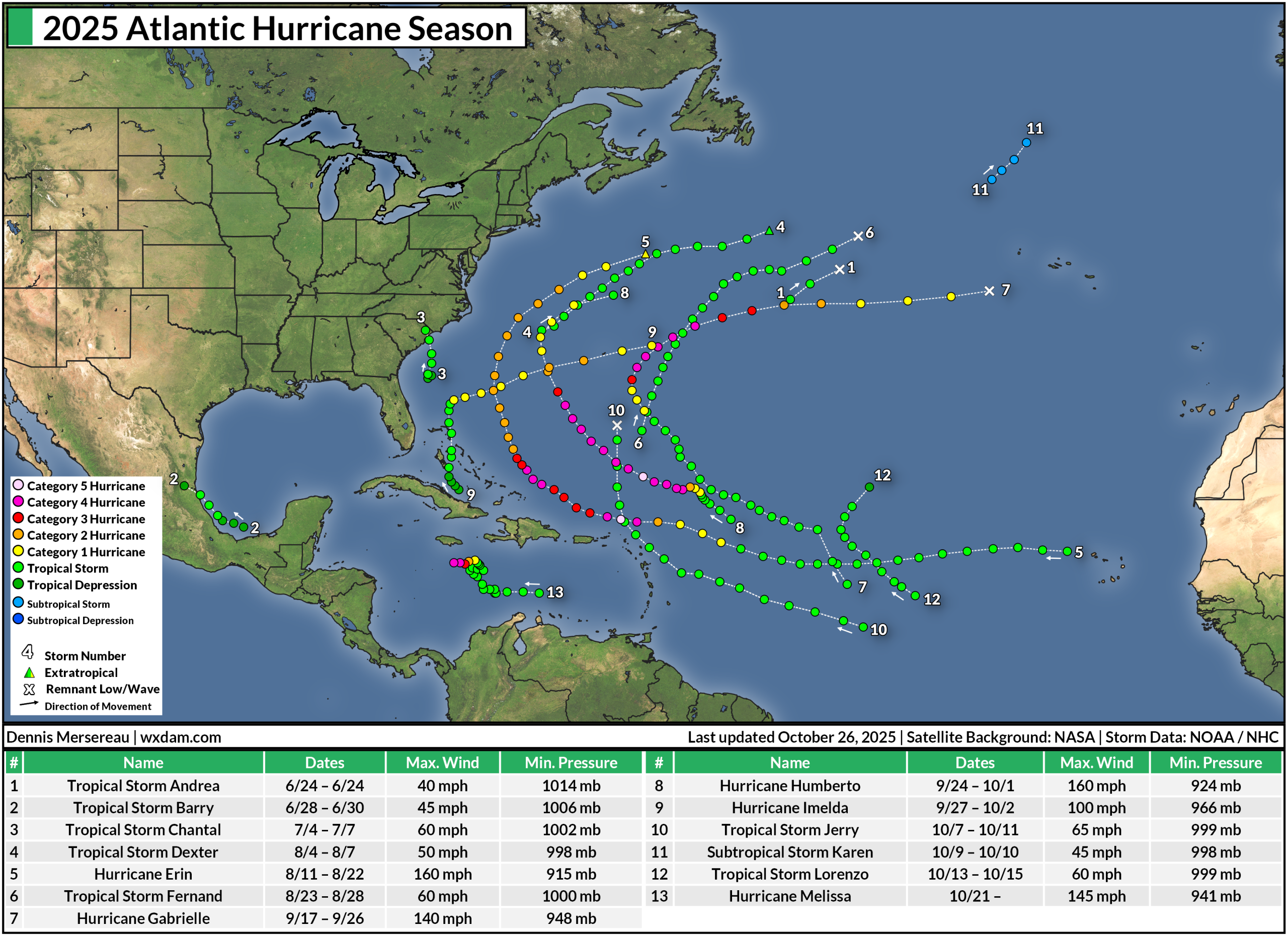
A favorable atmospheric setup has kept all but one of those storms away from the continental United States. Tropical Storm Chantal made landfall in South Carolina with 60 mph winds during the overnight hours on Sunday, July 6. Otherwise, nine out of the ten remaining storms recurved out into the open Atlantic.
We haven’t even seen any tropical systems in the Caribbean by this point in the season, a testament to the strength and placement of ridges of high pressure over the central Atlantic. If these ridges were stronger or farther west, the waves that grew into storms like Erin and Humberto may have travelled farther south into the Caribbean instead.
How does this season stack up compared to normal?

An average Atlantic hurricane season produced 14 named storms, seven hurricanes, and three major hurricanes. We’re pretty much on track to see a near-normal season, assuming we see another storm or two over the next couple of weeks. 
Even this year’s Accumulated Cyclone Energy (ACE) is near normal. ACE is a metric meteorologists use to gauge the true intensity of a hurricane season, accounting for the strength and longevity of a season’s storms. A stronger storm that lasts longer will produce higher ACE values than a weak, short-lived system.
So far this season, we’ve seen an ACE value of 96.2, which was 92.4% of normal for Oct. 11. Erin, Humberto, and Gabrielle account for more than 80% of that energy, which really throws it back to how every storm this season has either struggled or excelled.
The season isn’t over yet. Hurricane season runs through Nov. 30, and we’ve seen plenty of high-end storms form through the end of October and into November. We’ll have to start looking closer to home—in the Caribbean and Gulf of Mexico—for storm formation as we enter these final weeks of the season. 


Follow me on Facebook | Bluesky | Instagram

Get in touch! Send me an email.

Please consider subscribing to my Patreon. Your support helps me write engaging, hype-free weather coverage—no fretting over ad revenue, no chasing viral clicks. Just the weather.

  

Author

Dennis Mersereau

I have 15+ of experience providing hype-free weather information for folks across the United States and around the world. In addition to DAMWeather, I also contribute to The Weather Network as a digital writer and weather specialist.

Follow Me
Other Articles
Previous

Coastal flooding likely as blustery storm meanders off the East Coast

Next

Tropical Storm Melissa may threaten the Greater Antilles as a hurricane


Local ◈ UTC
Facebook | Bluesky
Instagram | Threads | Email
DAMWeather is now ad-free! Everyone benefits from engaging, hype-free weather coverage. Please consider supporting my efforts through Patreon:


Order The Skies Above today!

Bookshop.org || Barnes & Noble
Mountaineers Books || Amazon

My latest book, The Skies Above, is now available!

Did you know a puffy cloud can weigh millions of pounds? Or that every rainbow you see is unique to you?

Our atmosphere is full of spectacular sights that are always within your reach. Glistening layers of fog, gorgeous sunsets, and brilliant meteors flashing through the sky can light up even the calmest day.

The Skies Above, published by Mountaineers Books, is a celebration of what we overlook when we look up. I was thrilled to work with the editors and illustrators at Indelible Editions to share with you the quotidian beauty of our sky.

Order your copy now and learn about the wonders we take for granted every day.

I teamed up with the editors of Outdoor Life magazine to write The Extreme Weather Survival Manual, your guide to surviving and thriving in almost any weather condition. Whether you're an avid outdoorsperson or you enjoy watching the radar from the comfort of your home, you're sure to find helpful tips, advice, and new bits of knowledge in this fascinating book.

You can buy my book today through Amazon.
  • 2026 (34)
  • 2025 (49)
  • 2024 (59)
  • 2023 (43)
  • 2022 (57)
  • 2021 (71)
  • 2020 (83)
  • 2019 (88)
  • 2018 (92)
  • 2017 (1)
  • 2016 (4)
  • 2015 (10)

Copyright 2026 — DAMWeather. All rights reserved. Blogsy WordPress Theme