Skip to content
DAMWeather DAMWeather

The weather can get scary. Reporting on it doesn't have to be.

DAMWeather DAMWeather

The weather can get scary. Reporting on it doesn't have to be.

  • About Me
  • All Bylines
    • Books, Bylines, and Press
    • The Skies Above (Book)
    • Extreme Weather (Book)
    • The Weather Network
    • The Vane
    • Forbes
    • Capital Weather Gang
    • Mental Floss
  • Maps
    • Hurricane Maps
    • Hurricane Names
    • Monthly Tornadoes
    • Tornado Tracks
    • F5/EF-5 Tornadoes
    • SPC High Risk Days
  • GIS Resources
  • Contact Me
    • Bluesky
    • Facebook
    • Instagram
  • wxdam.com
  • About Me
  • All Bylines
    • Books, Bylines, and Press
    • The Skies Above (Book)
    • Extreme Weather (Book)
    • The Weather Network
    • The Vane
    • Forbes
    • Capital Weather Gang
    • Mental Floss
  • Maps
    • Hurricane Maps
    • Hurricane Names
    • Monthly Tornadoes
    • Tornado Tracks
    • F5/EF-5 Tornadoes
    • SPC High Risk Days
  • GIS Resources
  • Contact Me
    • Bluesky
    • Facebook
    • Instagram
  • wxdam.com
Close

Search

DAMWeather DAMWeather

The weather can get scary. Reporting on it doesn't have to be.

DAMWeather DAMWeather

The weather can get scary. Reporting on it doesn't have to be.

  • About Me
  • All Bylines
    • Books, Bylines, and Press
    • The Skies Above (Book)
    • Extreme Weather (Book)
    • The Weather Network
    • The Vane
    • Forbes
    • Capital Weather Gang
    • Mental Floss
  • Maps
    • Hurricane Maps
    • Hurricane Names
    • Monthly Tornadoes
    • Tornado Tracks
    • F5/EF-5 Tornadoes
    • SPC High Risk Days
  • GIS Resources
  • Contact Me
    • Bluesky
    • Facebook
    • Instagram
  • wxdam.com
  • About Me
  • All Bylines
    • Books, Bylines, and Press
    • The Skies Above (Book)
    • Extreme Weather (Book)
    • The Weather Network
    • The Vane
    • Forbes
    • Capital Weather Gang
    • Mental Floss
  • Maps
    • Hurricane Maps
    • Hurricane Names
    • Monthly Tornadoes
    • Tornado Tracks
    • F5/EF-5 Tornadoes
    • SPC High Risk Days
  • GIS Resources
  • Contact Me
    • Bluesky
    • Facebook
    • Instagram
  • wxdam.com
Close

Search

Hostile Atlantic Ocean Eagerly Waiting to Tear New Tropical Depression to Shreds

By Dennis Mersereau
July 5, 2018 3 Min Read

Newly-minted Tropical Depression Two is a visually impressive but ultimately doomed cyclone that’s far out in the Atlantic Ocean between the Lesser Antilles and Africa. The system in any other year would become a serious concern for interests near the coast, but in this year, this hostile year for the Atlantic Ocean and us all, the storm will last about one-third of a Scaramucci, meeting its untimely fate this Sunday in a swift and meteorologically gruesome fashion.

The National Hurricane Center’s first forecast discussion for T.D. Two reads more like the eulogy at a living funeral rather than a dire prediction of tropical woes. The environment is not suitable for significant development. The cyclone may grow strong enough to achieve the name Tropical Storm Beryl before dissipating this weekend at the hands of cooler-than-normal waters, dry air, and strong winds.

The system initially wasn’t expected to develop into much of anything, but it started to look more impressive on satellite imagery during the day on Wednesday. This is the kind of cyclone that tries to defy the odds, but fortunately for storm-weary folks near the coasts, the environment is too hostile to allow this storm to buff itself up beyond what we think should be possible. Even a stronger, more solid storm would struggle against the obstacles ahead of T.D. Two.
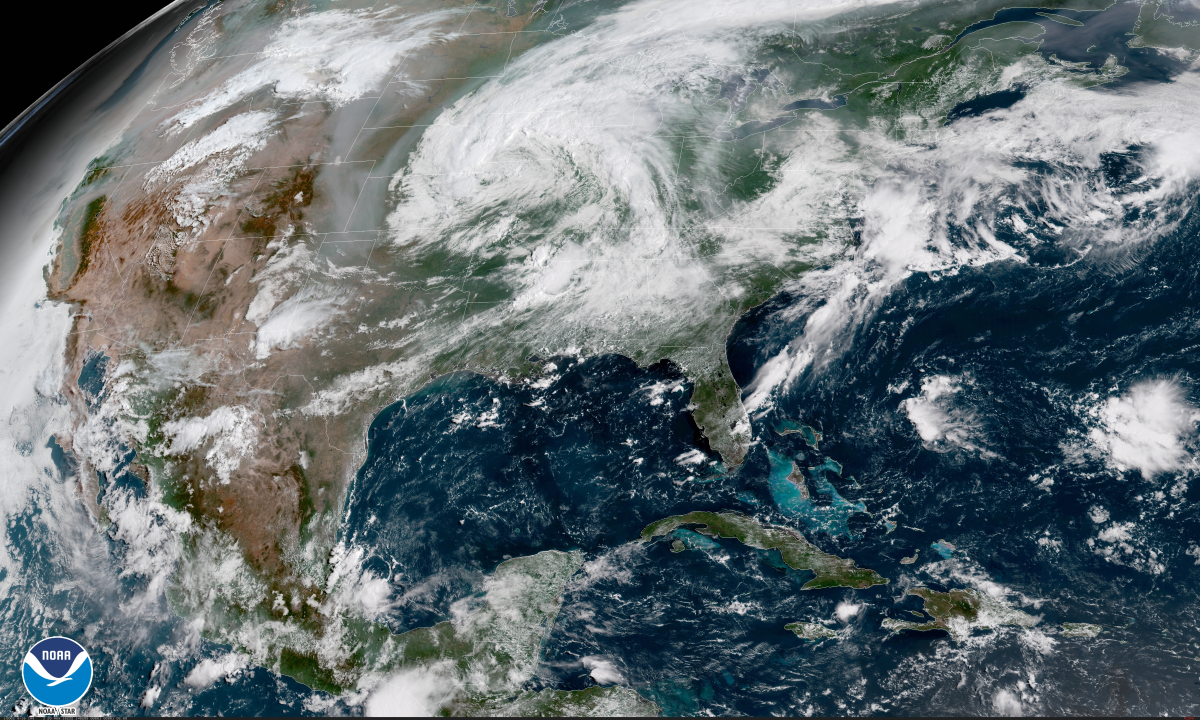
A quick look at this morning’s visible satellite image across the Atlantic shows a small, classic-looking storm that looks like it could have been the nucleus to something more ominous had it formed in a better environment. All that beige fuzz ahead of the storm over the Caribbean is Saharan dust that blew off of Africa ahead of the tropical wave that would become T.D. Two. Dusty desert air is not conducive to a juicy tropical cyclone.
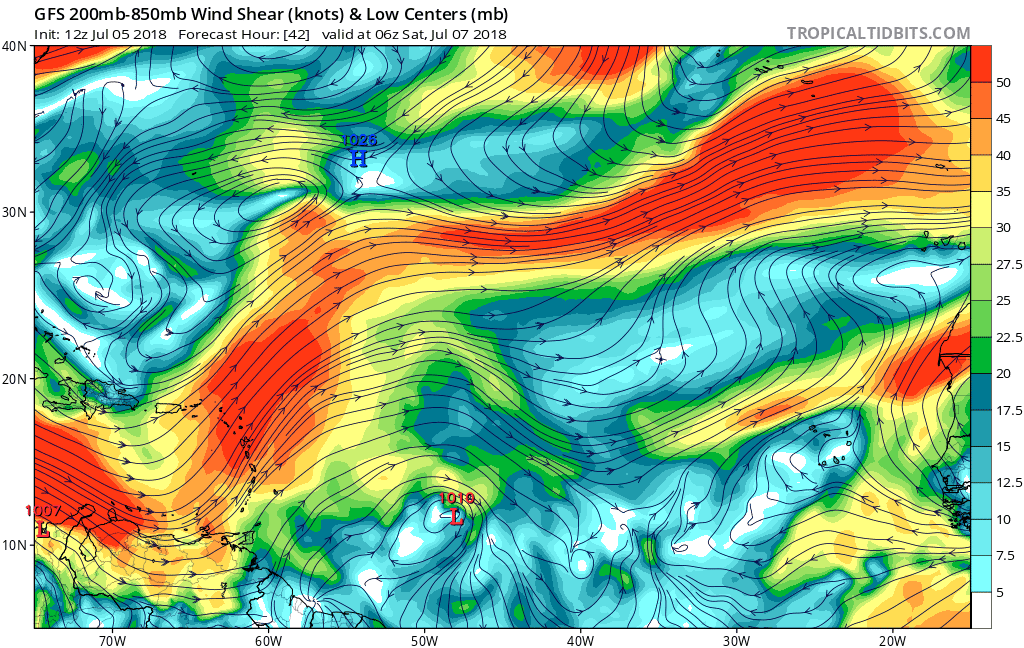
Adding insult to injury is strong wind shear over the eastern Caribbean that will shred the storm to pieces in a hurry. Strong upper-level winds disrupt the updrafts in thunderstorms that try to form and displaces existing thunderstorm activity far away from the center of the cyclone. Both of these work together to kill storms fast. It’s something special to watch the thunderstorms in a tropical cyclone floof away (technical term) so fast in dry air and strong wind shear that all that’s left is a naked low-level swirl confusedly spinning itself to oblivion.

The remnants of T.D. Two/Beryl will continue into the Antilles through early next week and bring some heavy rain to the area. Aside from a slight chance that a disturbance near Bermuda could briefly develop over the next day or so before also meeting a swift end, the Atlantic will return to its quiet state soon enough.

Related: Here’s a Hype-Free Rundown to Help You Keep Track of Storms This Hurricane Season

[Map: Dennis Mersereau | Satellite: NOAA | Model: Tropical Tidbits]


Please consider subscribing to my writing on Patreon. Reader-funded journalism is more important than ever and your support helps fund engaging, hype-free weather coverage.
Author

Dennis Mersereau

I have 15+ of experience providing hype-free weather information for folks across the United States and around the world. In addition to DAMWeather, I also contribute to The Weather Network as a digital writer and weather specialist.

Follow Me
Other Articles
Previous

Here’s Your In-Depth July 4th Weather Forecast

Next

Itty Bitty Hurricane Beryl Defies the Odds, Makes Fools of Us All


Local ◈ UTC
Facebook | Bluesky
Instagram | Threads | Email
DAMWeather is now ad-free! Everyone benefits from engaging, hype-free weather coverage. Please consider supporting my efforts through Patreon:


Order The Skies Above today!

Bookshop.org || Barnes & Noble
Mountaineers Books || Amazon

My latest book, The Skies Above, is now available!

Did you know a puffy cloud can weigh millions of pounds? Or that every rainbow you see is unique to you?

Our atmosphere is full of spectacular sights that are always within your reach. Glistening layers of fog, gorgeous sunsets, and brilliant meteors flashing through the sky can light up even the calmest day.

The Skies Above, published by Mountaineers Books, is a celebration of what we overlook when we look up. I was thrilled to work with the editors and illustrators at Indelible Editions to share with you the quotidian beauty of our sky.

Order your copy now and learn about the wonders we take for granted every day.

I teamed up with the editors of Outdoor Life magazine to write The Extreme Weather Survival Manual, your guide to surviving and thriving in almost any weather condition. Whether you're an avid outdoorsperson or you enjoy watching the radar from the comfort of your home, you're sure to find helpful tips, advice, and new bits of knowledge in this fascinating book.

You can buy my book today through Amazon.
  • 2026 (35)
  • 2025 (49)
  • 2024 (59)
  • 2023 (43)
  • 2022 (57)
  • 2021 (71)
  • 2020 (83)
  • 2019 (88)
  • 2018 (92)
  • 2017 (1)
  • 2016 (4)
  • 2015 (10)

Copyright 2026 — DAMWeather. All rights reserved. Blogsy WordPress Theme