Skip to content
DAMWeather DAMWeather

The weather can get scary. Reporting on it doesn't have to be.

DAMWeather DAMWeather

The weather can get scary. Reporting on it doesn't have to be.

  • About Me
  • All Bylines
    • Books, Bylines, and Press
    • The Skies Above (Book)
    • Extreme Weather (Book)
    • The Weather Network
    • The Vane
    • Forbes
    • Capital Weather Gang
    • Mental Floss
  • Maps
    • Hurricane Maps
    • Hurricane Names
    • Monthly Tornadoes
    • Tornado Tracks
    • F5/EF-5 Tornadoes
    • SPC High Risk Days
  • GIS Resources
  • Contact Me
    • Bluesky
    • Facebook
    • Instagram
  • wxdam.com
  • About Me
  • All Bylines
    • Books, Bylines, and Press
    • The Skies Above (Book)
    • Extreme Weather (Book)
    • The Weather Network
    • The Vane
    • Forbes
    • Capital Weather Gang
    • Mental Floss
  • Maps
    • Hurricane Maps
    • Hurricane Names
    • Monthly Tornadoes
    • Tornado Tracks
    • F5/EF-5 Tornadoes
    • SPC High Risk Days
  • GIS Resources
  • Contact Me
    • Bluesky
    • Facebook
    • Instagram
  • wxdam.com
Close

Search

DAMWeather DAMWeather

The weather can get scary. Reporting on it doesn't have to be.

DAMWeather DAMWeather

The weather can get scary. Reporting on it doesn't have to be.

  • About Me
  • All Bylines
    • Books, Bylines, and Press
    • The Skies Above (Book)
    • Extreme Weather (Book)
    • The Weather Network
    • The Vane
    • Forbes
    • Capital Weather Gang
    • Mental Floss
  • Maps
    • Hurricane Maps
    • Hurricane Names
    • Monthly Tornadoes
    • Tornado Tracks
    • F5/EF-5 Tornadoes
    • SPC High Risk Days
  • GIS Resources
  • Contact Me
    • Bluesky
    • Facebook
    • Instagram
  • wxdam.com
  • About Me
  • All Bylines
    • Books, Bylines, and Press
    • The Skies Above (Book)
    • Extreme Weather (Book)
    • The Weather Network
    • The Vane
    • Forbes
    • Capital Weather Gang
    • Mental Floss
  • Maps
    • Hurricane Maps
    • Hurricane Names
    • Monthly Tornadoes
    • Tornado Tracks
    • F5/EF-5 Tornadoes
    • SPC High Risk Days
  • GIS Resources
  • Contact Me
    • Bluesky
    • Facebook
    • Instagram
  • wxdam.com
Close

Search

Itty Bitty Hurricane Beryl Defies the Odds, Makes Fools of Us All

By Dennis Mersereau
July 6, 2018 3 Min Read

Looks sometimes aren’t deceiving at all. A tiny, good lookin’ tropical depression far out in the Atlantic Ocean suddenly and surprisingly developed into a full-fledged hurricane that’s so small you could miss it from space without knowing where to look. Hurricane Beryl unexpectedly strengthened into a category one hurricane in less than 24 hours, packing 80 MPH winds around a pinhole eye. The hurricane is about as small as one can get, barely registering larger than your average squall line.

Yesterday I wrote that this storm is “the kind of cyclone that tries to defy the odds” due to its appearance and location, but ultimately couldn’t due to its weakness and the hostile environment it’s approaching:

The system initially wasn’t expected to develop into much of anything,
but it started to look more impressive on satellite imagery during the
day on Wednesday. This is the kind of cyclone that tries to defy the
odds, but fortunately for storm-weary folks near the coasts, the
environment is too hostile to allow this storm to buff itself up beyond
what we think should be possible. Even a stronger, more solid storm
would struggle against the obstacles ahead of T.D. Two.

Oops. Talk about defying the odds.

Hurricane Beryl has maximum winds of 80 MPH this morning as it scoots west toward the Lesser Antilles. The latest forecast from the National Hurricane Center shows the storm possibly reaching the islands as a hurricane before slowly weakening once it enters the Caribbean. Beryl’s diminutive size will be its saving grace—even if the worst conditions affect land, it wouldn’t be for more than a few hours. The greatest threat with this storm would be flooding and mudslides from heavy rain.

Hurricane Beryl’s hurricane-force winds only extend 10 miles away from the center of the eye, and winds greater than 39 MPH only extend out 35 miles. My favorite size comparison for tropical cyclones (and one that always draws ire from some weather folks for its ridiculousness) is to overlay a storm’s wind field over the Washington D.C. metro area to show how relatively small it is:
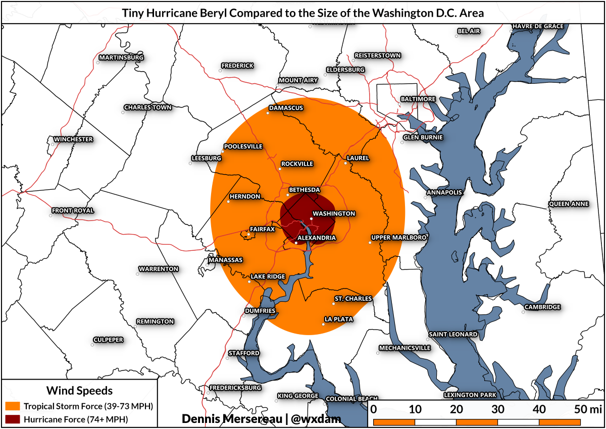
Beryl’s hurricane-force wind field is so small that it just barely covers Washington D.C. with just enough room to fit in most of Arlington County, Virginia. The storm’s field of 39+ MPH winds would be big enough to stretch from Howard County to Charles County in Maryland.

Meteorologists and weather models have a hard time forecasting the
intensity of exceptionally small tropical cyclones; this storm’s core
isn’t much bigger than a healthy supercell. Beryl is tiny, and tiny
storms have a history of wildly fluctuating in intensity. On paper, at
least, it seems like the storm shouldn’t have achieved its current
strength. But Beryl is small enough that it found itself a pocket of
favorable-enough conditions and took full advantage of what it found.

The
storm’s structure should insulate it just enough from wind shear and
dry air that it could survive into the Caribbean before starting to
weaken and fall apart. However, the NHC notes in its latest forecast
that predictions are more uncertain than usual because of the
hurricane’s tiny size. Tiny storms are fragile. Beryl brings to mind
Hurricane Danny from 2015, a similarly tiny storm in roughly the same
spot that reached major hurricane strength before collapsing as it
approached the Lesser Antilles.

Storms like this are humbling for meteorologists and weather enthusiasts alike. I was wrong. They were wrong. We were all wrong. (Crow all around!) Nobody initially expected this storm to strengthen the way it did and they’re probably lying to make themselves look good if they tell you otherwise. Predicting the weather is still an inexact science and there’s a lot for even the experts to learn about how and why tropical cyclones suddenly intensify, especially itty bitty ones like Beryl.

[Satellite: NOAA | Maps: me]


Please consider subscribing to my writing on Patreon. Reader-funded journalism is more important than ever and your support helps fund engaging, hype-free weather coverage.
Author

Dennis Mersereau

I have 15+ of experience providing hype-free weather information for folks across the United States and around the world. In addition to DAMWeather, I also contribute to The Weather Network as a digital writer and weather specialist.

Follow Me
Other Articles
Previous

Hostile Atlantic Ocean Eagerly Waiting to Tear New Tropical Depression to Shreds

Next

Intense Southern California Heat Wave Shatters All-Time Record Highs


Local ◈ UTC
Facebook | Bluesky
Instagram | Threads | Email
DAMWeather is now ad-free! Everyone benefits from engaging, hype-free weather coverage. Please consider supporting my efforts through Patreon:


Order The Skies Above today!

Bookshop.org || Barnes & Noble
Mountaineers Books || Amazon

My latest book, The Skies Above, is now available!

Did you know a puffy cloud can weigh millions of pounds? Or that every rainbow you see is unique to you?

Our atmosphere is full of spectacular sights that are always within your reach. Glistening layers of fog, gorgeous sunsets, and brilliant meteors flashing through the sky can light up even the calmest day.

The Skies Above, published by Mountaineers Books, is a celebration of what we overlook when we look up. I was thrilled to work with the editors and illustrators at Indelible Editions to share with you the quotidian beauty of our sky.

Order your copy now and learn about the wonders we take for granted every day.

I teamed up with the editors of Outdoor Life magazine to write The Extreme Weather Survival Manual, your guide to surviving and thriving in almost any weather condition. Whether you're an avid outdoorsperson or you enjoy watching the radar from the comfort of your home, you're sure to find helpful tips, advice, and new bits of knowledge in this fascinating book.

You can buy my book today through Amazon.
  • 2026 (35)
  • 2025 (49)
  • 2024 (59)
  • 2023 (43)
  • 2022 (57)
  • 2021 (71)
  • 2020 (83)
  • 2019 (88)
  • 2018 (92)
  • 2017 (1)
  • 2016 (4)
  • 2015 (10)

Copyright 2026 — DAMWeather. All rights reserved. Blogsy WordPress Theme