The Stalled Tropical Storm Off the East Coast Cooled the Gulf Stream Beneath It

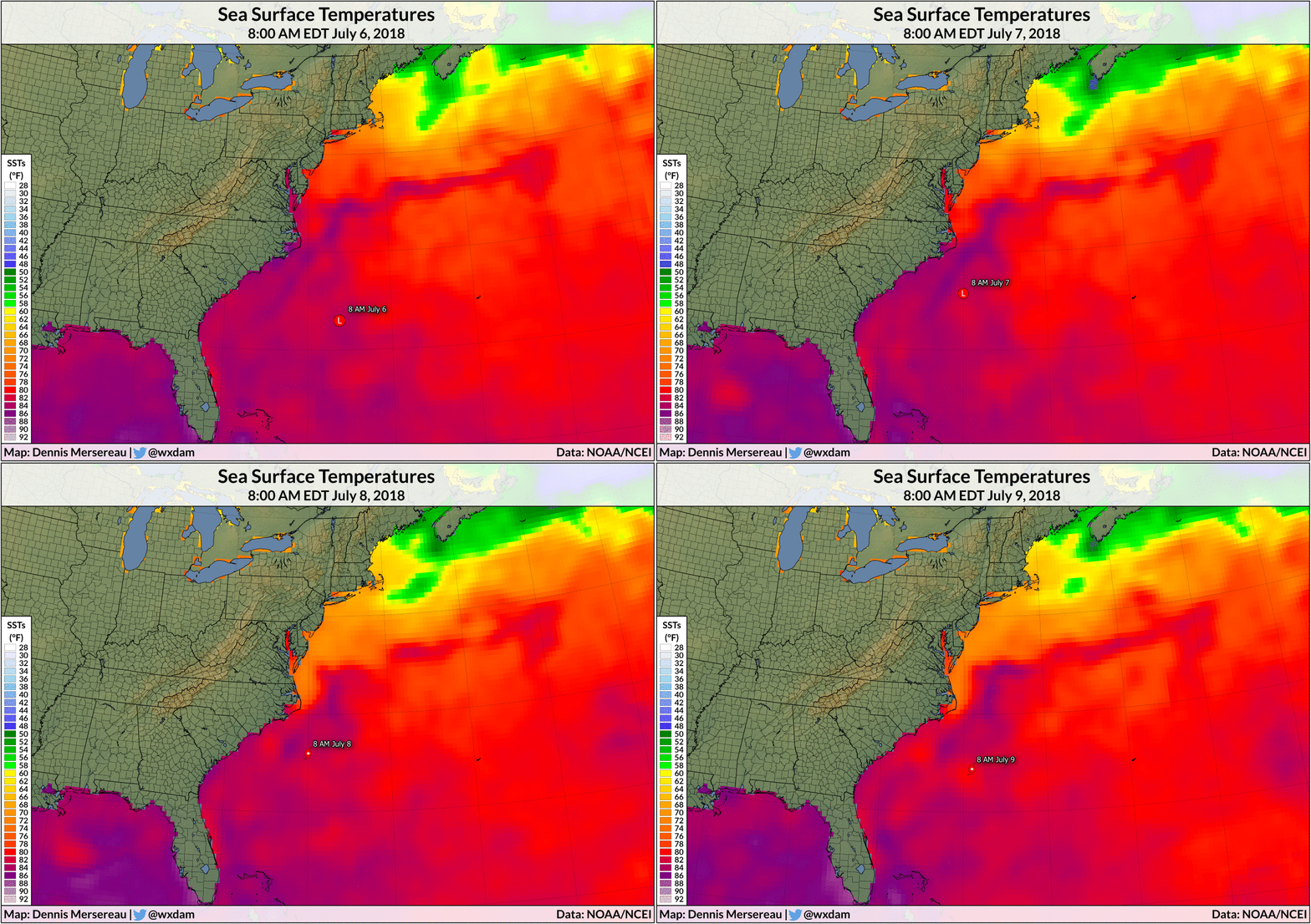
Tropical Storm Chris is very close to hurricane strength this afternoon as it finally starts to move northeast a few hundred miles off the North Carolina coast. The storm has barely moved since it formed five days ago, caught between weather systems without any steering currents to shove it along. The storm’s stalled motion has induced upwelling in the ocean beneath it, which worked in part to keep the storm from strengthening too quickly.
Chris is one of those storms that gives coastal residents some uneasy relief. The storm is pretty darn close to the United States, and it’s never comforting to see a storm approaching hurricane strength right off the eastern seaboard. Chris is pinned between ridges of high pressure to its north, west, and east—the storm got trapped by the same features keeping it from hitting the United States, and there hasn’t been anything to steer it away until the ridge holding it in place broke today and a trough lifts the storm out to sea.

The tropical storm sitting over roughly the same spot in the Atlantic Ocean for five days has considerably churned the seawater beneath it. This churning has allowed for upwelling, or cooler water from deep in the ocean to rise to the surface. A buoy near the storm has recorded a precipitous drop in water temperatures over the past couple of days. The buoy measured water temperatures around 82°F on Saturday, July 7, before falling as Chris grew stronger. The buoy’s latest measurement recorded waters below 76°F, a six-degree drop in just a couple of days. That’s even more impressive when you consider that the buoy is in the Gulf Stream.
The pool of cooler water is readily apparent in daily sea surface temperature analyses. The animation at the top of this post shows the sudden drop in sea surface temperatures beneath the tropical storm between the mornings of July 6 and July 9. Today’s analysis, likely showing even cooler waters in spots, will be released tomorrow morning.

The cooler water clearly had an effect on Chris when it started to struggle a bit with its organization on Monday. The combination of dry air wrapping into the storm and cooler water beneath it served to disrupt the tropical storm’s structure on Monday. The storm is much better organized today after it mixed out and walled off the dry air and it’s starting to lift northeast away from the pool of cooler water it churned up. The storm’s look (above) matches its strength now, with a tight core and a clearing eye.
Tropical cyclones strengthen through latent heat release. Warm water on the surface of the ocean evaporates and condenses in the storm, releasing latent heat that provides the instability necessary to sustain thunderstorms around the core of the cyclone. The warmer the water, the greater the latent heat release, and the stronger a storm can get. Cool waters inhibit this process and eventually choke off a storm by weakening the thunderstorms that surround the center of circulation.
The National Hurricane Center expects Chris to reach hurricane strength later today as it accelerates toward the northeast. While the storm will remain far offshore, dangerous rip currents and
rough surf are still likely along the East Coast for the next
day or two as Chris finally exits the area. The storm’s peak strength won’t last long—Chris will reach cooler water and less favorable conditions on Thursday, weakening the storm and forcing it to transition into an extratropical cyclone. The latest forecast shows Chris or its remnants clipping southeastern Newfoundland early Friday morning, likely bringing some heavy rain and gusty winds to the provincial capital of St. John’s.
[Chart: NOAA | Maps: me | Satellite data courtesy of AllisonHouse]
Please consider subscribing to my Patreon. Reader-funded news is more important than ever and your support helps fund engaging, hype-free weather coverage.