Another Weak Storm Forms in Oceanic Boondocks As Peak of Hurricane Season Nears

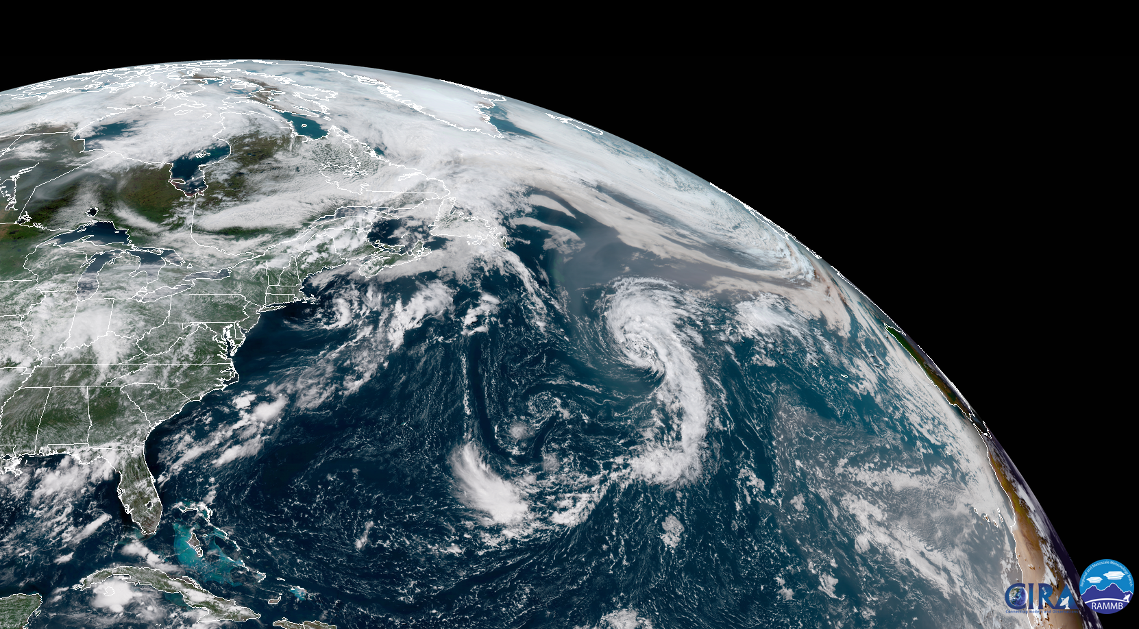
Subtropical Storm Ernesto formed in the northern Atlantic Ocean on Wednesday, posing a threat to nothing but some fish and ships. The cyclone may strengthen a tiny bit over the next day or two as it accelerates northeast toward a less favorable environment. The Atlantic hurricane season has been rather anemic this year, puffing out storms that look more like Ernesto than anything more serious. (Not that there’s anything wrong with that.) But don’t let the quietness fool you—we’re on the doorstep of peak season, and history says there’s a good chance we’ll see a decent storm or two in the next few weeks.
The National Hurricane Center says that Subtropical Storm Ernesto has 40 MPH winds as it lingers many hundreds of miles from anyone who cares. The system is…sufficiently spinny?…on satellite imagery. It’s hard to find anything complimentary to say about a sad storm like this. One interesting sight is that you can actually see smoke from the California wildfires wrapping into the storm from the north. (Yes, really.) The storm will continue in the general direction of the Ireland and the United Kingdom as it degenerates and merges into a frontal system this weekend.
Ernesto is a subtropical storm. The difference between subtropical and tropical is an academic exercise that does more to confuse people than serve a practical purpose. A tropical cyclone is a low-pressure system that has a tightly-packed core of thunderstorms around its center of circulation. A tropical cyclone has warm air through the entire storm—top to bottom, side to side—and the storm gathers its energy through the thunderstorms at the core of the storm.
A subtropical cyclone, on the other hand, is one that features characteristics of both a tropical cyclone and an extratropical cyclone, or the typical low-pressure system you’d see over land. A subtropical cyclone isn’t uniformly warm throughout the entire storm. A subtropical cyclone’s thunderstorms and winds can be far removed from the center of circulation. A subtropical cyclone usually gathers some of its energy from upper-level winds rather than through thunderstorm activity.
Subtropical cyclones are kind of tropical, and their impacts are similar enough to tropical systems that the NHC gives them the same treatment.
So far this year, four out of the five storms we’ve seen in the Atlantic Ocean were subtropical at one point during their life cycles. It’s a testament to the unfavorable conditions that have dominated the ocean basin for the past couple of months.
The end of May saw Alberto make landfall in Florida as a subtropical storm. The unlikely life of Hurricane Beryl swiftly ended as it approached the Lesser Antilles, only to redevelop as a subtropical storm almost a week later. And Debby formed in roughly the same spot as today’s Ernesto, starting life as a subtropical storm before transitioning into a fully-tropical storm with 50 MPH winds.
We’ll have to keep a very close eye on the tropics over the next month. While unfavorable conditions for tropical development—high wind shear, dry air, Saharan dust—will continue for the foreseeable future, we’re in prime season for tropical waves coming off of Africa’s west coast to develop into something more. The NHC’s evening forecast on Wednesday called for a small window of opportunity for a bulky tropical wave moving toward the Lesser Antilles to develop a bit before wind shear gets a hold of it.
The most dangerous threat we face in a quiet hurricane season is complacency. There are plenty of examples of slow years pumping out a major storm. The slow 1997 hurricane season produced Hurricane Danny, a destructive storm on the Gulf Coast that caused nine-figure damages and dropped more than three feet of rain on Dauphin Island, Alabama. The posterchild for “don’t let a quiet season fool you” is Hurricane Andrew, forming in the middle of August during the otherwise-quiet 1992 hurricane season.
[Satellite Image: RAMMB/CIRA]
Please consider subscribing to my Patreon. Reader-funded news is more important than ever and your support helps fund engaging, hype-free weather coverage.