Skip to content
DAMWeather DAMWeather DAMWeather

The weather can get scary. Reporting on it doesn't have to be.

DAMWeather DAMWeather DAMWeather

The weather can get scary. Reporting on it doesn't have to be.

  • About Me
  • All Bylines
    • Books, Bylines, and Press
    • The Skies Above (Book)
    • Extreme Weather (Book)
    • The Weather Network
    • The Vane
    • Forbes
    • Capital Weather Gang
    • Mental Floss
  • Maps
    • Hurricane Maps
    • Hurricane Names
    • Monthly Tornadoes
    • Tornado Tracks
    • F5/EF-5 Tornadoes
    • SPC High Risk Days
  • GIS Resources
  • Contact Me
    • Bluesky
    • Facebook
    • Instagram
  • wxdam.com
  • About Me
  • All Bylines
    • Books, Bylines, and Press
    • The Skies Above (Book)
    • Extreme Weather (Book)
    • The Weather Network
    • The Vane
    • Forbes
    • Capital Weather Gang
    • Mental Floss
  • Maps
    • Hurricane Maps
    • Hurricane Names
    • Monthly Tornadoes
    • Tornado Tracks
    • F5/EF-5 Tornadoes
    • SPC High Risk Days
  • GIS Resources
  • Contact Me
    • Bluesky
    • Facebook
    • Instagram
  • wxdam.com
Close

Search

Hurricane Lane May Pose a Threat to the Hawaiian Islands Later This Week

By Dennis Mersereau
August 21, 2018 3 Min Read

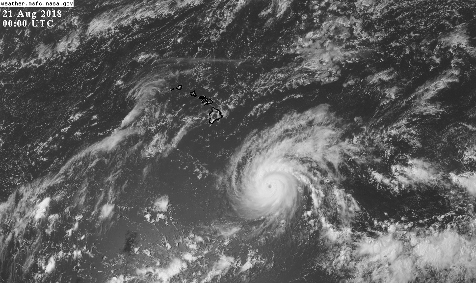
Hurricane Lane is a powerful category four storm this afternoon as it slowly makes its way in the direction of Hawaii. The storm is forecast to take a path that brings it uncomfortably close to the Hawaiian Islands later this week, though exactly how close—and its impacts—are still to be determined given the complicated setup driving the hurricane’s future path.
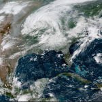
Source: NOAA/NASA

Several aircraft investigated Hurricane Lane this afternoon and found that the storm had maximum sustained winds of 130 MPH and a minimum central pressure of 964 mb. This makes Lane a category four hurricane on the Saffir-Simpson Hurricane Wind Scale, the second such storm in this part of the world in the past week. Hurricane Hector passed through the same area last week as a stronger storm. 

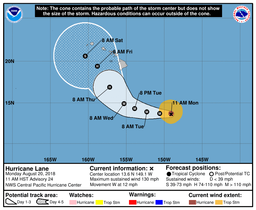
The latest forecast from the Central Pacific Hurricane Center—the NHC‘s sister agency in Honolulu—shows Lane turning toward the northwest around the middle of the week. While the storm will start to lose strength as it encounters wind shear closer to the islands, it will still be a strong storm as it comes dangerously close to the 50th state.
All seven populated islands are within the cone of uncertainty, which is the historical margin of error in previous hurricane track forecasts. The cone of uncertainty only applies to the eye of the storm, however, and Hurricane Lane’s effects will extend hundreds of miles from the center of the storm. Even if the storm’s eye misses Hawaii to the south, significant impacts can’t be ruled out, especially on the Big Island, Maui, Lanai, and Molokai.

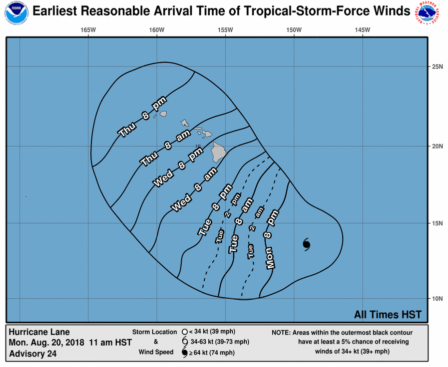
On the storm’s current path and timing, watches and warnings will likely be required for the Big Island within the next day. The latest CPHC forecast says that Wednesday morning is the earliest reasonable arrival time for tropical storm force winds if they affect the Big Island, with the successive islands feeling the first effects over the following day.

Lane is in an environment that makes it hard for forecasters and weather models to agree on what will happen. The storm’s future path will be determined by the strength of two ridges of high pressure—one to the southeast of the hurricane and one to the east. The interplay between the two ridges will dictate how soon and how sharply Lane curves north/northwest as it approaches the islands.

Just like their counterparts at the National Hurricane center, the Central Pacific Hurricane Center in Honolulu will issue updates on Hurricane Lane every six hours—at 11 and 5 AM/PM—with intermediate updates every three hours in between once watches and warnings are in effect. Hawaii is six hours behind Eastern Daylight Time.


You can follow me on Twitter or send me an email.

Please consider subscribing to my Patreon. Reader-funded news is more important than ever and your support helps fund engaging, hype-free weather coverage.
 

Author

Dennis Mersereau

I have 15+ of experience providing hype-free weather information for folks across the United States and around the world. In addition to DAMWeather, I also contribute to The Weather Network as a digital writer and weather specialist.

Follow Me
Other Articles
Previous

Benevolent Low-Pressure System Set to Bring Sweet, Merciful Taste of Fall

Next

Hurricane Lane May Pose a Threat to the Hawaiian Islands Later This Week


Local ◈ UTC
Facebook | Bluesky
Instagram | Threads | Email
DAMWeather is now ad-free! Everyone benefits from engaging, hype-free weather coverage. Please consider supporting my efforts through Patreon:


Order The Skies Above today!

Bookshop.org || Barnes & Noble
Mountaineers Books || Amazon

My latest book, The Skies Above, is now available!

Did you know a puffy cloud can weigh millions of pounds? Or that every rainbow you see is unique to you?

Our atmosphere is full of spectacular sights that are always within your reach. Glistening layers of fog, gorgeous sunsets, and brilliant meteors flashing through the sky can light up even the calmest day.

The Skies Above, published by Mountaineers Books, is a celebration of what we overlook when we look up. I was thrilled to work with the editors and illustrators at Indelible Editions to share with you the quotidian beauty of our sky.

Order your copy now and learn about the wonders we take for granted every day.

I teamed up with the editors of Outdoor Life magazine to write The Extreme Weather Survival Manual, your guide to surviving and thriving in almost any weather condition. Whether you're an avid outdoorsperson or you enjoy watching the radar from the comfort of your home, you're sure to find helpful tips, advice, and new bits of knowledge in this fascinating book.

You can buy my book today through Amazon.
  • 2026 (34)
  • 2025 (49)
  • 2024 (59)
  • 2023 (43)
  • 2022 (57)
  • 2021 (71)
  • 2020 (83)
  • 2019 (88)
  • 2018 (92)
  • 2017 (1)
  • 2016 (4)
  • 2015 (10)

Copyright 2026 — DAMWeather. All rights reserved. Blogsy WordPress Theme