Nighttime Severe Thunderstorms Are Possible in Mississippi and Alabama on Thursday


A risk for nighttime tornadoes—some potentially strong or long-lived—will unfold this evening and tonight across parts of southern Mississippi and Alabama. Damaging straight-line winds and large hail are also possible. Severe weather is dangerous no matter when it occurs, but it’s especially threatening at night when people aren’t paying attention or they’re asleep.
Thursday’s severe weather risk is part of a multi-day severe weather outbreak that began Wednesday on the southern Plains. The system responsible for the severe weather will lead to the development of one or more rounds of severe weather that will affect parts of Louisiana, Mississippi, and Alabama on Thursday evening and overnight into Friday.

A squall line was already underway at the time of this post’s publication. The above radar image shows what the storms looked like at 3:30 PM CDT. The line of storms moving into south-central Mississippi had a nasty bite to them, with severe thunderstorm and tornado warnings in effect for various parts of the line. All of this action will continue lumbering east through the evening and overnight hours.
The greatest threat for severe weather covers much of the northern Gulf Coast, including New Orleans, Biloxi, Gulfport, Mobile, and Pensacola. The latest forecast from the Storm Prediction Center paints an enhanced risk for severe weather across these areas. While this is the “bullseye” for dangerous weather, the threat for damaging winds, large hail, and isolated tornadoes extends much farther to the north toward Tennessee and Kentucky.

The best dynamics for severe weather seem to be setting up over southern Mississippi and Alabama, as well as the western Florida Panhandle. The SPC placed the areas under a 10% risk for tornadoes—a number that seems small, but is relatively large when it comes to tornadoes. The black hatching indicates the area where the atmosphere could support strong, long-lived tornadoes.
Tornadoes are most likely in discrete thunderstorms that develop out ahead of the main squall line, though tornadoes are also possible embedded in the storms within the squall line. Embedded tornadoes can happen very quickly in a situation like this, cutting down the tornado warning lead time most of us are used to.

Damaging winds can produce just as much damage as a tornado over a much wider area. The SPC seems particularly concerned about the risk for damaging wind gusts from one or more squall lines along a stretch from western Mississippi—including Jackson and the surrounding areas—through western Alabama.
Nighttime tornadoes are terrifying because people stop paying attention to severe weather once the sun goes down and lots of people don’t have a reliable way to hear warnings once they’re asleep. If you’re in the areas at risk for severe weather tonight, stay aware and get prepared for dangerous thunderstorms overnight.
You won’t see the tornado coming when it’s dark and the tornado is wrapped in rain. Tornado sirens are outdoor warning systems that are not meant to be heard indoors. Your weather app may not alert you to a tornado warning in time, either, especially when the storms are moving quickly and every second counts.
Check to see that the “emergency alerts” are activated on your mobile device. The Wireless Emergency Alert System—the system they tested on the national level last year that freaked everyone out—delivers a push notification to your device direct from the National Weather Service the moment they issue a warning. The system triangulates your location based on your cell signal to determine if you’re in a tornado warning. It works. It’s saved lives.
The risk for severe weather tonight is its own advertisement for the benefits of a NOAA Weather Radio. Modern weather radios have the ability to program your county into the device so you’re alerted to watches and warnings the moment they’re issued for your county. The radio sounds a loud alarm and automatically tunes to the feed so you can hear the warning read out loud. Weather radios may feel like an antiquated technology in the smartphone era, but they’re like smoke detectors for the weather. (If you ever need help setting one up, email me!)
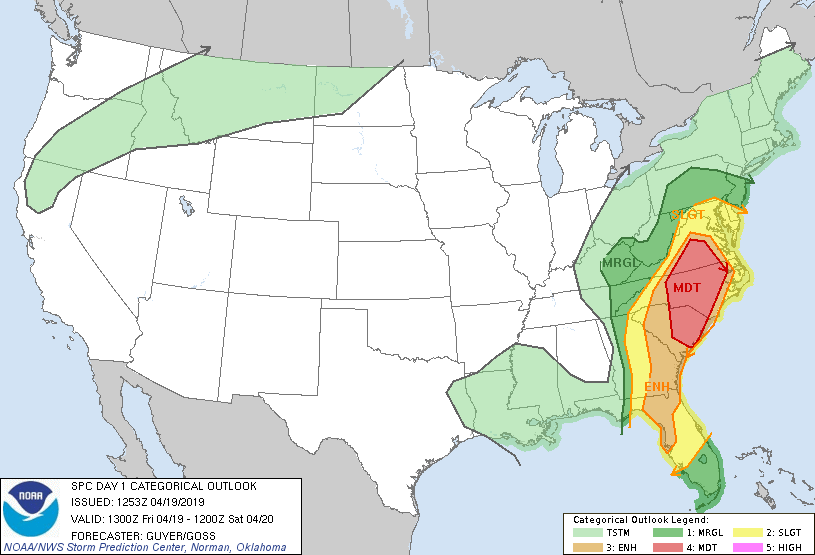
The threat for severe weather will shift east tomorrow and stretch from the Mid-Atlantic to the Florida Peninsula. I’ll have a post on that later this evening or tomorrow morning.
Please consider subscribing to my Patreon. Reader-funded news is more important than ever and your support helps fund engaging, hype-free weather coverage.