Here’s Why the Atmosphere Is Primed for a High-End Tornado Outbreak on the Plains


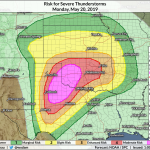
A rare high risk for severe weather is in effect Monday for a large chunk of Texas and Oklahoma, now including the Oklahoma City metro area, ahead of what could be a high-end severe weather event for the region. It’s been a long time since conditions have been this ripe for severe weather on the southern Plains. Today’s forecast—and stern warnings from meteorologists—are the weather equivalent to red lights flashing and alarm bells ringing. Here’s a quick look at why the environment is so primed for dangerous thunderstorms today.
(See my post earlier today for a detailed look at today’s threat and some safety advice.)

The high risk is in effect because of the high risk for potentially violent and long-track tornadoes—and that’s the SPC’s words, not mine. There’s a 45% risk for tornadoes across parts of Texas and Oklahoma, which is an extreme probability when you consider your daily risk of seeing a tornado, even on the Plains, is down around 0%. The tornado threat isn’t confined to the high risk. Just about everyone in Oklahoma, a large chunk of Texas, and parts of Arkansas, Missouri, and Kansas, are under an elevated threat for tornadoes today. For some perspective, we really start to get concerned when the probability for tornadoes ticks up to 10% or higher.
Here’s why this is happening today.
 |
| Modeled upper-level winds at 3:00 PM CDT Monday. (NOAA/SPC) |
A powerful jet stream—unusually powerful for this far south in late May—moving across the southern Rockies will set the stage for dangerous thunderstorms across the southern Plains on Monday. The trough generated a low-pressure system at the surface in northeastern New Mexico, which is allowing strong southerly winds to drag deeply unstable air north from the Gulf of Mexico.
 |
| Modeled surface Theta-E at 4:00 PM CDT Monday. (TwisterData) |
The above image shows “Theta-E” at the surface this afternoon, according to the latest run of the GFS weather model. Theta-E is a great way to visualize an unstable air mass in this kind of severe weather setup because it combines temperature and moisture. The reds and purples over Texas and Oklahoma show warm temperature and high moisture, which act as the fuel that powers thunderstorms.
Severe thunderstorms will develop in a hurry today in that warm sector over Texas and Oklahoma. Storms will likely start firing along the dry line, which is the sharp gradient between high moisture and low moisture located over the Texas Panhandle, and grow eastward from there through the afternoon and evening hours.
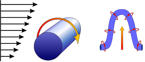 |
| A diagram of wind shear (left) and a diagram showing how a thunderstorm updraft tilts that rotation into the vertical, leading to a supercell thunderstorm (right). NOAA/NWS |
Any thunderstorm that develops has the potential to turn into a tornadic supercell in this kind of environment. A supercell is a thunderstorm with a rotating updraft. The updraft begins rotating due to strong wind shear through the atmosphere. We’ve got strong southeasterly winds near the surface and strong southwesterly winds at the upper-levels of the atmosphere. The rapid increase in wind speed and sharp change in wind direction with height creates horizontal rotation in the atmosphere. The updraft in a developing thunderstorm can push that horizontal rotation into a vertical position, which causes the updraft (and the storm itself) to begin rotating.
 |
| Modeled Significant Tornado Parameter (STP) at 3:00 PM CDT Monday. NOAA/SPC |
You can neatly summarize the threat by looking at composite indices, which take into account factors such as wind shear and instability to determine the threat for features like supercells and significant tornadoes. The above image is a model-generated image of the much-advertised “significant tornado parameter,” which shows how favorable the environment is for significant (EF-2+) tornadoes. STP values around 1 or 2 are typically cause for concern, so when we’re seeing models spit out a large field of values greater than 6 where we know dangerous thunderstorms will likely develop, the alarm bells start going off.
I mentioned in my last post that not every storm will reach its maximum potential, but there’s a really, really good chance that some storms will:
It appears the environment will be capable of supporting a high-end severe weather outbreak. It’s hard for big severe weather outbreaks to occur. Lots of things have to go right and it’s easy for storms to morph into a sloppy mess on a day like this. Even if the storms on Monday don’t reach maximum capacity—and many likely won’t!—one storm breaking through to produce one bad tornado is still a big deal.
I keep flashing on the Lee County, AL, tornado from a couple of months ago. The storms that day were largely sloppy, but one supercell broke loose and put down an EF-4. It’s cliche, sure, but it really does only take one. Please take the threat seriously and prepare even if it doesn’t turn into a classic tornado outbreak.
Even the storms that don’t produce significant tornadoes will be dangerous. This severe weather outbreak will occur in several rounds. Supercells will eventually grow and merge into large clusters and lines of thunderstorms, which could produce damaging rain and very heavy rain that leads to significant flash flooding.
Keep following updates from the Storm Prediction Center and your local National Weather Service office throughout the day.
Please consider subscribing to my Patreon. Reader-funded news is more important than ever and your support helps fund engaging, hype-free weather coverage.