Skip to content
DAMWeather DAMWeather DAMWeather

The weather can get scary. Reporting on it doesn't have to be.

DAMWeather DAMWeather DAMWeather

The weather can get scary. Reporting on it doesn't have to be.

  • About Me
  • All Bylines
    • Books, Bylines, and Press
    • The Skies Above (Book)
    • Extreme Weather (Book)
    • The Weather Network
    • The Vane
    • Forbes
    • Capital Weather Gang
    • Mental Floss
  • Maps
    • Hurricane Maps
    • Hurricane Names
    • Monthly Tornadoes
    • Tornado Tracks
    • F5/EF-5 Tornadoes
    • SPC High Risk Days
  • GIS Resources
  • Contact Me
    • Bluesky
    • Facebook
    • Instagram
  • wxdam.com
  • About Me
  • All Bylines
    • Books, Bylines, and Press
    • The Skies Above (Book)
    • Extreme Weather (Book)
    • The Weather Network
    • The Vane
    • Forbes
    • Capital Weather Gang
    • Mental Floss
  • Maps
    • Hurricane Maps
    • Hurricane Names
    • Monthly Tornadoes
    • Tornado Tracks
    • F5/EF-5 Tornadoes
    • SPC High Risk Days
  • GIS Resources
  • Contact Me
    • Bluesky
    • Facebook
    • Instagram
  • wxdam.com
Close

Search

Subtropical Storm Forms Near Bermuda, 2019 Hurricane Season Starts in May. (Again.)

By Dennis Mersereau
May 21, 2019 2 Min Read

Subtropical Storm Andrea formed southwest of Bermuda on Monday. The appearance of a named storm in the Atlantic means this basin’s hurricane season has started before June 1 for the seventh time in the last decade. Andrea will be weak and short-lived, posing no threat to land.
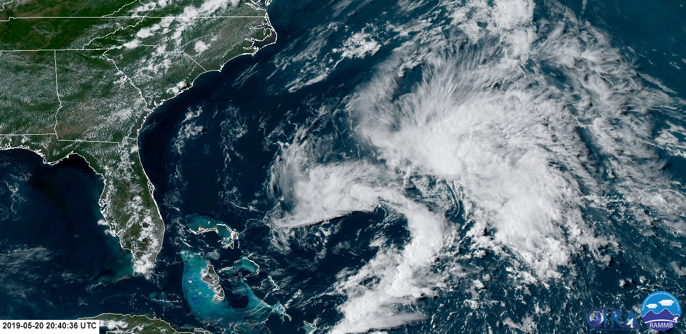
This storm forming while everyone is paying attention to the severe weather over the Plains is the atmospheric equivalent of a Friday night news dump. Most people will never know it existed, and the rest will forget about it soon enough. Subtropical Storm Andrea will probably dissipate by early Wednesday morning without affecting land. The storm’s remnants could bring showers to Bermuda by the middle of the week, but that’s about it as far as impacts are concerned.

A subtropical storm is a low-pressure system that shares both tropical and extratropical characteristics. It’s tropical-like. It forms and acts like a tropical cyclone, and carries the same impacts as a tropical cyclone, but it’s not fully warm throughout the system and it derives some of its energy from upper-level winds. A fully tropical cyclone would be warm from top to bottom and the thunderstorms near the center of the storm would completely drive its formation and maintenance.

We’re almost to the point where you can wager money on a named storm forming before June 1 and wind up winning the bet. This is the seventh hurricane season since 2009, and the fifth season in a row, that we’ve seen at least one named storm form in the “pre-season.”

I argued a few weeks ago that we should move the beginning of the Atlantic hurricane season up a few weeks into May. Not only would moving up the start of the season to, say, May 15, which would sync it up with eastern Pacific’s season, but it would start the awareness campaigns a little earlier than they run right now. That’d be helpful for coastal residents, seeing as several of these “pre-season” storms, like Alberto in 2018, wound up making landfall in the United States.

The tropics should fall quiet again for a while after Andrea dissipates.

[Top Image: RAMMB/CIRA]


You can follow me on Twitter or send me an email.

Please consider subscribing to my Patreon. Reader-funded news is more important than ever and your support helps fund engaging, hype-free weather coverage.
 

Author

Dennis Mersereau

I have 15+ of experience providing hype-free weather information for folks across the United States and around the world. In addition to DAMWeather, I also contribute to The Weather Network as a digital writer and weather specialist.

Follow Me
Other Articles
Previous

Here’s Why the Atmosphere Is Primed for a High-End Tornado Outbreak on the Plains

Next

Oklahoma Is Extremely Lucky That Monday’s Severe Weather Didn’t Live Up To Its Potential


Local ◈ UTC
Facebook | Bluesky
Instagram | Threads | Email
DAMWeather is now ad-free! Everyone benefits from engaging, hype-free weather coverage. Please consider supporting my efforts through Patreon:


Order The Skies Above today!

Bookshop.org || Barnes & Noble
Mountaineers Books || Amazon

My latest book, The Skies Above, is now available!

Did you know a puffy cloud can weigh millions of pounds? Or that every rainbow you see is unique to you?

Our atmosphere is full of spectacular sights that are always within your reach. Glistening layers of fog, gorgeous sunsets, and brilliant meteors flashing through the sky can light up even the calmest day.

The Skies Above, published by Mountaineers Books, is a celebration of what we overlook when we look up. I was thrilled to work with the editors and illustrators at Indelible Editions to share with you the quotidian beauty of our sky.

Order your copy now and learn about the wonders we take for granted every day.

I teamed up with the editors of Outdoor Life magazine to write The Extreme Weather Survival Manual, your guide to surviving and thriving in almost any weather condition. Whether you're an avid outdoorsperson or you enjoy watching the radar from the comfort of your home, you're sure to find helpful tips, advice, and new bits of knowledge in this fascinating book.

You can buy my book today through Amazon.
  • 2026 (34)
  • 2025 (49)
  • 2024 (59)
  • 2023 (43)
  • 2022 (57)
  • 2021 (71)
  • 2020 (83)
  • 2019 (88)
  • 2018 (92)
  • 2017 (1)
  • 2016 (4)
  • 2015 (10)

Copyright 2026 — DAMWeather. All rights reserved. Blogsy WordPress Theme