A Tropical Depression Is Likely In The Atlantic By Early Next Week


We could see our third named storm of the 2019 Atlantic hurricane season by this time next week. The suspect is a tropical disturbance that’s currently about halfway between the Caribbean and Africa. The National Hurricane Center gives the system a high chance of developing into a tropical cyclone as it approaches the Lower Antilles early next week.
The first week of August is when tropical activity in the Atlantic Ocean typically begins to pick up steam. Right on cue, a tropical wave that moved off the western coast of Africa last week is the likely candidate for our next tropical system. The disturbance, currently called Invest 96L for tracking purposes, is rather healthy looking at the moment as far as tropical waves go. The system has plenty of thunderstorm activity and a defined, broad “swirl” in satellite imagery.
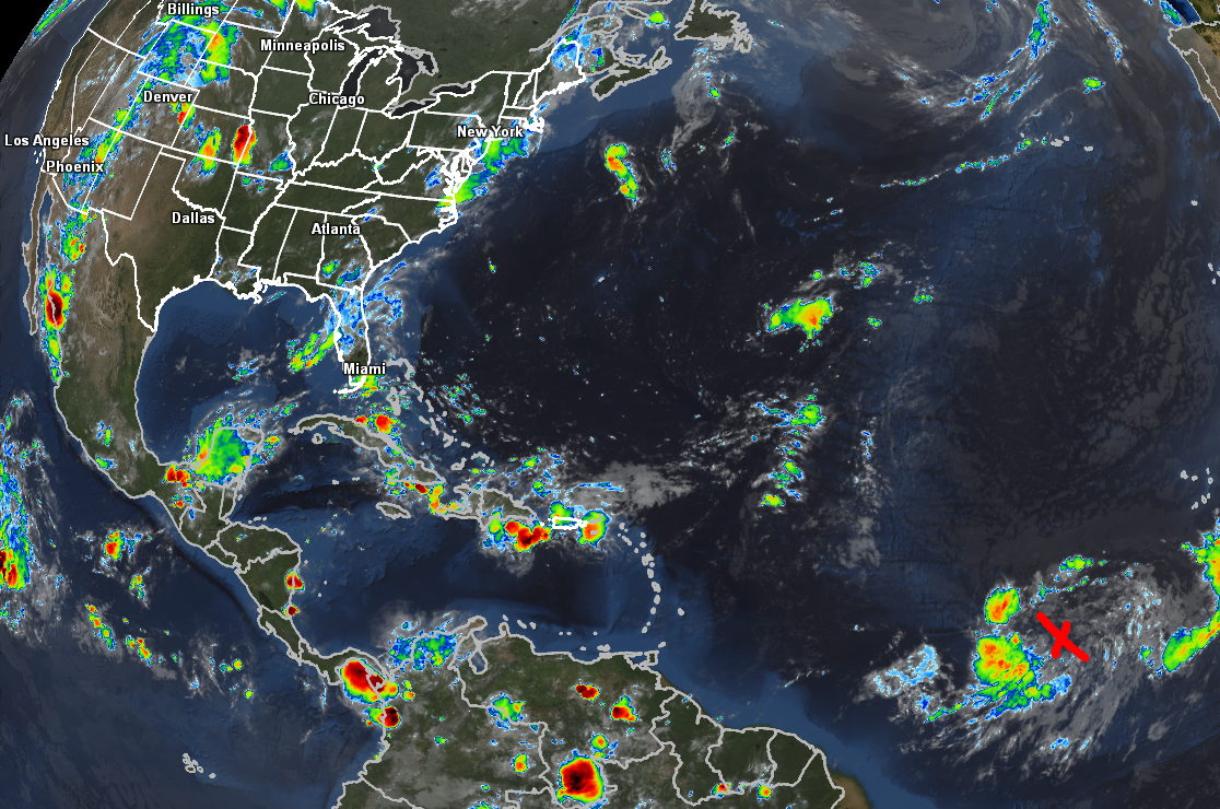 |
| Invest 96L on satellite imagery around midnight on August 1, 2019. | Source: GREarth/AllisonHouse |
A favorable environment will greet Invest 96L once it moves northeast of the Lesser Antilles next week; as a result, the National Hurricane Center gives the system a 70 percent chance of developing into a tropical depression by early next week.
It’s far too early to talk about strength. But the overall pattern in the Atlantic right now does give us an idea of the general track a potential named storm would take. The paths of most tropical cyclones that develop in this part of the Atlantic are driven by the Bermuda High, or the big dome of high pressure that dominates the middle of the Atlantic Ocean in the summer months.
A stronger high tends to push tropical cyclones closer to land, shunting them into the Caribbean or threatening The Bahamas or the U.S. East Coast. A weaker high allows the storm to begin its curve out to sea sooner, posing only a threat to Bermuda and shipping lanes in the northern Atlantic. The strength of this high—as well as a trough that’s likely to approach the East Coast late next week—will determine the path of the system (should it develop, of course).
What can you do right now? I’d say “don’t worry about it,” but I’m a weather-worrier myself. I know how it is, even something like 10 days out. Consider this a great time to make sure all of your preparations are in order even if you’re hundreds of miles inland. Take the time to inventory and gather up your supplies, documents, plans—all the stuff we should take care of at the beginning of hurricane season to begin with. If the storm forms and threatens, you’re ready. If not, you’re ready for the next one.
The National Hurricane Center issues tropical weather outlooks four times a day at 2:00 and 8:00 AM/PM Eastern. The agency won’t begin issuing official wind/track forecasts unless the storm actually develops into a tropical depression, which likely wouldn’t happen until Sunday at the earliest.
There is another disturbance the NHC has painted on its Wednesday night outlook. The system has a 10 percent chance of developing into a tropical cyclone off the southeastern coast late this weekend or early next week. I left it off of this map because it has such a low chance of developing and the fact that a big highlighted area right next to the U.S. is distracting when we’re talking about a different system thousands of miles away.
Please consider subscribing to my Patreon. Your support helps me write engaging, hype-free weather coverage—no fretting over ad revenue, no chasing viral clicks. Just the weather.