Skip to content
DAMWeather DAMWeather

The weather can get scary. Reporting on it doesn't have to be.

DAMWeather DAMWeather

The weather can get scary. Reporting on it doesn't have to be.

  • About Me
  • All Bylines
    • Books, Bylines, and Press
    • The Skies Above (Book)
    • Extreme Weather (Book)
    • The Weather Network
    • The Vane
    • Forbes
    • Capital Weather Gang
    • Mental Floss
  • Maps
    • Hurricane Maps
    • Hurricane Names
    • Monthly Tornadoes
    • Tornado Tracks
    • F5/EF-5 Tornadoes
    • SPC High Risk Days
  • GIS Resources
  • Contact Me
    • Bluesky
    • Facebook
    • Instagram
  • wxdam.com
  • About Me
  • All Bylines
    • Books, Bylines, and Press
    • The Skies Above (Book)
    • Extreme Weather (Book)
    • The Weather Network
    • The Vane
    • Forbes
    • Capital Weather Gang
    • Mental Floss
  • Maps
    • Hurricane Maps
    • Hurricane Names
    • Monthly Tornadoes
    • Tornado Tracks
    • F5/EF-5 Tornadoes
    • SPC High Risk Days
  • GIS Resources
  • Contact Me
    • Bluesky
    • Facebook
    • Instagram
  • wxdam.com
Close

Search

DAMWeather DAMWeather

The weather can get scary. Reporting on it doesn't have to be.

DAMWeather DAMWeather

The weather can get scary. Reporting on it doesn't have to be.

  • About Me
  • All Bylines
    • Books, Bylines, and Press
    • The Skies Above (Book)
    • Extreme Weather (Book)
    • The Weather Network
    • The Vane
    • Forbes
    • Capital Weather Gang
    • Mental Floss
  • Maps
    • Hurricane Maps
    • Hurricane Names
    • Monthly Tornadoes
    • Tornado Tracks
    • F5/EF-5 Tornadoes
    • SPC High Risk Days
  • GIS Resources
  • Contact Me
    • Bluesky
    • Facebook
    • Instagram
  • wxdam.com
  • About Me
  • All Bylines
    • Books, Bylines, and Press
    • The Skies Above (Book)
    • Extreme Weather (Book)
    • The Weather Network
    • The Vane
    • Forbes
    • Capital Weather Gang
    • Mental Floss
  • Maps
    • Hurricane Maps
    • Hurricane Names
    • Monthly Tornadoes
    • Tornado Tracks
    • F5/EF-5 Tornadoes
    • SPC High Risk Days
  • GIS Resources
  • Contact Me
    • Bluesky
    • Facebook
    • Instagram
  • wxdam.com
Close

Search

GOES-17, The Little Weather Satellite That Could, Survived Another Hiccup Last Night

By Dennis Mersereau
August 15, 2019 3 Min Read

The United States’ newest weather satellite survives to sense another day. GOES-17, known in service as GOES-West, suffered a 10.5-hour outage this morning after a reported software glitch caused the satellite to stop transmitting products and imagery. Engineers were able to fix the problem and the satellite began scanning the skies again this afternoon.

Meteorologists and amateur weather enthusiasts collectively held their breath this morning when NOAA said engineers were looking into a “spacecraft anomaly” that caused an outage of all visible and infrared imagery from the satellite.

The term “spacecraft anomaly” can be one of those coy euphemisms used to describe a particularly bad incident in a way that doesn’t sound so upsetting. It’s not unlike a chipper flight attendant casually describing what to do in a “water landing,” which sounds much more agreeable than “crashing into a lake.”

However, and thankfully!, things aren’t always as bad as they first seem when an “anomaly” is first spotted. This issue was reportedly a software glitch that engineers solved with a restart of the Advanced Baseline Imager (ABI), the instrument that provides us with visible, infrared, and water vapor imagery.

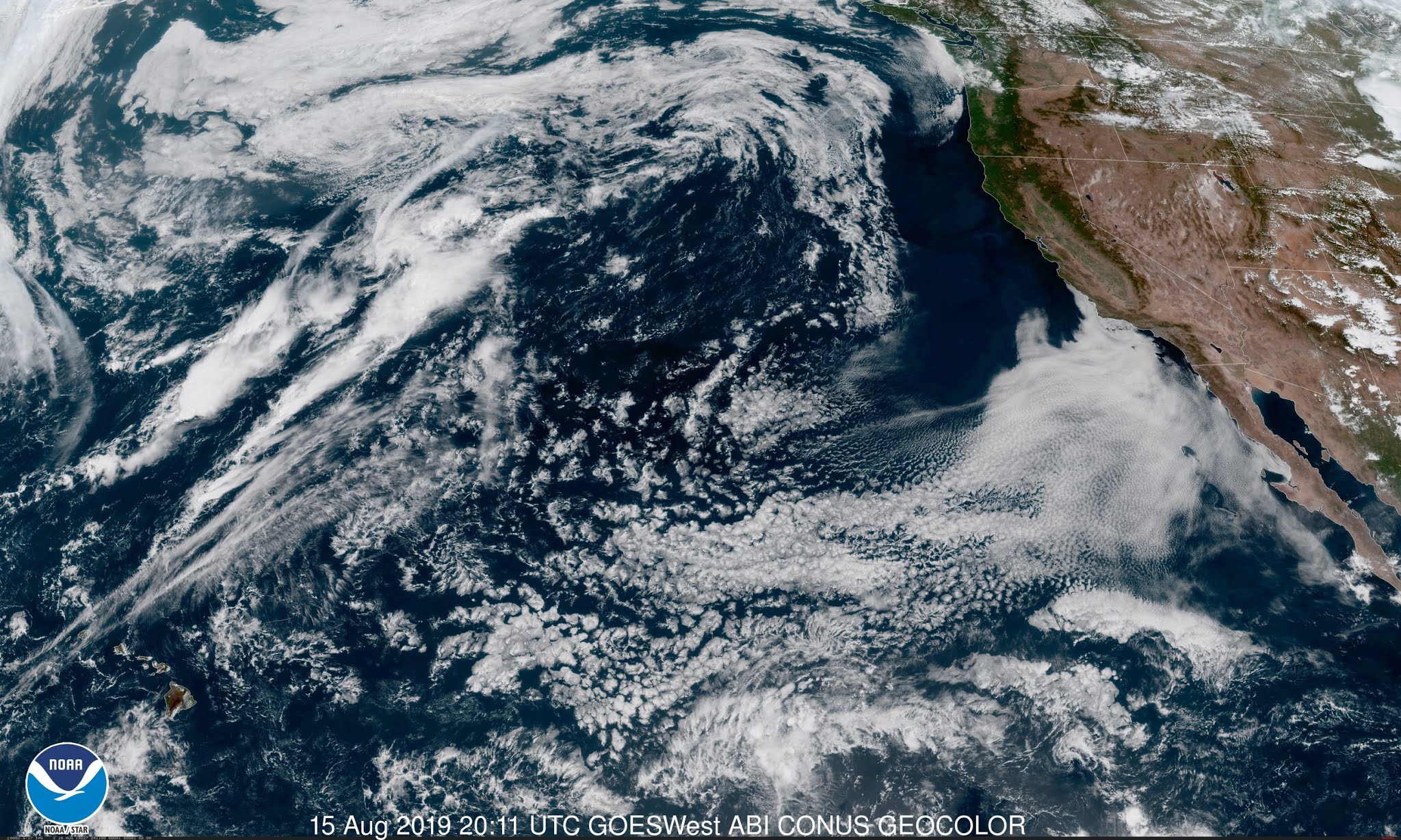
The satellite is back online and working fine now. The image at the top of this post is a view from the satellite this afternoon. (Ohh. Ahh. Pretty.)

GOES-17 Is No Stranger To Struggle

This isn’t the first time the newest GOES satellite acted up. The satellite’s ABI encountered a significant failure of its cooling system when engineers booted up the satellite for testing in the spring of 2018. NOAA concluded just two weeks ago that a clogged pipe prevented the ABI’s coolant system from working properly.
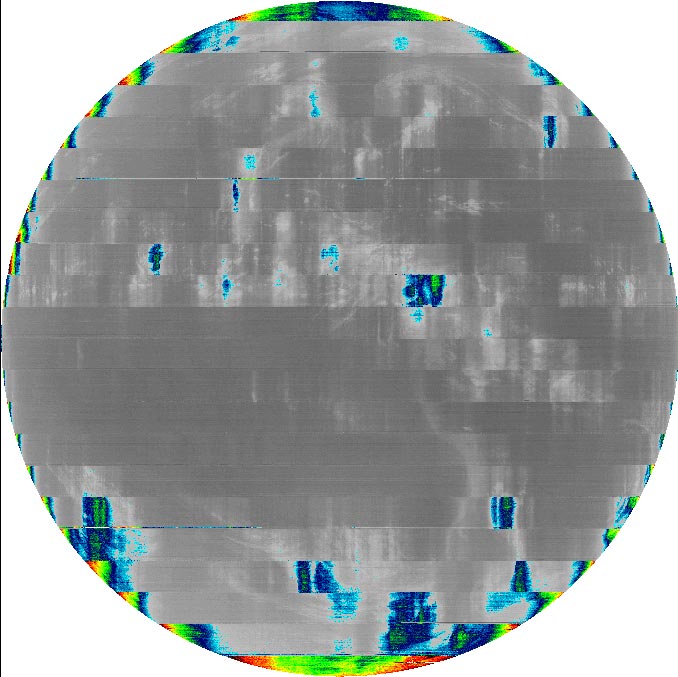
An example of interference in infrared satellite imagery caused by excess heat given off by the ABI. | NOAA

The problem seemed pretty bad at first—so bad, in fact, that it
looked like the satellite would have limited functionality that could
hamper its effectiveness.

A geostationary satellite
like GOES-17 orbits at the same speed Earth rotates,
fixing the satellite over one point on the equator. This
fixed position affords the satellite the exact same view of Earth for its
entire service life. The altitude required to achieve geostationary
orbit also exposes the ABI instrument, which faces Earth, to direct sunshine for several
hours a day around the winter and spring equinoxes.

The above picture shows why that’s a problem when the cooling system doesn’t work properly. The ABI works by sensing 16 different
spectral wavelengths (known as “bands”) to provide us with the visible,
water vapor, and infrared imagery we see in weather reports every day.
When the ABI’s cooling system fails and it overheats, the heat of the
instrument itself begins giving off longwave radiation that matches the
wavelengths used to create water vapor and infrared imagery. 

The interference from the overheating instrument leads to noisy, useless satellite imagery across the affected wavelengths for those couple of hours of direct sunshine. Engineers were able to implement fixes and workarounds that brought the satellite up to 97 percent functionality, which is pretty darn good given the bleak outlook just a few months earlier.


You can follow me on Twitter or send me an email.

Please consider subscribing to my Patreon. Your support helps me write engaging, hype-free weather coverage—no fretting over ad revenue, no chasing viral clicks. Just the weather.
 

Author

Dennis Mersereau

I have 15+ of experience providing hype-free weather information for folks across the United States and around the world. In addition to DAMWeather, I also contribute to The Weather Network as a digital writer and weather specialist.

Follow Me
Other Articles
Previous

The Eye Of A Powerful Typhoon Abruptly Swerved Around This Japanese Island

Next

Tropical Storm Chantal Forms Out In The Middle Of Nowhere


Local ◈ UTC
Facebook | Bluesky
Instagram | Threads | Email
DAMWeather is now ad-free! Everyone benefits from engaging, hype-free weather coverage. Please consider supporting my efforts through Patreon:


Order The Skies Above today!

Bookshop.org || Barnes & Noble
Mountaineers Books || Amazon

My latest book, The Skies Above, is now available!

Did you know a puffy cloud can weigh millions of pounds? Or that every rainbow you see is unique to you?

Our atmosphere is full of spectacular sights that are always within your reach. Glistening layers of fog, gorgeous sunsets, and brilliant meteors flashing through the sky can light up even the calmest day.

The Skies Above, published by Mountaineers Books, is a celebration of what we overlook when we look up. I was thrilled to work with the editors and illustrators at Indelible Editions to share with you the quotidian beauty of our sky.

Order your copy now and learn about the wonders we take for granted every day.

I teamed up with the editors of Outdoor Life magazine to write The Extreme Weather Survival Manual, your guide to surviving and thriving in almost any weather condition. Whether you're an avid outdoorsperson or you enjoy watching the radar from the comfort of your home, you're sure to find helpful tips, advice, and new bits of knowledge in this fascinating book.

You can buy my book today through Amazon.
  • 2026 (37)
  • 2025 (49)
  • 2024 (59)
  • 2023 (43)
  • 2022 (57)
  • 2021 (71)
  • 2020 (83)
  • 2019 (88)
  • 2018 (92)
  • 2017 (1)
  • 2016 (4)
  • 2015 (10)


Copyright 2026 — DAMWeather. All rights reserved. Blogsy WordPress Theme