Skip to content
DAMWeather DAMWeather DAMWeather

The weather can get scary. Reporting on it doesn't have to be.

DAMWeather DAMWeather DAMWeather

The weather can get scary. Reporting on it doesn't have to be.

  • About Me
  • All Bylines
    • Books, Bylines, and Press
    • The Skies Above (Book)
    • Extreme Weather (Book)
    • The Weather Network
    • The Vane
    • Forbes
    • Capital Weather Gang
    • Mental Floss
  • Maps
    • Hurricane Maps
    • Hurricane Names
    • Monthly Tornadoes
    • Tornado Tracks
    • F5/EF-5 Tornadoes
    • SPC High Risk Days
  • GIS Resources
  • Contact Me
    • Bluesky
    • Facebook
    • Instagram
  • wxdam.com
  • About Me
  • All Bylines
    • Books, Bylines, and Press
    • The Skies Above (Book)
    • Extreme Weather (Book)
    • The Weather Network
    • The Vane
    • Forbes
    • Capital Weather Gang
    • Mental Floss
  • Maps
    • Hurricane Maps
    • Hurricane Names
    • Monthly Tornadoes
    • Tornado Tracks
    • F5/EF-5 Tornadoes
    • SPC High Risk Days
  • GIS Resources
  • Contact Me
    • Bluesky
    • Facebook
    • Instagram
  • wxdam.com
Close

Search

Tropical Storm Chantal Forms Out In The Middle Of Nowhere

By Dennis Mersereau
August 21, 2019 3 Min Read


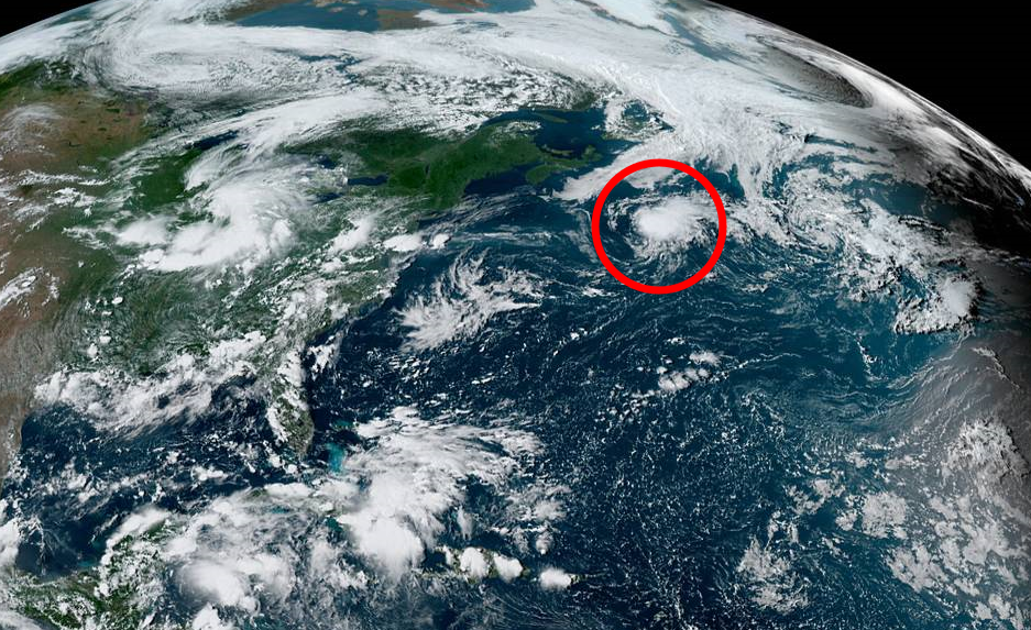
A disturbance in the northern Atlantic Ocean developed into Tropical Storm Chantal on Tuesday evening, becoming the third named storm of the unusually quiet-to-this-point Atlantic hurricane season. Forecasters expect the storm to remain far out in the north-central Atlantic, posing a threat to no one but some ships and maybe a floating beach ball or whatever.
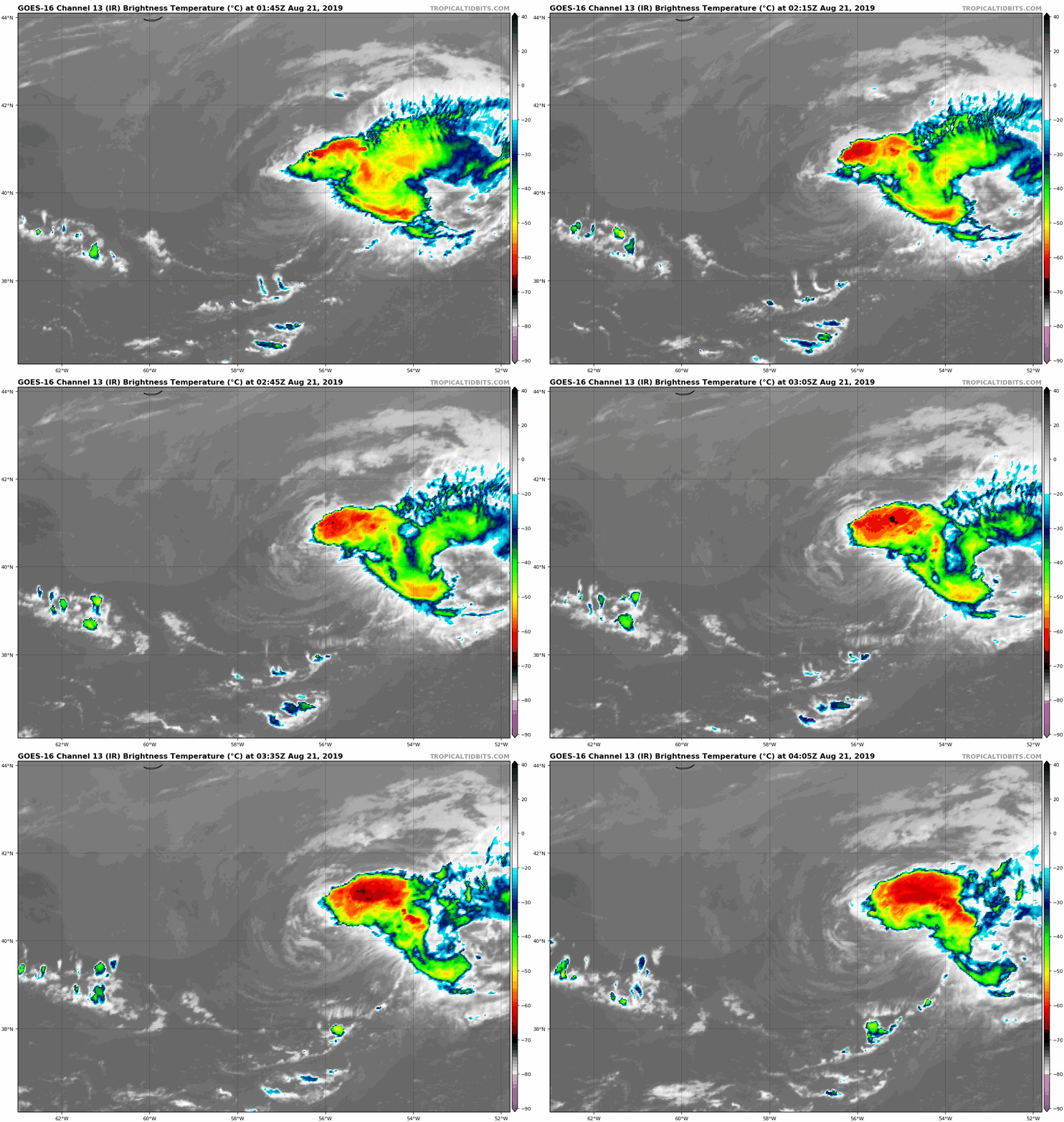
An infrared satellite loop of Tropical Storm Chantal on the evening of August 20, 2019 | Tropical Tidbits

The National Hurricane Center began mentioning this disturbance in its tropical weather outlooks last Friday, and it remained at a 10 percent chance of development until the system began to get its act together on Tuesday morning. Hey—a 10 percent chance is still a chance.

The system became Tropical Storm Chantal after developing a sustained patch of thunderstorms this morning, which in turn induced the development of a closed circulation at the surface. Westerly wind shear is keeping the system from looking its best tonight. The storm is moving east at a decent clip and its thunderstorms are all confined to the east of the center of circulation.

This tropical storm is what you stare at when you’re a bored weather
enthusiast aimlessly wandering around the internet looking for something
to do on a late summer weeknight. It’s underwhelming, but it’s better
than watching a King of Queens rerun on TV Land for the 87th time.

Tropical Storm Chantal should remain far out in the central Atlantic Ocean; the 11:00 PM EDT forecast shows the system barely clinging to tropical storm status as it wanders somewhere between Bermuda and The Azores. A cone of uncertainty forms a haphazard blob over the central Atlantic as a result of the storm’s expected curly track toward the end of its life cycle—if it survives that long, of course.

Chantal is the first storm we’ve seen in the Atlantic since Hurricane Barry made landfall on the northern Gulf Coast in the middle of July. That’s the longest mid-summer quiet stretch since at least the early 80s. We’re approaching peak season and it doesn’t take much for one storm to turn into a serious threat if it approaches land. Even though it’s quiet and we’re talking about one thunderstorm over a semi-naked wind swirl right now, it’s wise to make visiting the National Hurricane Center a part of your daily routine for the next month or two. Things can change in a hurry.


You can follow me on Twitter or send me an email.

Please consider subscribing to my Patreon. Your support helps me write engaging, hype-free weather coverage—no fretting over ad revenue, no chasing viral clicks. Just the weather.
 

Author

Dennis Mersereau

I have 15+ of experience providing hype-free weather information for folks across the United States and around the world. In addition to DAMWeather, I also contribute to The Weather Network as a digital writer and weather specialist.

Follow Me
Other Articles
Previous

GOES-17, The Little Weather Satellite That Could, Survived Another Hiccup Last Night

Next

President Trump (Allegedly) Wants To Know If We Can Stop A Hurricane With Nuclear Bombs


Local ◈ UTC
Facebook | Bluesky
Instagram | Threads | Email
DAMWeather is now ad-free! Everyone benefits from engaging, hype-free weather coverage. Please consider supporting my efforts through Patreon:


Order The Skies Above today!

Bookshop.org || Barnes & Noble
Mountaineers Books || Amazon

My latest book, The Skies Above, is now available!

Did you know a puffy cloud can weigh millions of pounds? Or that every rainbow you see is unique to you?

Our atmosphere is full of spectacular sights that are always within your reach. Glistening layers of fog, gorgeous sunsets, and brilliant meteors flashing through the sky can light up even the calmest day.

The Skies Above, published by Mountaineers Books, is a celebration of what we overlook when we look up. I was thrilled to work with the editors and illustrators at Indelible Editions to share with you the quotidian beauty of our sky.

Order your copy now and learn about the wonders we take for granted every day.

I teamed up with the editors of Outdoor Life magazine to write The Extreme Weather Survival Manual, your guide to surviving and thriving in almost any weather condition. Whether you're an avid outdoorsperson or you enjoy watching the radar from the comfort of your home, you're sure to find helpful tips, advice, and new bits of knowledge in this fascinating book.

You can buy my book today through Amazon.
  • 2026 (34)
  • 2025 (49)
  • 2024 (59)
  • 2023 (43)
  • 2022 (57)
  • 2021 (71)
  • 2020 (83)
  • 2019 (88)
  • 2018 (92)
  • 2017 (1)
  • 2016 (4)
  • 2015 (10)

Copyright 2026 — DAMWeather. All rights reserved. Blogsy WordPress Theme