The Tropical Atlantic Grows Active Again After An Unusually Long Midsummer Silence


It’s been an unusually quiet summer so far in the Atlantic Ocean. We didn’t see a named storm between Hurricane Barry making landfall on July 17 until weak ol’ Tropical Storm Chantal formed in the oceanic boondocks early last week. That quiet trend is coming to an end, right on time for the peak of hurricane season.
Tropical Storm Dorian Approaching The Caribbean

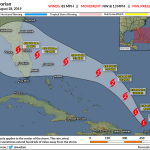
A tropical wave managed to survive the persistently dry and dusty air puffing off of the western African coast, developing into Tropical Storm Dorian on Saturday afternoon out in the tropical Atlantic.
I wrote a detailed post about the storm over at my Forbes blog on Saturday night. This is the first storm we’ve seen so far this season that’s actually developed in the tropics. The NHC expects the storm to enter a window of favorable conditions for strengthening, so their forecast shows Dorian reaching hurricane strength by the time it enters the Caribbean on Tuesday. There’s a chance that the storm could undergo rapid intensification at some point over the next couple of days, so a storm like this can quickly grow serious sooner than expected.
It’s scary to see Puerto Rico in the cone of uncertainty. Puerto Rico—which, by the way, is a territory of the United States
and whose residents are American citizens—is still struggling to recover
from Hurricane Maria in September 2017. Maria made a direct strike on
the island as a major hurricane; thousands of people died during the
storm and in the prolonged suffering that followed. Many parts of the
island weren’t reconnected to the power grid for months after the storm.
The island territory’s situation at the moment is
precarious at best—a faltering economy, survivors trying to get back on
their feet after the first storm, a local government in chaos, and a
federal government run by individuals who couldn’t seem to care less about the continued suffering of several million American citizens on American soil—so even a glancing blow by a storm of any strength comes with a heightened potential for harm.
Watching Invest 98L
 |
| Invest 98L off the southeastern coast on August 26, 2019. || College of DuPage |
The other disturbance out in the Atlantic right now is Invest 98L, a slow-moving system that’s been meandering off the Florida coast since last week.
Models look a lot less favorably on this system than they did a few days ago. Nevertheless, the NHC gives this system a high chance of developing into tropical cyclone as it slowly moves away from the East Coast through midweek. It doesn’t look like there’s an immediate threat to the East Coast as a cold front approaches from the west, but it’s good to stay vigilant every day
through the end of hurricane season—when you’re keeping tabs on
everything, very few things have the chance to surprise you.
It’s Been A Quiet Summer. (That’s A Good Thing!)
It’s uncommon to see such a long stretch in the middle of summer without a named storm anywhere in the Atlantic. We didn’t see one named storm in the Atlantic Basin between July 13, when Hurricane Barry made landfall on Louisiana, and when Tropical Storm Chantal developed this past Monday. We had one tropical depression near Florida about a week after Barry made landfall, but it only managed to last for 18 hours. (Really!)
Such a long period of silence between mid-July and mid-August is one of the longest midsummer stormless stretches we’ve seen in the satellite era, rivaled only by a couple of slow hurricane seasons in recent decades. A quiet start to hurricane season is good news for folks who live near the coasts for obvious reasons, but this silence also gives people plenty of time to prepare for when tropical activity inevitably starts to pick up in a couple of weeks as we approach the peak of hurricane season.
El Niño Is Gone
Forecasters continue to predict a near- or above-average Atlantic hurricane season this year due to a waning El Niño in the eastern Pacific Ocean. This forecast accounts for the number of tropical storms and hurricanes we’ll see in a given year—an average year sees 12 named storms, 6 hurricanes, and 3 major hurricanes. We’ve already seen three tropical storms and one hurricane this year.
One large-scale factor that plays an indirect role in the Atlantic
Ocean’s tropical activity is El Niño, which occurs when water around the
equator in the eastern Pacific Ocean grows abnormally warm for many
months at a time. This warming can generate excess thunderstorm activity
in the eastern Pacific, which in turn creates wind shear that can
suffocate any disturbances trying to develop over in the Atlantic.
The
National Weather Service reported on August 8 that the El Niño that
began last fall has finally subsided. The agency predicts that we’ll remain in a neutral state—no
El Niño or La Niña—through the balance of hurricane season, which could
lessen that destructive wind shear and make conditions a little more
favorable for tropical development in the coming months.
Another major factor in this year’s oceanic snoozefest is dry, dusty air blowing off the western coast of Africa. These pulses of arid desert air choke off any convection that tries to form in areas we would typically watch for tropical development. A tropical cyclone can’t form out of thin air—it has to form from an existing complex of thunderstorms, and those can’t exist if dry air keeps chomping away at them.
It’s not good to seek security in the raw number of named storms. Some
of our most destructive hurricanes formed in “slow” hurricane seasons,
and rain is often the greatest threat of any landfalling system—even
unnamed tropical disturbances.
Please consider subscribing to my Patreon. Your support helps me write engaging, hype-free weather coverage—no fretting over ad revenue, no chasing viral clicks. Just the weather.