Four Different Weather Headaches Will Snarl Thanksgiving Travel This Week

It wouldn’t be Thanksgiving week without nasty weather. Several storms will move across the country through the holiday weekend, providing ample opportunities for disruption to airline and highway travel just in time for the holiday rush. It’s a good idea to take the next day or two to prepare for travel snarls in advance so you’re not stuck halfway between home and a turkey dinner.
Headache #1: Major Pacific Storm | Timing: Tues-Weds
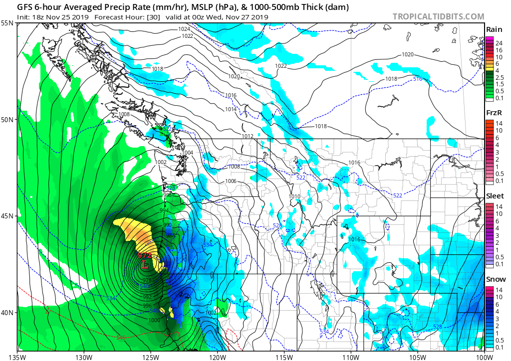 |
| GFS model guidance showing the strong low off the coast of Oregon on Tuesday evening. Source: Tropical Tidbits |
A powerful storm will move across parts of Oregon and California on Tuesday evening, bringing the potential for damaging winds, heavy rain, and several feet of mountain snows through Thanksgiving. Heavy snow will make it difficult, if not impossible, to drive across the mountains on Wednesday, which will severely hamper traffic on one of the busiest travel days of the year.
The National Weather Service in Medford, Oregon, characterized the storm in unambiguous terms on Monday night: “this low is unprecedented in its strength and track.” A strong jet stream diving south over the Pacific Northwest will allow a developing low-pressure system to rapidly strengthen over the next day or so. The low’s minimum central pressure could get down into the low 970s, which would be impressive for a hurricane let alone an extratropical cyclone in this part of the country.
In fact, if the forecast air pressures come to pass, the storm could break all-time record low air pressure readings in southwestern Oregon and northwestern California. According to the Weather Prediction Center, the all-time record low air pressure at Medford, Oregon, was 978.0 mb, and 978.7 in Eureka, California. It’s likely that these records would fall if the core of the low moved over or very close to one of these stations.
Winds
 |
| Source: NWS Medford |
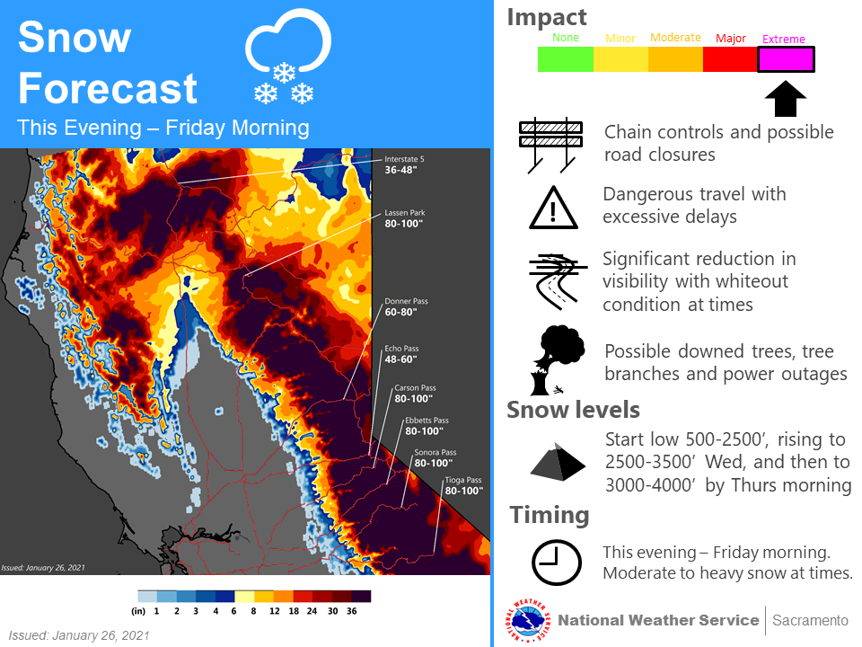
Damaging winds are a serious threat from a system this strong. Wind gusts in excess of 70 MPH are possible along and near the coast in southwestern Oregon and northwestern California. Higher gusts are likely at higher elevations. Winds this strong will easily knock down trees and power lines, potentially leading to widespread power outages. Trees and limbs falling across roads will pose a hazard to vehicles and homes.
Heavy Rain
This will be a fast-moving storm, which doesn’t give it much time to drop a ton of rain all at once. (Remember, steady rain quenches the ground but torrential rain runs off before it can soak in.) The latest forecast from the Weather Prediction Center shows more than an inch of rain across most lower elevations in southern Oregon and northern California.
Heavy Snows
This storm will produce several feet of snow in the mountains of eastern California, which is great news for ski resorts but terrible news for travelers who are hoping to drive east for the long holiday weekend. It’s worth considering alternate plans for Thanksgiving if you’re planning to cross the mountains on a road like I-80.
Headache #2: Central U.S. Winter Storm | Timing: Tues-Weds

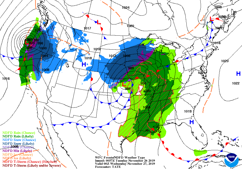
A classic winter storm developing along the Front Range on Monday evening will move toward the Great Lakes through Wednesday, blanketing a stretch between Denver and Marquette with a solid, shovelable snow. Thunderstorms and high winds will follow a cold front across the southern Plains through Tuesday evening, bringing the potential for severe thunderstorms to the lower Mississippi River Valley.
It’s already snowing in Colorado and Wyoming, where communities like Boulder, Fort Collins, and Cheyenne, could wind up with a foot or more of snow by the time the storm is over on Tuesday evening. The storm will continue producing snow across the central Plains as it makes its way toward the Great Lakes. Another burst of 12″+ totals is possible in northern Wisconsin and Michigan’s Upper Peninsula, where the storm’s snow is enhanced by Lake Superior.
The warmer side of the system will produce high winds across the southern Plains, where high winds warnings are in effect for much of eastern New Mexico, western Oklahoma, and the Texas Panhandle in anticipation of wind gusts as high as 70 MPH after the cold front passes through on Tuesday. High winds and dry air will lead to an increased threat for wildfires across these areas.
Severe thunderstorms are possible in the lower Mississippi River Valley on Tuesday evening as the cold front pushes into warm, humid air. The Storm Prediction Center painted a slight risk across the area, which includes St. Louis, Little Rock, and Memphis. The storms are likely going to develop along the cold front in the form of one or more broken squall lines, posing the threat for damaging wind gusts and possibly a couple of tornadoes. Tornadoes are most likely in broken lines, where individual thunderstorms have an easier time tapping into low-level rotation.
Headache #3: SoCal Rain | Timing: Weds-Sat
 |
| Source: NWS San Diego |
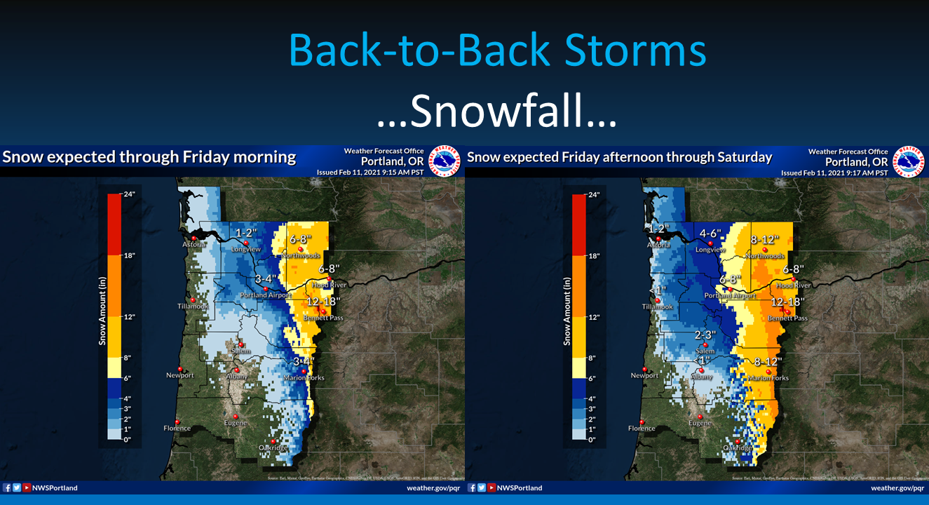
An inch or two of rain isn’t too big of a deal for us east of the Rockies, but it’s an errand-stopping ordeal in southern California. Heavy rain and maybe even a few rumbles of thunder are possible in southern California as a surge of moisture moves across the southwestern United States later this week. Several inches of rain could fall in southern California beginning on Wednesday and lasting through Saturday. Flash flooding is possible if the rain falls too quickly, especially in areas that saw wildfires in recent years.
It’s likely that the rain will lead to flight delays at LAX just in time for the busiest flying day of the year. Rainy, gloomy weather requires air traffic controllers to slow down operations so they can safely maneuver the planes as they’re arriving and departing. Pilots and controllers need a little breathing room in the rain, and it takes a little longer for planes to stop on wet runways. Even a small slowdown will cause a ripple effect of delays and cancellations down the line, since individual planes often complete so many legs in a day.
Headache #4: Southwest Snowstorm | Timing: Thurs-Fri
 |
| Source: NWS Flagstaff |
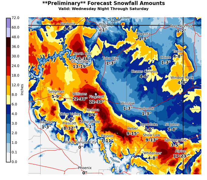
A significant winter storm will unfold at higher elevations in Arizona, where several feet of snow could fall from the Grand Canyon to the White Mountains. Flagstaff could see more than two feet of snow by the beginning of the weekend. This kind of snow will snarl traffic along highways that traverse the northern half of Arizona. Crews should have the roads clear and open again in time for folks to head back home this weekend.
Please consider subscribing to my Patreon. Your support helps me write engaging, hype-free weather coverage—no fretting over ad revenue, no chasing viral clicks. Just the weather.