Dangerous Severe Thunderstorms Are Likely Across The South On Friday And Saturday


A dangerous mid-winter severe weather outbreak will roll across several southern states on Friday and Saturday, bringing the potential for all types of severe weather, including flash flooding. The threat will begin late Friday morning in Texas and slowly shift east through Saturday night.
Severe Weather Risk
The Storm Prediction Center issued a moderate risk for severe weather for parts of the Deep South on Friday, which is a risk more common of mid-April than mid-January. A moderate risk is a 4 out of 5 on the ascending scale used to measure the risk for severe weather.
The moderate risk covers a large portion of Texas, Louisiana, Oklahoma, and Arkansas, including Dallas, Shreveport, and quite a few smaller cities in between. Forecasters pulled the trigger on the moderate category due to the risk for significant, widespread wind gusts in excess of 70 MPH. While the red shading will get all the headlines, it’s important to remember that damaging winds, tornadoes, large hail, and flash flooding certainly aren’t confined to the moderate risk area. The overall threat for severe storms covers a swath from the U.S./Mexico border to St. Louis.
Damaging winds are the main threat with the storms on both Friday and Saturday, but don’t discount the potential for some strong tornadoes. Supercells that develop ahead (or within) the lines of thunderstorms will be able to produce tornadoes, especially if they manage to break away from surrounding storms and take full advantage of the environment around them.

Saturday’s storms carry much the same risk as Friday’s storms—damaging winds in excess of 70 MPH, tornadoes (some potentially strong), large hail, and flooding rains—just farther east toward the northern Gulf Coast.
Timing
Severe thunderstorms are possible across Texas and Oklahoma as early as midday Friday, growing in coverage and intensity as the day wears on. The storms will organize and move into the most favorable environment for severe weather by Friday evening. The line (or line segments) will continue tracking east through Louisiana and Arkansas overnight on Friday into Saturday, reaching Mississippi and Alabama by Saturday morning.
It’s helpful to think of this as one long severe weather event. Once the storms develop on Friday afternoon, the threat for severe thunderstorms marches east straight through Saturday night. A broken line of strong storms could even make it to the Carolinas by Sunday morning.
Severe weather taking place after dark makes it even more difficult to get the word out and keep up with rapidly changing conditions. It’s tough to deal with nighttime severe weather because 1) people are asleep and 2) people like looking outside before they take cover. Make sure you’ve got emergency alerts activated on your smartphone so you can hear a tornado warning the moment one is issued for your location. If possible, it’s a good idea to hold off going to sleep until the threat for severe weather passes.
The Setup
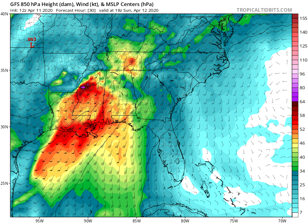 |
| The GFS model’s guidance for winds about 5,000 feet above ground level around 12:00 AM on Saturday, January 11. (Tropical Tidbits) |
A low-pressure system will develop over Oklahoma on Friday morning, setting the scene for the severe weather we’ll see over the next couple of days. The real story is the wind.
Winds will be ripping in the lower levels of the atmosphere ahead of the cold front, where a “low-level jet”—a localized area of strong winds—could produce winds stronger than 100 MPH just a few thousand feed above the surface. It’s dangerous to deal with such strong winds so low in the atmosphere because it wouldn’t take much of a downdraft for a thunderstorm to push those damaging winds down to the surface (hence the hullabaloo). A strong low-level jet can also increase the risk for supercells and tornadoes.
Flooding Risk

Damaging winds and tornadoes aren’t the only threat over the next couple of days. Showers and thunderstorms will bring a risk for flash flooding for a huge swath of the country from Texas to upstate New York. Several inches of rain are possible even in areas that aren’t expecting any severe thunderstorms. This kind of heavy, persistent rain will push natural waterways and drainage systems to their limit, especially if the rain falls quickly. The heaviest totals are likely across areas where severe thunderstorms as possible, where the Weather Prediction Center calls for more than 5 inches of rain in some spots.
Please consider subscribing to my Patreon. Your support helps me write engaging, hype-free weather coverage—no fretting over ad revenue, no chasing viral clicks. Just the weather.