Two Different Tropical Systems Could Threaten The Southern U.S. Early Next Week


The United States could deal with two different tropical cyclones making landfall in the southern states next week. It’s an odd setup with lower forecast confidence than usual. The threat exists, though, and anyone who lives in the southern United States needs to closely watch the forecasts and prepare now for the potential for flooding rains and gusty winds.
The formation of these two systems shouldn’t come as a huge surprise to folks who check the weather every day. We’ve watched these two disturbances since they rolled off the western coast of Africa days ago. Even though these two systems are developing at about the same time and they could arrive in the United States at about the same time, they’re two very different systems that are interacting with different environments.
Tropical Depression Thirteen — Atlantic

Between the two storms, T.D. Thirteen appears as if it’s moving into the most favorable environment for strengthening. If it can survive the next day or so, and that seems to be a big if, the system will move into an environment with warm waters and low wind shear, which should allow the system to slowly strengthen as it moves toward Florida over the next five days.
The greatest uncertainty around the system right now involves its current structure. It’s difficult for meteorologists and model guidance to get a good handle on a storm’s ultimate track and intensity before it develops. Right now, T.D. Thirteen is rather disorganized, without much of an inner core for the system to take root and develop. It’s really struggling to hang on at the moment. Once and if the system develops that solid inner core, we’ll have a better idea of what it’ll look like by the time it approaches the United States.
Tropical Depression Fourteen — Western Caribbean

T.D. Fourteen is the greatest threat to land at the moment. Tropical storm warnings are in effect for the coast of Honduras as the system isn’t too far off land right now. The NHC warns the storm could produce 2-4 inches of rain in Honduras and 3-6 inches in the Yucatan Peninsula, leading to the potential for flash flooding and mudslides. Higher totals are possible on the windward side of mountains.
Other than the system’s disheveledness, two of the biggest factors that play into its future are land interaction and wind shear. The system is expected to make landfall twice before it reaches the Gulf; first in Honduras tomorrow, then again on the Yucatan Peninsula later this weekend. The structure of this system will determine how much of an effect the land has on its future. A stronger and more organized system will have an easier time surviving a brief landfall than a sloppy system.
High-Stakes Watching And Waiting
It’s pretty rare to have two different storms approach the United States at roughly the same time. Maddening as it is, this is one of those situations where we’ll have to watch and wait to see how the systems develop. We should have a much clearer picture on Friday and Saturday once (and if) the systems get organized and weather models have a chance to ingest data collected in and around the systems by Hurricane Hunter aircraft.
This is the time to prepare for whatever happens next. Make sure you’ve got the supplies necessary to deal with a power outage. If you live in an area where evacuations may be necessary, know where you’ll go ahead of time. Some communities may alter or shutter their community shelters in response to the coronavirus pandemic. It’s tough to deal with multiple crises at once. Planning in advance lets you make the best decision for yourself and your family.
More Name Records?
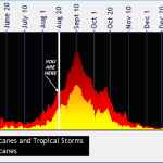
If both of these depressions reach tropical storm status, this hurricane season will have seen the earliest C, E, F, G, H, I, J, K, L, and M storms on record. The current record for the earliest twelfth (“L”) named storm on record is Hurricane Luis on August 29, 1996. The current record for the earliest thirteenth (“M”) named storm on record is Hurricane Maria on September 2, 2005.
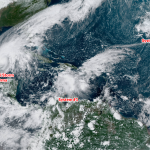
However, for right now, they’re still tropical depressions and haven’t achieved a name yet. Just remember that Thirteen is in the Atlantic and Fourteen is in the Caribbean. Which one gets which name isn’t too much of a big deal. (Or, maybe it is.)
[Satellite: NOAA]
You can follow me on Twitter or send me an email.
Please consider subscribing to my Patreon. Your support helps me write engaging, hype-free weather coverage—no fretting over ad revenue, no chasing viral clicks. Just the weather.