Tropical Storm Beta Could Pose A Major Flash Flood Threat For Texas & Louisiana Next Week


Tropical Storm Beta could bring copious amounts of rain to coastal communities in Texas and Louisiana through next week as it meanders toward the western Gulf of Mexico. The system is another slow-mover and its precise track will determine who sees the worst winds and rain. Folks along the coast from Corpus Christi to Lafayette should prepare for the potential for strong winds and flooding rains.
It seems like we can’t go more than two weeks this hurricane season without talking about another tropical system threatening to create a flash flood emergency. Beta comes just a week after Hurricane Sally itself stalled off the northern Gulf Coast before rapidly strengthening as it made a painfully slow approach into southern Alabama. Last week’s hurricane produced more than two feet of rain over the western Florida Panhandle.
 |
| Source: NOAA |
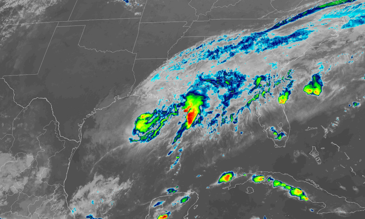
Beta is…not a looker. If you didn’t know what you were looking for, it’d be hard to pick the storm out of a lineup based on this evening’s infrared satellite imagery. Thunderstorms around the center of circulation aren’t all that deep or powerful, lending the system an underwhelming appearance on infrared satellite, which measures the temperature of the cloud tops. Stronger thunderstorms push clouds higher into the atmosphere, so colder cloud tops reveal deeper thunderstorm activity.
 |
| Source: Tropical Tidbits |
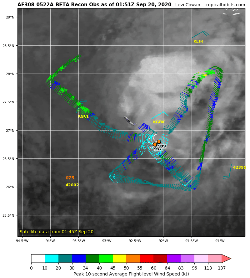
Nevertheless, Hurricane Hunter aircraft flying through the storm this evening found maximum sustained winds of 60 MPH—not too shabby for a tropical storm, especially a storm with an appearance only mother nature could love. The chart above shows this evening’s recon data plotted out by Tropical Tidbits. This image makes it easy to see how the convection isn’t quite linked up with the surface circulation—this is why the storm isn’t strengthening like Laura and Sally did once they hit the hot waters of the Gulf.

The National Hurricane Center‘s latest advisory found a strong Tropical Storm Beta in the western Gulf of Mexico, packing sustained winds of 60 MPH and a tropical-storm-force wind field that measures almost 400 miles across. Forecasters expect Beta to slowly loop back toward the coast by early next week. There’s a low chance that Beta will strengthen into a hurricane as it approaches the coast.
All hazards are possible with this tropical storm, including gusty winds that could lead to widespread power outages, a dangerous storm surge along the coast, tornadoes in the storm’s outer bands, and flash flooding from heavy rain. Flash flooding is going to be the greatest threat from this system.
Here’s the Weather Prediction Center‘s rainfall forecast for the next seven days:

A tremendous amount of rain could fall over the Gulf Coast over the next couple of days. Double-digit rainfall totals are possible from Port Lavaca to Houma, including the Houston metro area and southwestern Louisiana.
This kind of rainfall forecast is sensitive for folks in this region. The heavy rain will fall across areas devastated by Hurricane Harvey’s flooding in 2017 and by Hurricane Laura just a couple of weeks ago. The best line of defense against a storm like this is to be prepared. Have a plan and supplies ready if you live in a flood-prone area, and keep plenty of alternate routes in mind if you travel across roads that easily flood during heavy rain.
Keep in mind the potential for power outages as a result of strong winds putting stress on trees and power lines on rain-soaked soil.
Tropical Storm Beta’s precise track will determine how much rain falls and where the greatest threat lies. If the system dawdles farther offshore, that’s much better news for coastal residents than if the center of circulation scrapes along the coastline like the NHC’s forecast calls for right now. Tropical Storm Beta’s future track is a little uncertain since the system is moving so slow and it’s not particularly well organized.
 |
| Source: Tropical Tidbits |
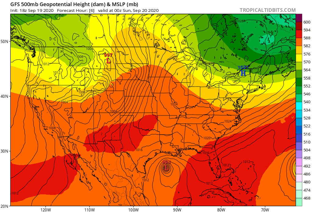
Two different ridges of high pressure—a large ridge over the center of the country and another ridge over Florida and The Bahamas—will block Beta from simply following on Sally’s heels or jetting east out into the open Atlantic. There’s not much out there to steer the storm along, forcing the system to putter around in the western Gulf for a few days. It’ll slowly creep around the outer periphery of that high pressure over the southeast, guiding it into the Texas coast. This kind of hesitating putter is why this system has the potential to produce so much rain.
If you’re wondering where this system came from…Tropical Storm Beta formed from a disturbance that’s been lingering in the Gulf of Mexico since before Hurricane Sally entered the picture. The disturbance from which Beta formed first appeared in the eastern Gulf of Mexico more than a week ago. I mentioned the system in a post on September 11, since it was one of six areas of interest across the Atlantic Ocean that day.
That disturbance slowly found its way into the western Gulf of Mexico and conditions eventually improved enough for the disturbance to strengthen into a tropical depression. The depression spent a few days getting itself together before it developed into Tropical Storm Beta on Friday afternoon.
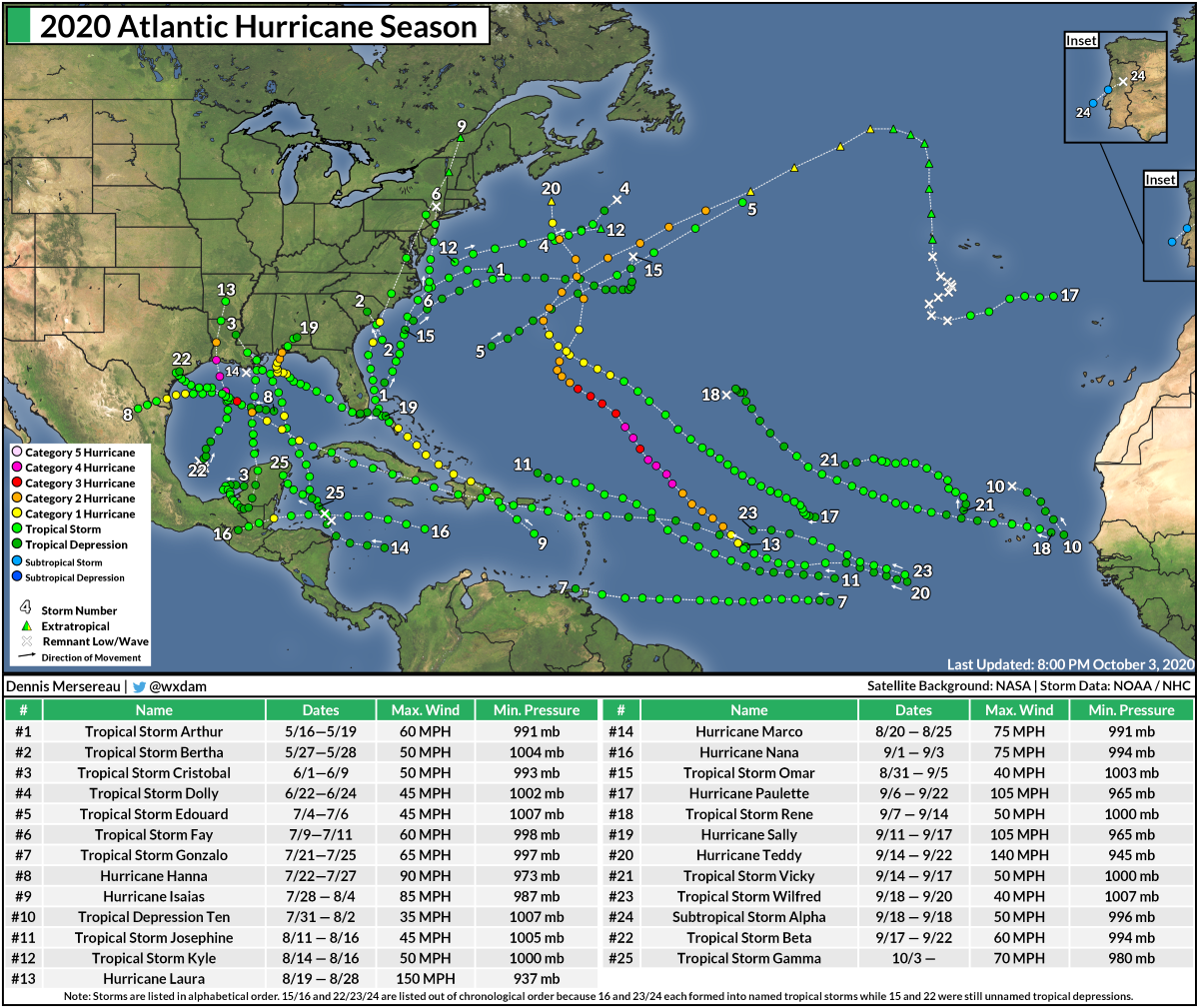
Beta is the 23rd named storm of the 2020 Atlantic hurricane season. This is only the second year on record (after 2005) that we’ve exhausted the official list of 21 names and had to resort to Greek letters to name storms. Wilfred, Alpha, and Beta were all named within a few hours of each other on Friday, September 18th. Wilfred will quietly dissipate in the eastern Atlantic, while a subtropical storm making landfall in Portugal earned the distinction of becoming Subtropical Storm Alpha.
After Beta, the next three storms will be called Gamma, Delta, and Epsilon. We still have eleven weeks left in hurricane season.
You can follow me on Twitter or send me an email.
Please consider subscribing to my Patreon. Your support helps me write engaging, hype-free weather coverage—no fretting over ad revenue, no chasing viral clicks. Just the weather.