Widespread Flash Flooding Likely As Tropical Storm Sally Crosses The Southeast


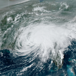
Hurricane Sally rapidly strengthened on its painfully slow approach to landfall last night, quickly becoming a strong category two hurricane with sustained winds of 105 MPH at landfall. The sudden and somewhat unexpected run-up in the hours before landfall exacerbated damage from wind and storm surge. The storm’s winds will weaken as it pushes farther inland, but its prolific rains are far from over.
The contiguous United States has seen four hurricanes make landfall this season—Hanna, Isaias, Laura, and Sally—and all four storms defied the odds to strengthen all the way until they made landfall. A slow-moving storm that suddenly intensifies as it approaches the coast is a scary scenario for folks in its path.
A few days ago, the National Hurricane Center’s showed Sally approaching major hurricane strength as it neared landfall, but forecasters (and most models) backed off that scenario because the storm started to struggle with some wind shear and dry air disrupting its internal structure.
The storm’s incredibly slow forward motion—just 2-3 MPH in the hours leading up to landfall—gave the system enough time to fight off the disruptions and fortify its eyewall, allowing the system to quickly strengthen as it approached Baldwin County, Alabama.
Widespread damage and power outages resulted from the intensity and duration of the storm’s winds. It’ll take another day or so to get a full picture of the damage, which could be particularly severe in coastal areas that also experienced a destructive storm surge.

For all the damage and surge, Sally’s legacy is still likely going to be the catastrophic flooding that resulted from more than two feet of rain. The map above shows the National Weather Service’s precipitation analysis for the past 24 hours ending at 8:00 AM Eastern today. Pockets of Baldwin and Escambia Counties saw more than two feet of rain long before storm was over.
Drenching rains continued well after the end of this analysis, so tomorrow’s analysis will give us a better view of the storm’s total rainfall across the region.

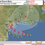
Sally weakened to a tropical storm over the western Florida Panhandle this afternoon. The system will continue to slowly weaken as it chugs through Alabama into Georgia tonight. The storm is still producing quite strong winds—60 MPH sustained winds for a few hours is nothing to sneeze at—and it won’t take much to blow over trees and power lines on wet soil.
Forecasters expect Tropical Storm Sally to lose its tropical characteristics on Thursday night as it enters the Carolinas. The precise track of the storm will determine which areas see the heaviest rain. Communities closer to the center of the storm will see higher rainfall totals, so any deviation from the NHC’s forecast track will drag the heaviest rains in the same direction.

The Weather Prediction Center’s latest rainfall forecast shows the potential for widespread flash flooding all the way through North Carolina as Sally and its remnants push toward the Atlantic Ocean. Many areas could see more than five inches of rain by the end of the storm on Friday afternoon. Flash flooding is likely near waterways and vulnerable roadways and urban areas where drainage systems can’t keep up with the tropical rainfall rates.
It’s worth noting that heavy rain is still falling across areas that were hard-hit by the storm last night. An additional inch or so of rain is possible across these areas before skies clear out behind the storm tonight.

As if all the wind and the rain wasn’t bad enough, there’s a notable tornado threat to the south and east of the storm’s track. Landfalling tropical cyclones are notorious for producing tornadoes as they push inland. There’s enough spin in the atmosphere that thunderstorms in the outer rainbands can form into small supercells that can spawn dangerous tornadoes. Tropical tornadoes usually happen quickly and they often don’t afford as much lead time as a “typical” tornado event.
The greatest threat for tornadoes will exist across northern Florida and southern Georgia for the rest of the afternoon and evening on Wednesday, moving east into Georgia and the Carolinas during the day on Friday.
If you haven’t already, turn on the wireless emergency alerts on your smartphone to make sure you’re alerted to a tornado warning the moment one is issued for your location.
[Satellite Image: NOAA]
You can follow me on Twitter or send me an email.
Please consider subscribing to my Patreon. Your support helps me write engaging, hype-free weather coverage—no fretting over ad revenue, no chasing viral clicks. Just the weather.